FAA INFORMATION EFFECTIVE 09 JULY 2026
Location
| FAA Identifier: | DTO |
| Lat/Long: | 33-12-07.0580N 097-11-56.7510W
33-12.117633N 097-11.945850W
33.2019606,-97.1990975
(estimated) |
| Elevation: | 642.8 ft. / 195.9 m (surveyed) |
| Variation: | 04E (2010) |
| From city: | 3 miles W of DENTON, TX |
| Time zone: | UTC -5 (UTC -6 during Standard Time) |
| Zip code: | 76207 |
Airport Operations
| Airport use: | Open to the public |
| Activation date: | 12/1946 |
| Control tower: | yes |
| ARTCC: | FORT WORTH CENTER |
| FSS: | FORT WORTH FLIGHT SERVICE STATION |
| NOTAMs facility: | DTO (NOTAM-D service available) |
| Attendance: | 0600-2200 |
| Pattern altitude: | 1442.8 ft. MSL |
| Wind indicator: | lighted |
| Segmented circle: | yes |
| Lights: | DUSK-DAWN WHEN ATCT CLSD, MIRL RWY 18L/36R & 18R/36L PRESET TO LOW INTST; TO INCR INTST & ACTVT MALSR RWY 18L - CTAF. |
| Beacon: | white-green (lighted land airport)
Operates sunset to sunrise. |
Airport Communications
| CTAF: | 119.95 |
| ATIS: | 119.325 |
| WX ASOS: | 119.325 (940-354-2971) |
| DENTON GROUND: | 123.95 [0600-2200] |
| DENTON TOWER: | 119.95 [0600-2200] |
| LONE STAR APPROACH: | 118.1 |
| LONE STAR DEPARTURE: | 118.1 |
| CLEARANCE DELIVERY: | 123.95 123.95 |
| BOTCH DP: | 118.1 |
| DALLAS AREA DP: | 118.1 |
| DODJE STAR: | 125.2 125.9 |
| GARLAND DP: | 118.1 |
| GREGS STAR: | 118.1 |
| HERBZ STAR: | 118.1 |
| JOE POOL DP: | 118.1 |
| LIKES STAR: | 125.8 ;SOUTH 135.975 ;NORTH |
| NANDR RNAV DP: | 118.1 |
| REEKO STAR: | 125.2 |
| SASIE STAR: | 124.3 |
| TRUUK RNAV STAR: | 124.3 |
| WX ASOS at AFW (14 nm SW): | PHONE 817-491-6188 |
| WX AWOS-3 at LUD (19 nm W): | 118.225 (940-627-2365) |
Nearby radio navigation aids
| VOR radial/distance | | VOR name | | Freq | | Var |
|---|
| FUZr351/18.8 | | RANGER VORTAC | | 115.70 | | 06E |
| TTTr332/21.5 | | MAVERICK VOR/DME | | 113.10 | | 06E |
| CVEr316/23.9 | | COWBOY VOR/DME | | 116.20 | | 06E |
| UKWr117/37.1 | | BOWIE VORTAC | | 117.15 | | 06E |
| NDB name | | Hdg/Dist | | Freq | | Var | | ID |
|---|
| PINCK | | 178/4.9 | | 257 | | 04E | | DT | -.. - |
Airport Services
| Fuel available: | 100LL JET-A |
| Parking: | hangars and tiedowns |
| Airframe service: | MAJOR |
| Powerplant service: | MAJOR |
| Bottled oxygen: | NONE |
| Bulk oxygen: | NONE |
Runway Information
Runway 18L/36R
| Dimensions: | 7002 x 150 ft. / 2134 x 46 m |
| Surface: | asphalt, in fair condition |
| Weight bearing capacity: | | Single wheel: | 70.0 | | Double wheel: | 100.0 |
|
| Runway edge lights: | medium intensity |
| RUNWAY 18L | | RUNWAY 36R |
| Latitude: | 33-12.703055N | | 33-11.548703N |
| Longitude: | 097-11.864263W | | 097-11.889745W |
| Elevation: | 639.3 ft. | | 627.0 ft. |
| Traffic pattern: | left | | left |
| Runway heading: | 177 magnetic, 181 true | | 357 magnetic, 001 true |
| Displaced threshold: | no | | 100 ft. |
| Declared distances: | TORA:7002 TODA:7002 ASDA:6502 LDA:6502 | | TORA:7002 TODA:7002 ASDA:6602 LDA:6502 |
| Markings: | precision, in good condition | | precision, in good condition |
| Visual slope indicator: | 4-light PAPI on left (3.00 degrees glide path) | | 4-light PAPI on left (3.00 degrees glide path) |
| Approach lights: | MALSR: 1,400 foot medium intensity approach lighting system with runway alignment indicator lights | | |
| Touchdown point: | yes, no lights | | yes, no lights |
| Instrument approach: | ILS | | |
| Obstructions: | 20 ft. trees, 720 ft. from runway, 185 ft. right of centerline, 26:1 slope to clear
15 FT LOCALIZER ANT, 500 FT DSTC, OBSTN CLNC 20:1, 40:1 TO DTHR. | | 20 ft. trees, 890 ft. from runway, 250 ft. left of centerline, 34:1 slope to clear
OBSTN CLNC 49:1 TO DTHR OVR 20 FT TREES, 980 DSTC, 40:1 OVR LOC ANT, 600 FT DSTC. |
Runway 18R/36L
| Dimensions: | 5003 x 75 ft. / 1525 x 23 m |
| Surface: | asphalt, in excellent condition |
| Weight bearing capacity: | |
| Runway edge lights: | medium intensity |
| RUNWAY 18R | | RUNWAY 36L |
| Latitude: | 33-12.518482N | | 33-11.693710N |
| Longitude: | 097-12.033267W | | 097-12.051152W |
| Elevation: | 642.8 ft. | | 627.4 ft. |
| Traffic pattern: | left | | left |
| Runway heading: | 177 magnetic, 181 true | | 357 magnetic, 001 true |
| Markings: | nonprecision, in good condition | | nonprecision, in good condition |
| Visual slope indicator: | 4-light PAPI on left (3.00 degrees glide path) | | 4-light PAPI on left (3.00 degrees glide path) |
| Touchdown point: | yes, no lights | | yes, no lights |
Airport Ownership and Management from official FAA records
| Ownership: | Publicly-owned |
| Owner: | CITY OF DENTON
601 EAST HICKORY STREET
DENTON, TX 76201
Phone 940-349-7736 |
| Manager: | RYAN ADAMS
5000 AIRPORT RD
DENTON, TX 76207-0207
Phone 940-349-7744
RYAN.ADAMS@CITYOFDENTON.COM |
Additional Remarks
| - | RWY 18L DESIGNATED AS A CALM WIND RWY. |
| - | ARPT CLSD TO ULTRALIGHTS AND GLIDERS. |
| - | MOWING OPNS ON ARPT MAY-SEP. |
| - | FOR CD WHEN ATCT IS CLSD CTC LONE STAR APCH AT 972-615-2799. |
Instrument Procedures
NOTE: All procedures below are presented as PDF files. If you need a reader for these files, you should download the free Adobe Reader.NOT FOR NAVIGATION. Please procure official charts for flight.
FAA instrument procedures published for use from 09 July 2026 at 0901Z to 06 August 2026 at 0900Z.
STARs - Standard Terminal Arrivals |
|---|
| DODJE SIX **NEW** | |
2 pages:
[1] [2] (673KB) |
| GREGS ONE **NEW** | |
2 pages:
[1] [2] (469KB) |
| HERBZ TWO (RNAV) **NEW** | |
download (281KB) |
| JFRYE FIVE (RNAV) **NEW** | |
download (257KB) |
| LIKES FOUR (RNAV) **NEW** | |
download (192KB) |
| REEKO THREE (RNAV) **NEW** | |
download (214KB) |
| SASIE EIGHT **NEW** | |
2 pages:
[1] [2] (437KB) |
| TRUUK THREE (RNAV) **NEW** | |
download (198KB) |
IAPs - Instrument Approach Procedures |
|---|
| ILS OR LOC RWY 18L | |
download (287KB) |
| RNAV (GPS) RWY 18L | |
download (256KB) |
| RNAV (GPS) RWY 18R | |
download (265KB) |
| RNAV (GPS) RWY 36L | |
download (239KB) |
| RNAV (GPS) RWY 36R | |
download (246KB) |
| NOTE: Special Alternate Minimums apply | |
download (139KB) |
Departure Procedures |
|---|
| BOTCH TWO (RNAV) | |
2 pages:
[1] [2] (349KB) |
| DALLAS FOUR | |
2 pages:
[1] [2] (317KB) |
| GARLAND SIX | |
2 pages:
[1] [2] (314KB) |
| JOE POOL EIGHT | |
2 pages:
[1] [2] (434KB) |
| KINGDOM FIVE | |
2 pages:
[1] [2] (338KB) |
| KUSSO THREE (RNAV) | |
2 pages:
[1] [2] (317KB) |
| NANDR FOUR (RNAV) **CHANGED** | |
2 pages:
[1] [2] (322KB) |
| TEXOMA FIVE | |
2 pages:
[1] [2] (423KB) |
| WORTH ONE | |
2 pages:
[1] [2] (404KB) |
| NOTE: Special Take-Off Minimums/Departure Procedures apply | |
download (300KB) |
Other nearby airports with instrument procedures:
KAFW - Perot Field/Fort Worth Alliance Airport (14 nm SW)
KLUD - Decatur Municipal Airport (19 nm W)
4T2 - Kenneth Copeland Airport (20 nm SW)
KDFW - Dallas-Fort Worth International Airport (20 nm SE)
KADS - Addison Airport (23 nm SE)
|
|

Road maps at:
MapQuest
Bing
Google
| Aerial photo |
|---|
WARNING: Photo may not be current or correct
 Photo taken 20-Oct-2017
looking south.
Photo taken 20-Oct-2017
looking south.
Do you have a better or more recent aerial photo of Denton Enterprise Airport that you would like to share? If so, please send us your photo.
|
| Sectional chart |
|---|
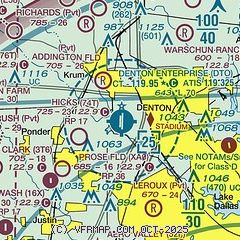
|
CAUTION: Diagram may not be current
 Download PDF
of official airport diagram from the FAA
| Airport distance calculator |
|---|
|
|
| Sunrise and sunset |
|---|
|
Times for 31-Jul-2026
| | Local
(UTC-5) | | Zulu
(UTC) |
|---|
| Morning civil twilight | | 06:15 | | 11:15 |
| Sunrise | | 06:42 | | 11:42 |
| Sunset | | 20:28 | | 01:28 |
| Evening civil twilight | | 20:55 | | 01:55 |
|
| Current date and time |
|---|
| Zulu (UTC) | 31-Jul-2026 05:26:13 |
|---|
| Local (UTC-5) | 31-Jul-2026 00:26:13 |
|---|
|
| METAR |
|---|
| KDTO | 310453Z AUTO 15005KT 10SM CLR 31/20 A2992 RMK AO2 SLP118 T03060200
|
KAFW
15nm SW | 310453Z 16012KT 10SM FEW250 32/17 A2991 RMK AO2 SLP108 T03220167
|
KLUD
19nm W | 118.22 940-927-2365
310515Z AUTO 17008KT 10SM CLR 32/18 A2994 RMK AO2
|
|
| TAF |
|---|
KAFW
15nm SW | 310240Z 3103/3124 19011KT P6SM FEW070 SCT250
|
|
| NOTAMs |
|---|
NOTAMs are issued by the DoD/FAA and will open in a separate window not controlled by AirNav.
|
|


