FAA INFORMATION EFFECTIVE 09 JULY 2026
Location
| FAA Identifier: | MAO |
| Lat/Long: | 34-10-52.1980N 079-20-04.9910W
34-10.869967N 079-20.083183W
34.1811661,-79.3347197
(estimated) |
| Elevation: | 92.7 ft. / 28.3 m (surveyed) |
| Variation: | 08W (2015) |
| From city: | 3 miles E of MARION, SC |
| Time zone: | UTC -4 (UTC -5 during Standard Time) |
| Zip code: | 29574 |
Airport Operations
| Airport use: | Open to the public |
| Activation date: | 10/1960 |
| Control tower: | no |
| ARTCC: | JACKSONVILLE CENTER |
| FSS: | ANDERSON FLIGHT SERVICE STATION |
| NOTAMs facility: | AND (NOTAM-D service available) |
| Attendance: | 0700-1700
ARPT CLOSED CHRISTMAS, THANKSGIVING, NEW YEAR'S DAY. |
| Wind indicator: | lighted |
| Segmented circle: | yes |
| Lights: | PAPI RWY 04 & 22; MIRL RWY 04/22 OPR SS-SR. |
| Beacon: | white-green (lighted land airport)
Operates sunset to sunrise. |
Airport Communications
| CTAF/UNICOM: | 122.8 |
| WX AWOS-3PT: | 119.875 (843-423-4231) |
| FLORENCE APPROACH: | 135.25 |
| FLORENCE DEPARTURE: | 135.25 |
| WX ASOS at FLO (19 nm W): | PHONE 843-665-1306 |
- APCH/DEP SVC PRVDD BY JACKSONVILLE ARTCC ON FREQS 133.45/306.3 (FLORENCE RCAG) WHEN FLORENCE APCH CTL CLSD.
Nearby radio navigation aids
| VOR radial/distance | | VOR name | | Freq | | Var |
|---|
| FLOr104/16.3 | | FLORENCE VORTAC | | 115.20 | | 03W |
| CREr309/37.5 | | GRAND STRAND VORTAC | | 114.40 | | 03W |
| NDB name | | Hdg/Dist | | Freq | | Var | | ID |
|---|
| EVANS | | 054/29.0 | | 420 | | 06W | | CFY | -.-. ..-. -.-- |
Airport Services
| Fuel available: | 100LL JET-A
100LL:FOR FUEL AFTER HRS CTC 843-526-1409. |
| Parking: | hangars and tiedowns |
| Airframe service: | NONE |
| Powerplant service: | NONE |
| Bottled oxygen: | NONE |
| Bulk oxygen: | NONE |
Runway Information
Runway 4/22
| Dimensions: | 4505 x 100 ft. / 1373 x 30 m |
| Surface: | asphalt, in fair condition |
| Weight bearing capacity: | | PCN 11 /F/C/Y/T | | Single wheel: | 30.5 | | Double wheel: | 46.5 |
|
| Runway edge lights: | medium intensity |
| RUNWAY 4 | | RUNWAY 22 |
| Latitude: | 34-10.564373N | | 34-11.175545N |
| Longitude: | 079-20.337047W | | 079-19.829278W |
| Elevation: | 92.4 ft. | | 90.9 ft. |
| Traffic pattern: | right | | right |
| Runway heading: | 043 magnetic, 035 true | | 223 magnetic, 215 true |
| Markings: | nonprecision, in fair condition | | nonprecision, in fair condition |
| Visual slope indicator: | 2-light PAPI on left (3.00 degrees glide path) | | 2-light PAPI on left (3.00 degrees glide path) |
| Touchdown point: | yes, no lights | | yes, no lights |
| Obstructions: | 57 ft. tree, 1889 ft. from runway, 377 ft. right of centerline, 29:1 slope to clear | | 43 ft. tree, 882 ft. from runway, 94 ft. left of centerline, 15:1 slope to clear
9 FT HIGH BRUSH 133 FT FROM THLD 129 FT LEFT OF CNTRLN. |
Airport Ownership and Management from official FAA records
| Ownership: | Publicly-owned |
| Owner: | MARION COUNTY
PO BOX 183
MARION, SC 29571
Phone 843-423-3904 |
| Manager: | CHARLES TAYLOR
225 AIRPORT COURT
MULLINS, SC 29574
Phone 843-423-8265 |
Additional Remarks
| - | STUDENT TRG ON & INVOF ARPT. |
| - | FOR CD CTC FLORENCE APCH AT 843-665-0632, WHEN APCH CLSD CTC JACKSONVILLE ARTCC AT 904-845-1592. |
Instrument Procedures
NOTE: All procedures below are presented as PDF files. If you need a reader for these files, you should download the free Adobe Reader.NOT FOR NAVIGATION. Please procure official charts for flight.
FAA instrument procedures published for use from 09 July 2026 at 0901Z to 06 August 2026 at 0900Z.
IAPs - Instrument Approach Procedures |
|---|
| RNAV (GPS) RWY 04 | |
download (261KB) |
| RNAV (GPS) RWY 22 | |
download (234KB) |
| NOTE: Special Alternate Minimums apply | |
download (169KB) |
| NOTE: Special Take-Off Minimums/Departure Procedures apply | |
download |
Other nearby airports with instrument procedures:
KDLC - Dillon County Airport (16 nm N)
KFLO - Florence Regional Airport (19 nm W)
KHYW - Conway-Horry County Airport (24 nm SE)
5J9 - Twin City Airport (24 nm E)
KLBT - Lumberton Regional Airport (29 nm NE)
|
|

Road maps at:
MapQuest
Bing
Google
| Aerial photo |
|---|
WARNING: Photo may not be current or correct
 Photo by Erika M. Nash
Do you have a better or more recent aerial photo of Marion County Airport that you would like to share? If so, please send us your photo.
|
| Sectional chart |
|---|
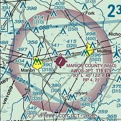
|
| Airport distance calculator |
|---|
|
|
| Sunrise and sunset |
|---|
|
Times for 12-Jul-2026
| | Local
(UTC-4) | | Zulu
(UTC) |
|---|
| Morning civil twilight | | 05:47 | | 09:47 |
| Sunrise | | 06:16 | | 10:16 |
| Sunset | | 20:30 | | 00:30 |
| Evening civil twilight | | 20:59 | | 00:59 |
|
| Current date and time |
|---|
| Zulu (UTC) | 12-Jul-2026 07:11:01 |
|---|
| Local (UTC-4) | 12-Jul-2026 03:11:01 |
|---|
|
| METAR |
|---|
| KMAO | 120655Z AUTO 25003KT 10SM CLR 22/20 A3003 RMK AO2
|
KFLO
20nm W | 120653Z 23004KT 10SM CLR 23/22 A3003 RMK AO2 SLP166 T02330222
|
|
| TAF |
|---|
KFLO
20nm W | 120520Z 1206/1306 29004KT P6SM SCT100 FM121900 35005KT P6SM VCTS BKN070CB FM122200 02004KT 4SM TSRA BKN045CB FM130300 VRB03KT 6SM -SHRA BKN030
|
|
| NOTAMs |
|---|
NOTAMs are issued by the DoD/FAA and will open in a separate window not controlled by AirNav.
|
|


