FAA INFORMATION EFFECTIVE 03 SEPTEMBER 2026
Location
| FAA Identifier: | MKY |
| Lat/Long: | 25-59-42.1000N 081-40-21.1000W
25-59.701667N 081-40.351667W
25.9950278,-81.6725278
(estimated) |
| Elevation: | 5.2 ft. / 1.6 m (surveyed) |
| Variation: | 03W (1995) |
| From city: | 4 miles NE of MARCO ISLAND, FL |
| Time zone: | UTC -4 (UTC -5 during Standard Time) |
| Zip code: | 34114 |
Airport Operations
| Airport use: | Open to the public |
| Control tower: | no |
| ARTCC: | MIAMI CENTER |
| FSS: | MIAMI FLIGHT SERVICE STATION |
| NOTAMs facility: | MIA (NOTAM-D service available) |
| Attendance: | 0700-1900 |
| Wind indicator: | lighted |
| Segmented circle: | yes |
| Lights: | ACTVT REIL RWY 17 & 35; PAPI RWY 17 & 35; MIRL RWY 17/35 - CTAF. |
| Beacon: | white-green (lighted land airport)
Operates sunset to sunrise. |
| Landing fee: | yes, RAMP FEE |
Airport Communications
| CTAF/UNICOM: | 122.7 |
| WX AWOS-3PT: | 120.075 (239-394-8187) |
| FORT MYERS APPROACH: | 124.125 |
| FORT MYERS DEPARTURE: | 124.125 |
| CLEARANCE DELIVERY: | 120.8 |
| PIKKR STAR: | 127.05 ;5000 FT & BLO 134.425 ;6000 FT & ABV |
| SHFTY STAR: | 126.8 |
| ZEILR STAR: | 134.425 |
| WX ASOS at APF (11 nm NW): | 134.225 (239-643-9886) |
- APCH/DEP SVC PRVDD BY MIAMI ARTCC ON FREQS 134.75/322.5 (FORT MYERS RCAG) WHEN FORT MYERS APCH CTL CLSD.
Nearby radio navigation aids
| VOR radial/distance | | VOR name | | Freq | | Var |
|---|
| RSWr172/32.6 | | LEE COUNTY VORTAC | | 114.15 | | 02W |
Airport Services
| Fuel available: | 100LL JET-A JET-A+
100LL:SELF SVC AVGAS 100LL AVBL 24 HRS BY CREDIT CARD. |
| Parking: | tiedowns |
| Airframe service: | MINOR |
| Powerplant service: | MINOR |
| Bottled oxygen: | NONE |
| Bulk oxygen: | NONE |
Runway Information
Runway 17/35
| Dimensions: | 5000 x 100 ft. / 1524 x 30 m |
| Surface: | asphalt/grooved, in good condition |
| Weight bearing capacity: | | PCN PCN/26 /F/A/W/T | | Single wheel: | /2015 | | Double wheel: | 75.0 | | Double tandem: | 108.0 |
|
| Runway edge lights: | medium intensity |
| RUNWAY 17 | | RUNWAY 35 |
| Latitude: | 26-00.105652N | | 25-59.299202N |
| Longitude: | 081-40.448983W | | 081-40.254502W |
| Elevation: | 5.0 ft. | | 5.1 ft. |
| Traffic pattern: | left | | right |
| Runway heading: | 171 magnetic, 168 true | | 351 magnetic, 348 true |
| Markings: | nonprecision, in fair condition | | nonprecision, in fair condition |
| Visual slope indicator: | 4-light PAPI on left (3.00 degrees glide path) | | 4-light PAPI on left (3.00 degrees glide path) |
| Runway end identifier lights: | yes | | yes |
| Touchdown point: | yes, no lights | | yes, no lights |
| Instrument approach: | LOCALIZER | | |
| Obstructions: | 12 ft. brush, 355 ft. from runway, 12:1 slope to clear
RWY 17 APCH RATIO 27:1 TO RWY END. | | 5 ft. brush, 328 ft. from runway, 28:1 slope to clear
RY 35 APCH RATIO 34:1 TO RY END. |
Airport Ownership and Management from official FAA records
| Ownership: | Publicly-owned |
| Owner: | COLLIER COUNTY AIRPORT AUTHORITY
2005 MAINSAIL DRIVE
NAPLES, FL 34114
Phone 239-252-8400 |
| Manager: | BRYANT GARRETT
2005 MAINSAIL DRIVE, SUITE 1
NAPLES, FL 34114
Phone 239-252-8425 |
Additional Remarks
| - | FOR CD CTC FORT MYERS APCH AT239-416-1026, WHEN APCH CLSD CTC MIAMI ARTCC AT 305-716-1731. |
| - | RWY 35 DSGND CALM WIND RWY FOR ARRS 2200-0700. RWY 17 DSGND CALM WIND RWY FOR DEPS 2200-0700. |
| - | FM NOV 1ST TO APR 30TH - 24 HR PPR REQ FOR ACFT OVNGT PRKG. |
| - | ARPT VSBY UNRELIABLE. |
| - | NOISE SENSITIVE AREA. USE NBAA CLOSE IN NOISE ABATEMMENT PROCEDURES. |
| - | BANNER TOWING ON AND INVOF ARPT. |
| - | FOR FUEL AND SVC AFTER HRS CALL 239-252-8380. |
| - | NUMEROUS BIRDS & WILDLIFE ON AND INVOF ARPT. |
Instrument Procedures
NOTE: All procedures below are presented as PDF files. If you need a reader for these files, you should download the free Adobe Reader.NOT FOR NAVIGATION. Please procure official charts for flight.
FAA instrument procedures published for use from 03 September 2026 at 0901Z to 01 October 2026 at 0900Z.
STARs - Standard Terminal Arrivals |
|---|
| PIKKR SEVEN (RNAV) | |
download (208KB) |
| SHFTY SIX (RNAV) | |
2 pages:
[1] [2] (484KB) |
| ZEILR SIX **CHANGED** | |
download (121KB) |
IAPs - Instrument Approach Procedures |
|---|
| RNAV (GPS) RWY 17 **CHANGED** | |
download (237KB) |
| RNAV (GPS) RWY 35 | |
download (258KB) |
| NOTE: Special Alternate Minimums apply | |
download (124KB) |
Departure Procedures |
|---|
| CSHEL EIGHT (RNAV) | |
download (253KB) |
| NOTE: Special Take-Off Minimums/Departure Procedures apply | |
download (408KB) |
Other nearby airports with instrument procedures:
KAPF - Naples Municipal Airport (11 nm NW)
KIMM - Immokalee Regional Airport (30 nm NE)
KRSW - Southwest Florida International Airport (33 nm N)
KFMY - Page Field Airport (37 nm N)
KTNT - Dade-Collier Training and Transition Airport (43 nm E)
|
|

Road maps at:
MapQuest
Bing
Google
| Aerial photo |
|---|
WARNING: Photo may not be current or correct
 As seen circa 2016
looking southeast.
As seen circa 2016
looking southeast.
Do you have a better or more recent aerial photo of Marco Island Executive Airport that you would like to share? If so, please send us your photo.
|
| Sectional chart |
|---|
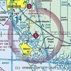
|
CAUTION: Diagram may not be current

| Airport distance calculator |
|---|
|
|
| Sunrise and sunset |
|---|
|
Times for 04-Sep-2026
| | Local
(UTC-4) | | Zulu
(UTC) |
|---|
| Morning civil twilight | | 06:46 | | 10:46 |
| Sunrise | | 07:09 | | 11:09 |
| Sunset | | 19:42 | | 23:42 |
| Evening civil twilight | | 20:06 | | 00:06 |
|
| Current date and time |
|---|
| Zulu (UTC) | 04-Sep-2026 08:53:35 |
|---|
| Local (UTC-4) | 04-Sep-2026 04:53:35 |
|---|
|
| METAR |
|---|
| KMKY | 040807Z AUTO 15005KT 10SM -TSRA FEW033 SCT042 SCT060 27/26 A2994 RMK AO2 LTG DSNT SE TSB01 PNO $
|
KAPF
10nm NW | 040840Z AUTO 09004KT 10SM FEW029 SCT039 27/26 A2993 RMK AO2 T02720256
|
|
| TAF |
|---|
KAPF
10nm NW | 040535Z 0406/0506 VRB04KT P6SM SCT150 FM040800 VRB04KT P6SM VCSH SCT030 SCT060 FM041600 23008KT P6SM VCTS SCT030CB SCT060 FM050100 VRB04KT P6SM FEW030 SCT100
|
|
| NOTAMs |
|---|
NOTAMs are issued by the DoD/FAA and will open in a separate window not controlled by AirNav.
|
|


