FAA INFORMATION EFFECTIVE 11 JUNE 2026
Location
| FAA Identifier: | MYV |
| Lat/Long: | 39-05-52.0000N 121-34-11.4000W
39-05.866667N 121-34.190000W
39.0977778,-121.5698333
(estimated) |
| Elevation: | 64.3 ft. / 19.6 m (surveyed) |
| Variation: | 16E (1985) |
| From city: | 3 miles SE of MARYSVILLE, CA |
| Time zone: | UTC -7 (UTC -8 during Standard Time) |
| Zip code: | 95901 |
Airport Operations
| Airport use: | Open to the public |
| Activation date: | 12/1943 |
| Control tower: | no |
| ARTCC: | OAKLAND CENTER |
| FSS: | RANCHO MURIETA FLIGHT SERVICE STATION |
| NOTAMs facility: | MYV (NOTAM-D service available) |
| Attendance: | 0600-1800 |
| Wind indicator: | yes |
| Segmented circle: | yes |
| Lights: | ACTVT MALSR RWY 14; VASI RWY 14 & 32, HIRL RWY 14/32 - CTAF |
| Beacon: | white-green (lighted land airport)
Operates sunset to sunrise. |
Airport Communications
| CTAF/UNICOM: | 123.05 |
| WX ASOS: | 118.475 (530-742-0695) |
| NORCAL APPROACH: | 125.4 |
| NORCAL DEPARTURE: | 125.4 |
| WX AWOS-3 at LHM (15 nm SE): | 124.25 (916-645-0698) |
Nearby radio navigation aids
| VOR radial/distance | | VOR name | | Freq | | Var |
|---|
| MYV at field | | MARYSVILLE VOR/DME | | 110.80 | | 16E |
| ILAr068/21.4 | | WILLIAMS VORTAC | | 114.40 | | 18E |
| MCCr326/27.0 | | MC CLELLAN VOR/DME | | 109.20 | | 17E |
| SACr342/39.3 | | SACRAMENTO VORTAC | | 115.20 | | 17E |
Airport Services
| Fuel available: | 100LL JET-A |
| Parking: | hangars and tiedowns |
| Airframe service: | MAJOR |
| Powerplant service: | MINOR |
| Bottled oxygen: | NONE |
| Bulk oxygen: | NONE |
Runway Information
Runway 14/32
| Dimensions: | 6007 x 150 ft. / 1831 x 46 m |
| Surface: | asphalt, in good condition |
| Weight bearing capacity: | | Single wheel: | 75.0 | | Double wheel: | 100.0 | | Double tandem: | 150.0 |
|
| Runway edge lights: | high intensity |
| RUNWAY 14 | | RUNWAY 32 |
| Latitude: | 39-06.294633N | | 39-05.385330N |
| Longitude: | 121-34.475352W | | 121-33.974473W |
| Elevation: | 63.2 ft. | | 60.1 ft. |
| Traffic pattern: | left | | left |
| Runway heading: | 141 magnetic, 157 true | | 321 magnetic, 337 true |
| Markings: | precision, in good condition | | precision, in good condition |
| Visual slope indicator: | 4-box VASI on left (3.00 degrees glide path) | | 4-box VASI on left (3.00 degrees glide path) |
| Approach lights: | MALSR: 1,400 foot medium intensity approach lighting system with runway alignment indicator lights | | |
| Runway end identifier lights: | no | | no |
| Touchdown point: | yes, no lights | | yes, no lights |
| Instrument approach: | ILS | | |
| Obstructions: | 65 ft. tree, 3200 ft. from runway, 300 ft. left of centerline, 44:1 slope to clear | | 39 ft. pole, 1750 ft. from runway, 175 ft. right of centerline, 39:1 slope to clear |
Runway 5/23
| Dimensions: | 3314 x 60 ft. / 1010 x 18 m |
| Surface: | asphalt, in poor condition
RWY 5/23 ASPH SFC IS IN POOR COND WITH RAVELING AND SPALLING ASPH, AND LONGL AND LATERAL CRACKING. |
| Weight bearing capacity: | | Single wheel: | 42.0 | | Double wheel: | 60.0 | | Double tandem: | 95.0 |
|
| Runway edge markings: | MRKGS ARE FADED. |
| RUNWAY 5 | | RUNWAY 23 |
| Latitude: | 39-05.808125N | | 39-06.023350N |
| Longitude: | 121-34.446080W | | 121-33.802245W |
| Elevation: | 61.9 ft. | | 64.3 ft. |
| Traffic pattern: | left | | left |
| Runway heading: | 051 magnetic, 067 true | | 231 magnetic, 247 true |
| Markings: | basic, in poor condition | | basic, in poor condition |
| Runway end identifier lights: | no | | no |
| Touchdown point: | yes, no lights | | yes, no lights |
| Obstructions: | 25 ft. rr, 800 ft. from runway, 200 ft. left of centerline, 24:1 slope to clear | | 45 ft. tree, 900 ft. from runway, 50 ft. right of centerline, 15:1 slope to clear |
Airport Ownership and Management from official FAA records
| Ownership: | Publicly-owned |
| Owner: | YUBA COUNTY
915 8TH STREET
MARYSVILLE, CA 95901
Phone 530-749-7800 |
| Manager: | JASON KOPPING
1364 SKY HARBOR DRIVE
OLIVEHURST, CA 95961
Phone 530-749-7800 |
Additional Remarks
| - | RY 23 +35 FT PLINES 900-1050 FT FM RY END; RUNNING 145 FT LEFT TO 210 FT RIGHT. |
| - | MIGRATORY FLOCKS OF WATERFOWL IN VICINITY OF AIRPORT DURING THE SPRING AND FALL OF THE YEAR. |
| - | FOR CD CTC NORCAL APCH AT 916-361-6874. |
Instrument Procedures
NOTE: All procedures below are presented as PDF files. If you need a reader for these files, you should download the free Adobe Reader.NOT FOR NAVIGATION. Please procure official charts for flight.
FAA instrument procedures published for use from 11 June 2026 at 0901Z to 09 July 2026 at 0900z.
IAPs - Instrument Approach Procedures |
|---|
| ILS OR LOC RWY 14 | |
download (245KB) |
| RNAV (GPS) RWY 14 **CHANGED** | |
download (218KB) |
| RNAV (GPS) RWY 32 **CHANGED** | |
download (208KB) |
| NOTE: Special Alternate Minimums apply | |
download (23KB) |
| NOTE: Special Take-Off Minimums/Departure Procedures apply | |
download (129KB) |
Other nearby airports with instrument procedures:
KBAB - Beale Air Force Base (7 nm E)
KLHM - Lincoln Regional Airport/Karl Harder Field (15 nm SE)
O08 - Sidney Pickels Field Airport (20 nm W)
KOVE - Oroville Municipal Airport (24 nm N)
KSMF - Sacramento International Airport (24 nm S)
|
|

Road maps at:
MapQuest
Bing
Google
| Aerial photo |
|---|
WARNING: Photo may not be current or correct

Do you have a better or more recent aerial photo of Yuba County Airport that you would like to share? If so, please send us your photo.
|
| Sectional chart |
|---|
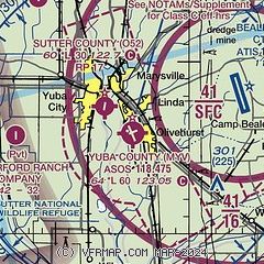
|
CAUTION: Diagram may not be current

| Airport distance calculator |
|---|
|
|
| Sunrise and sunset |
|---|
|
Times for 30-Jun-2026
| | Local
(UTC-7) | | Zulu
(UTC) |
|---|
| Morning civil twilight | | 05:12 | | 12:12 |
| Sunrise | | 05:45 | | 12:45 |
| Sunset | | 20:35 | | 03:35 |
| Evening civil twilight | | 21:07 | | 04:07 |
|
| Current date and time |
|---|
| Zulu (UTC) | 01-Jul-2026 03:47:42 |
|---|
| Local (UTC-7) | 30-Jun-2026 20:47:42 |
|---|
|
| METAR |
|---|
KBAB
7nm E | 010255Z 20008KT 10SM CLR 29/09 A2974 RMK AO2A SLP073 T02910092 56008 $
|
KLHM
15nm SE | 010335Z AUTO 20007KT 10SM CLR 25/06 A2976 RMK AO1
|
|
| TAF |
|---|
KBAB
7nm E | 301900Z 3019/0201 18009KT 9999 SKC QNH2972INS BECMG 0102/0103 15009KT 9999 SKC QNH2972INS WND 12006KT AFT 0107 TX34/3023Z TN14/0113Z
|
|
| NOTAMs |
|---|
NOTAMs are issued by the DoD/FAA and will open in a separate window not controlled by AirNav.
|
|


