FAA INFORMATION EFFECTIVE 09 JULY 2026
Location
| FAA Identifier: | LHM |
| Lat/Long: | 38-54-33.0000N 121-21-04.8000W
38-54.550000N 121-21.080000W
38.9091667,-121.3513333
(estimated) |
| Elevation: | 121.4 ft. / 37.0 m (surveyed) |
| Variation: | 14E (2010) |
| From city: | 3 miles W of LINCOLN, CA |
| Time zone: | UTC -7 (UTC -8 during Standard Time) |
| Zip code: | 95648 |
Airport Operations
| Airport use: | Open to the public |
| Activation date: | 07/1944 |
| Control tower: | no |
| ARTCC: | OAKLAND CENTER |
| FSS: | RANCHO MURIETA FLIGHT SERVICE STATION |
| NOTAMs facility: | RIU (NOTAM-D service available) |
| Attendance: | MON-FRI 0630 - 1500 |
| Wind indicator: | lighted |
| Segmented circle: | yes |
| Lights: | ACTVT MALSR RWY 15; MIRL RWY 15/33, HELI PERIMETER LGTS - CTAF. PAPI RWYS 15 & 33 TURNED ON DURING DALGT HRS, AFTER DARK ACTVT - CTAF. |
| Beacon: | white-green (lighted land airport)
Operates sunset to sunrise. |
Airport Communications
| CTAF/UNICOM: | 123.0 |
| WX AWOS-3: | 124.25 (916-645-0698) |
| NORCAL APPROACH: | 125.4 [1600-0800Z++ MON-FRI, 1800-0200Z++ SAT-SUN] |
| NORCAL DEPARTURE: | 125.4 [1600-0800Z++ MON-FRI, 1800-0200Z++ SAT-SUN] |
| WX AWOS-3 at AUN (13 nm E): | 119.375 (530-888-8934) |
| WX AWOS-3 at MCC (15 nm S): | 125.975 (916-641-1272) |
| WX ASOS at MYV (15 nm NW): | 118.475 (530-742-0695) |
| WX ASOS at SMF (17 nm SW): | PHONE 916-649-3996 |
Nearby radio navigation aids
| VOR radial/distance | | VOR name | | Freq | | Var |
|---|
| MCCr353/14.7 | | MC CLELLAN VOR/DME | | 109.20 | | 17E |
| MYVr122/15.4 | | MARYSVILLE VOR/DME | | 110.80 | | 16E |
| SACr002/29.5 | | SACRAMENTO VORTAC | | 115.20 | | 17E |
| HNWr274/30.2 | | HANGTOWN VOR/DME | | 115.50 | | 17E |
| ILAr089/33.0 | | WILLIAMS VORTAC | | 114.40 | | 18E |
Airport Services
| Fuel available: | 100LL JET-A
100LL:FOR JET A AND 100LL FUEL TRUCK CTC (916) 257-4854, 0600-1700. SELF SVC FUEL AVBL 24 HRS. |
| Parking: | tiedowns |
| Airframe service: | MAJOR |
| Powerplant service: | MAJOR |
| Bottled oxygen: | NONE |
| Bulk oxygen: | NONE |
Runway Information
Runway 15/33
| Dimensions: | 6001 x 100 ft. / 1829 x 30 m |
| Surface: | asphalt, in good condition |
| Weight bearing capacity: | | Single wheel: | 30.0 | | Double wheel: | 60.0 |
|
| Runway edge lights: | medium intensity |
| RUNWAY 15 | | RUNWAY 33 |
| Latitude: | 38-55.027855N | | 38-54.071655N |
| Longitude: | 121-21.240792W | | 121-20.919870W |
| Elevation: | 119.8 ft. | | 119.7 ft. |
| Traffic pattern: | left | | left |
| Runway heading: | 151 magnetic, 165 true | | 331 magnetic, 345 true |
| Markings: | precision, in good condition | | nonprecision, in good condition |
| Visual slope indicator: | 4-light PAPI on left (3.00 degrees glide path) | | 4-light PAPI on left (3.00 degrees glide path) |
| Approach lights: | MALSR: 1,400 foot medium intensity approach lighting system with runway alignment indicator lights | | |
| Runway end identifier lights: | no | | no |
| Touchdown point: | yes, no lights | | yes, no lights |
| Instrument approach: | ILS/DME | | |
| Obstructions: | 25 ft. tree, 1000 ft. from runway, 32:1 slope to clear | | 40 ft. trees, 1600 ft. from runway, 35:1 slope to clear |
Helipad H1
| Dimensions: | 60 x 60 ft. / 18 x 18 m |
| Surface: | concrete |
| Runway edge lights: | PERI |
| Latitude: | 38-54.208117N | | |
| Longitude: | 121-20.726117W | | |
| Elevation: | 118.0 ft. | | |
| Traffic pattern: | left | | left |
Airport Ownership and Management from official FAA records
| Ownership: | Publicly-owned |
| Owner: | CITY OF LINCOLN
600 6TH STREET
LINCOLN, CA 95648
Phone (916) 434-2450 |
| Manager: | RICHARD SPINALE
600 SIXTH STREET
LINCOLN, CA 95648
Phone 916-645-3443
EMAIL: RSPINALE@LINCOLNCA.GOV. |
Additional Remarks
| A30A-15 | RY 15 CALM WND RY. |
| - | FOR CD CTC NORCAL APCH AT 916-361-6874. |
| - | PWRD PRCHT ACT SW QUAD OF ARPT. |
Instrument Procedures
NOTE: All procedures below are presented as PDF files. If you need a reader for these files, you should download the free Adobe Reader.NOT FOR NAVIGATION. Please procure official charts for flight.
FAA instrument procedures published for use from 09 July 2026 at 0901Z to 06 August 2026 at 0900Z.
IAPs - Instrument Approach Procedures |
|---|
| ILS OR LOC RWY 15 | |
download (275KB) |
| RNAV (GPS) RWY 15 | |
download (241KB) |
| RNAV (GPS) RWY 33 | |
download (210KB) |
| NOTE: Special Alternate Minimums apply | |
download (133KB) |
| NOTE: Special Take-Off Minimums/Departure Procedures apply | |
download (346KB) |
Other nearby airports with instrument procedures:
KAUN - Auburn Municipal Airport (13 nm E)
KBAB - Beale Air Force Base (14 nm N)
KMCC - Mc Clellan Airfield (15 nm S)
KMYV - Yuba County Airport (15 nm NW)
KSMF - Sacramento International Airport (17 nm SW)
|
|

Road maps at:
MapQuest
Bing
Google
| Aerial photo |
|---|
WARNING: Photo may not be current or correct
 Photo by Rockne Green
Photo taken 29-Sep-2009
Photo by Rockne Green
Photo taken 29-Sep-2009
Do you have a better or more recent aerial photo of Lincoln Regional Airport/Karl Harder Field that you would like to share? If so, please send us your photo.
|
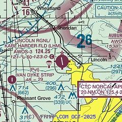
| Sectional chart |
|---|
|
| Airport distance calculator |
|---|
|
|
| Sunrise and sunset |
|---|
|
Times for 25-Jul-2026
| | Local
(UTC-7) | | Zulu
(UTC) |
|---|
| Morning civil twilight | | 05:31 | | 12:31 |
| Sunrise | | 06:01 | | 13:01 |
| Sunset | | 20:22 | | 03:22 |
| Evening civil twilight | | 20:53 | | 03:53 |
|
| Current date and time |
|---|
| Zulu (UTC) | 25-Jul-2026 09:02:25 |
|---|
| Local (UTC-7) | 25-Jul-2026 02:02:25 |
|---|
|
| METAR |
|---|
| KLHM | 250855Z AUTO 15008KT 10SM CLR 20/11 A2988 RMK AO1
|
KAUN
13nm E | 250855Z AUTO 07006KT 10SM CLR 22/09 A2994 RMK A01
|
KBAB
14nm N | 250755Z AUTO 15013KT 10SM CLR 21/10 A2986 RMK AO2 SLP114 T02090101 403670158 $
|
KMCC
15nm S | 250855Z AUTO 16008KT 10SM CLR 18/13 A2989 RMK AO2
|
KSMF
17nm SW | 250853Z 15010KT 10SM CLR 18/13 A2987 RMK AO2 SLP115 T01830128 50005
|
|
| TAF |
|---|
KBAB
14nm N | 242215Z 2422/2601 VRB06KT 9999 SKC QNH2980INS BECMG 2501/2502 15010G15KT 9999 SKC QNH2976INS TX38/2500Z TN16/2513Z LAST NO AMDS AFT 2422 NEXT 2712
|
KMCC
15nm S | 250520Z 2506/2606 16010KT P6SM FEW250 FM251600 VRB06KT P6SM SKC FM260000 20011KT P6SM SKC
|
KSMF
17nm SW | 250520Z 2506/2606 15009KT P6SM FEW250 FM251800 20010KT P6SM SKC FM260400 16008KT P6SM SKC
|
|
| NOTAMs |
|---|
NOTAMs are issued by the DoD/FAA and will open in a separate window not controlled by AirNav.
|
|

