FAA INFORMATION EFFECTIVE 25 DECEMBER 2025
Location
| FAA Identifier: | OKK |
| Lat/Long: | 40-31-39.5610N 086-03-35.0540W
40-31.659350N 086-03.584233W
40.5276558,-86.0597372
(estimated) |
| Elevation: | 832.2 ft. / 253.7 m (surveyed) |
| Variation: | 05W (2020) |
| From city: | 4 miles NE of KOKOMO, IN |
| Time zone: | UTC -5 (UTC -4 during Daylight Saving Time) |
| Zip code: | 46901 |
Airport Operations
| Airport use: | Open to the public |
| Activation date: | 06/1943 |
| Control tower: | no |
| ARTCC: | CHICAGO CENTER |
| FSS: | TERRE HAUTE FLIGHT SERVICE STATION |
| NOTAMs facility: | OKK (NOTAM-D service available) |
| Attendance: | 0800-1800 |
| Wind indicator: | lighted |
| Segmented circle: | no |
| Lights: | ACTVT MALSR RWY 23; REIL RWY 05 & 14/32; PAPI RWY 05, 14, 32; HIRL RWY 05/23; MIRL RWY 14/32 - CTAF. |
| Beacon: | white-green (lighted land airport)
Operates sunset to sunrise. |
Airport Communications
| CTAF/UNICOM: | 123.0 |
| WX AWOS-3PT: | 128.675 (765-452-3014) |
| GRISSOM APPROACH: | 121.05 |
| GRISSOM DEPARTURE: | 121.05 |
| CLEARANCE DELIVERY: | 120.0 |
| WX AWOS-3 at MZZ (17 nm E): | 108.6 (765-674-1317) |
| WX AWOS-3P at GGP (18 nm NW): | 118.5 (574-737-7310) |
- APCH/DEP SVC PRVDD BY CHICAGO ARTCC ON FREQS 121.05 (REMOTED FROM GRISSOM) WHEN GRISSOM APCH CTL CLSD.
Nearby radio navigation aids
| VOR radial/distance | | VOR name | | Freq | | Var |
|---|
| MZZr280/17.5 | | MARION VOR/DME | | 108.60 | | 03W |
| MIEr303/35.1 | | MUNCIE VOR/DME | | 114.40 | | 03W |
Airport Services
| Fuel available: | 100LL JET-A1+ |
| Parking: | hangars and tiedowns |
| Airframe service: | MAJOR |
| Powerplant service: | MAJOR |
| Bottled oxygen: | NONE |
| Bulk oxygen: | NONE |
Runway Information
Runway 5/23
| Dimensions: | 6001 x 150 ft. / 1829 x 46 m |
| Surface: | asphalt/grooved, in good condition |
| Weight bearing capacity: | | Single wheel: | 56.0 | | Double wheel: | 75.0 | | Double tandem: | 95.0 |
|
| Runway edge lights: | high intensity |
| RUNWAY 5 | | RUNWAY 23 |
| Latitude: | 40-31.263600N | | 40-31.963182N |
| Longitude: | 086-04.158983W | | 086-03.244262W |
| Elevation: | 832.2 ft. | | 819.0 ft. |
| Traffic pattern: | left | | left |
| Runway heading: | 050 magnetic, 045 true | | 230 magnetic, 225 true |
| Markings: | nonprecision, in good condition | | precision, in good condition |
| Visual slope indicator: | 2-light PAPI on left (3.00 degrees glide path) | | |
| Approach lights: | | | MALSR: 1,400 foot medium intensity approach lighting system with runway alignment indicator lights |
| Runway end identifier lights: | yes | | no |
| Touchdown point: | yes, no lights | | yes, no lights |
| Instrument approach: | | | ILS |
| Obstructions: | none
CROPS 230 FT R & 350 FT L OF CL | | 53 ft. tree, 1080 ft. from runway, 625 ft. right of centerline, 16:1 slope to clear
CROPS 140 FT R OF CL |
Runway 14/32
| Dimensions: | 4001 x 150 ft. / 1220 x 46 m |
| Surface: | asphalt/grooved, in good condition |
| Weight bearing capacity: | | Single wheel: | 50.0 | | Double wheel: | 60.0 | | Double tandem: | 95.0 |
|
| Runway edge lights: | medium intensity |
| RUNWAY 14 | | RUNWAY 32 |
| Latitude: | 40-31.961780N | | 40-31.494753N |
| Longitude: | 086-03.712720W | | 086-03.103560W |
| Elevation: | 825.9 ft. | | 823.6 ft. |
| Traffic pattern: | left | | left |
| Runway heading: | 140 magnetic, 135 true | | 320 magnetic, 315 true |
| Markings: | nonprecision, in good condition | | nonprecision, in good condition |
| Visual slope indicator: | 2-light PAPI on left (3.17 degrees glide path) | | 2-light PAPI on left (3.18 degrees glide path) |
| Runway end identifier lights: | yes | | yes |
| Touchdown point: | yes, no lights | | yes, no lights |
Airport Ownership and Management from official FAA records
| Ownership: | Publicly-owned |
| Owner: | KOKOMO BOAC
3637 E COUNTY RD 400N
KOKOMO, IN 46901
Phone 765-456-7541 |
| Manager: | SHAUN BAKER
3637 E COUNTY RD 400N
KOKOMO, IN 46901
Phone 765-456-1742
765-456-7542 EXT 5413. |
Additional Remarks
| A58-32 | CROPS 170 FT L & 175 R OF CL |
| A58-14 | CROPS 170 FT R OF CL |
Instrument Procedures
NOTE: All procedures below are presented as PDF files. If you need a reader for these files, you should download the free Adobe Reader.NOT FOR NAVIGATION. Please procure official charts for flight.
FAA instrument procedures published for use from 25 December 2025 at 0901z to 22 January 2026 at 0900z.
IAPs - Instrument Approach Procedures |
|---|
| ILS OR LOC RWY 23 | |
download (239KB) |
| RNAV (GPS) RWY 05 | |
download (219KB) |
| RNAV (GPS) RWY 14 | |
download (233KB) |
| RNAV (GPS) RWY 23 | |
download (221KB) |
| RNAV (GPS) RWY 32 | |
download (221KB) |
| NOTE: Special Alternate Minimums apply | |
download (147KB) |
| NOTE: Special Take-Off Minimums/Departure Procedures apply | |
download (239KB) |
Other nearby airports with instrument procedures:
KGUS - Grissom Air Reserve Base (8 nm NW)
I76 - Peru Municipal Airport (16 nm N)
KMZZ - Marion Municipal Airport - McKinney Field (17 nm E)
KGGP - Logansport/Cass County Airport (18 nm NW)
KIWH - Wabash Municipal Airport (18 nm NE)
|
|

Road maps at:
MapQuest
Bing
Google
| Aerial photo |
|---|
WARNING: Photo may not be current or correct

Do you have a better or more recent aerial photo of Kokomo Municipal Airport that you would like to share? If so, please send us your photo.
|
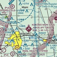
| Sectional chart |
|---|
|
| Airport distance calculator |
|---|
|
|
| Sunrise and sunset |
|---|
|
Times for 29-Dec-2025
| | Local
(UTC-5) | | Zulu
(UTC) |
|---|
| Morning civil twilight | | 07:37 | | 12:37 |
| Sunrise | | 08:08 | | 13:08 |
| Sunset | | 17:24 | | 22:24 |
| Evening civil twilight | | 17:55 | | 22:55 |
|
| Current date and time |
|---|
| Zulu (UTC) | 29-Dec-2025 06:44:19 |
|---|
| Local (UTC-5) | 29-Dec-2025 01:44:19 |
|---|
|
| METAR |
|---|
| KOKK | 290641Z AUTO 27034G42KT 10SM -SN OVC011 M02/M04 A2965 RMK AO2 PK WND 27042/0636 SNB41 P0000 FZRANO $
|
KGUS
8nm NW | 290620Z AUTO 27027G38KT 10SM OVC011 M03/M05 A2963 RMK AO2 SLP039
|
KMZZ
17nm E | 290635Z AUTO 28027G34KT 10SM OVC008 M01/M03 A2964 RMK AO2 T10131033
|
KGGP
18nm NW | 290636Z AUTO 27027G35KT 10SM OVC011 M04/M06 A2968 RMK AO2
|
|
| TAF |
|---|
KGUS
8nm NW | 282200Z 2822/3004 20015G25KT 9999 OVC012 510005 QNH2940INS TEMPO 2823/2901 VRB30G40KT 3200 -TSRA BR BKN008CB OVC010 BECMG 2823/2901 29025G35KT 9999 SCT008 BKN010 OVC020 520005 QNH2944INS BECMG 2907/2908 32025G35KT 4800 -SN BR BKN010 OVC025 620109 520005 QNH2963INS BECMG 2922/2923 29015G25KT 9999 NSW BKN025 BKN050 620258 510005 QNH2996INS TX18/2822Z TNM08/2914Z LAST NO AMDS AFT 2904 NEXT 2914
|
|
| NOTAMs |
|---|
NOTAMs are issued by the DoD/FAA and will open in a separate window not controlled by AirNav.
|
|


