FAA INFORMATION EFFECTIVE 27 NOVEMBER 2025
Location
| FAA Identifier: | IWH |
| Lat/Long: | 40-45-43.1000N 085-47-55.5000W
40-45.718333N 085-47.925000W
40.7619722,-85.7987500
(estimated) |
| Elevation: | 795.6 ft. / 242.5 m (surveyed) |
| Variation: | 03W (1995) |
| From city: | 3 miles SE of WABASH, IN |
| Time zone: | UTC -5 (UTC -4 during Daylight Saving Time) |
| Zip code: | 46992 |
Airport Operations
| Airport use: | Open to the public |
| Activation date: | 05/1958 |
| Control tower: | no |
| ARTCC: | CHICAGO CENTER |
| FSS: | TERRE HAUTE FLIGHT SERVICE STATION |
| NOTAMs facility: | HUF (NOTAM-D service available) |
| Attendance: | NOV-APR MON - SAT 0800-1700, MAY-OCT MON - SAT 0800-1800, MAY - OCT SUN 1230 - 1730, NOV - APR SUN 1230 - 1700 |
| Wind indicator: | lighted |
| Segmented circle: | no |
| Lights: | ACTVT REIL RWY 09 & 27 - CTAF. MIRL RWY 09/27 PRESET LOW INTST; INCR INTST - CTAF. |
| Beacon: | white-green (lighted land airport)
Operates sunset to sunrise. |
Airport Communications
| CTAF/UNICOM: | 122.8 |
| GRISSOM APPROACH: | 121.05 |
| GRISSOM DEPARTURE: | 121.05 |
| WX AWOS-3PT at HHG (16 nm E): | 126.575 (260-454-1927) |
| WX AWOS-3 at MZZ (17 nm S): | 108.6 (765-674-1317) |
| WX AWOS-3PT at OKK (18 nm SW): | 128.675 (765-452-3014) |
- APCH/DEP SVC PRVDD BY CHICAGO ARTCC ON FREQS 121.05 (REMOTED FROM GRISSOM) WHEN GRISSOM APCH CTL CLSD.
Nearby radio navigation aids
| VOR radial/distance | | VOR name | | Freq | | Var |
|---|
| MZZr344/17.0 | | MARION VOR/DME | | 108.60 | | 03W |
| FWAr251/30.6 | | FORT WAYNE VORTAC | | 117.80 | | 06W |
| OLKr208/(32.1) | | WEBSTER LAKE VOR | | 110.40 | | 03W |
| MIEr333/36.5 | | MUNCIE VOR/DME | | 114.40 | | 03W |
Airport Services
| Fuel available: | 100LL JET-A
100LL:AVBL H24 WITH CREDIT CARD. |
| Parking: | tiedowns |
Runway Information
Runway 9/27
| Dimensions: | 4401 x 75 ft. / 1341 x 23 m |
| Surface: | concrete/grooved, in fair condition |
| Weight bearing capacity: | |
| Runway edge lights: | medium intensity |
| RUNWAY 9 | | RUNWAY 27 |
| Latitude: | 40-45.661208N | | 40-45.670573N |
| Longitude: | 085-48.475742W | | 085-47.522630W |
| Elevation: | 793.4 ft. | | 791.7 ft. |
| Traffic pattern: | left
ULTRALIGHT USE R TFC PAT. | | left |
| Runway heading: | 092 magnetic, 089 true | | 272 magnetic, 269 true |
| Markings: | nonprecision, in fair condition | | nonprecision, in fair condition |
| Visual slope indicator: | 2-light PAPI on left (3.00 degrees glide path) | | 2-light PAPI on left (3.00 degrees glide path) |
| Runway end identifier lights: | yes | | yes |
| Touchdown point: | yes, no lights | | yes, no lights |
| Obstructions: | 15 ft. road, 500 ft. from runway, 20:1 slope to clear
+54 FT UNLGTD PLINE 1275 FT FM RWY END; 19:1 OBSTN CLNC SLOPE. | | 53 ft. trees, 1380 ft. from runway, 22:1 slope to clear |
Runway 18/36
| Dimensions: | 1940 x 60 ft. / 591 x 18 m |
| Surface: | asphalt, in good condition |
| Weight bearing capacity: | |
| Runway edge lights: | low intensity |
| RUNWAY 18 | | RUNWAY 36 |
| Latitude: | 40-45.996430N | | 40-45.677055N |
| Longitude: | 085-47.760555W | | 085-47.750758W |
| Elevation: | 790.4 ft. | | 792.8 ft. |
| Traffic pattern: | left | | left |
| Runway heading: | 182 magnetic, 179 true | | 002 magnetic, 359 true |
| Displaced threshold: | 403 ft. | | no |
| Markings: | basic, in fair condition | | basic, in fair condition |
| Touchdown point: | yes, no lights | | yes, no lights |
| Obstructions: | 84 ft. trees, 1440 ft. from runway, 14:1 slope to clear
APCH RATIO 20:1 TO DTHR. | | 60 ft. trees, 650 ft. from runway, 100 ft. right of centerline, 8:1 slope to clear |
Airport Ownership and Management from official FAA records
| Ownership: | Publicly-owned |
| Owner: | WABASH BOAC
283 W. 400 S.
WABASH, IN 46992
Phone 260-563-4705 |
| Manager: | JONATHAN DERBY
283 W. 400 S.
WABASH, IN 46992
Phone 260-563-4705 |
Additional Remarks
| - | FOR CD CTC CHICAGO ARTCC AT 630-906-8921. |
Instrument Procedures
NOTE: All procedures below are presented as PDF files. If you need a reader for these files, you should download the free Adobe Reader.NOT FOR NAVIGATION. Please procure official charts for flight.
FAA instrument procedures published for use from 27 November 2025 at 0901Z to 25 December 2025 at 0900Z.
IAPs - Instrument Approach Procedures |
|---|
| RNAV (GPS) RWY 09 | |
download (210KB) |
| RNAV (GPS) RWY 27 | |
download (201KB) |
| NOTE: Special Take-Off Minimums/Departure Procedures apply | |
download (238KB) |
Other nearby airports with instrument procedures:
I76 - Peru Municipal Airport (16 nm W)
KHHG - Huntington Municipal Airport (16 nm E)
KMZZ - Marion Municipal Airport - McKinney Field (17 nm S)
KGUS - Grissom Air Reserve Base (17 nm SW)
KOKK - Kokomo Municipal Airport (18 nm SW)
|
|

Road maps at:
MapQuest
Bing
Google
| Aerial photo |
|---|
WARNING: Photo may not be current or correct
 Photo taken 05-Aug-2012
looking northeast.
Photo taken 05-Aug-2012
looking northeast.
Do you have a better or more recent aerial photo of Wabash Municipal Airport that you would like to share? If so, please send us your photo.
|
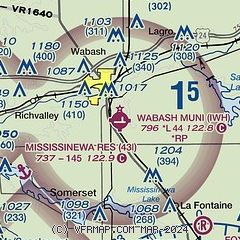
| Sectional chart |
|---|
|
| Airport distance calculator |
|---|
|
|
| Sunrise and sunset |
|---|
|
Times for 02-Dec-2025
| | Local
(UTC-5) | | Zulu
(UTC) |
|---|
| Morning civil twilight | | 07:20 | | 12:20 |
| Sunrise | | 07:50 | | 12:50 |
| Sunset | | 17:15 | | 22:15 |
| Evening civil twilight | | 17:46 | | 22:46 |
|
| Current date and time |
|---|
| Zulu (UTC) | 02-Dec-2025 16:03:02 |
|---|
| Local (UTC-5) | 02-Dec-2025 11:03:02 |
|---|
|
| METAR |
|---|
KMZZ
17nm S | 021535Z AUTO 30004KT 10SM OVC009 M04/M07 A3001 RMK AO2 T10401066
|
KGUS
18nm SW | 021556Z 29007KT 6SM BR OVC007 M04/M06 A3000 RMK AO2A SLP171 T10391061 $
|
KOKK
18nm SW | 021556Z AUTO 27008KT 3SM BR OVC007 M03/M06 A3003 RMK AO2 SLP180 T10331056 FZRANO $
|
KRCR
25nm NW | 021555Z AUTO VRB04KT 3SM BR M05/M06 A3002 RMK AO2
|
KGGP
26nm W | 021536Z AUTO 27006KT 4SM BR OVC007 M05/M07 A3004 RMK AO2
|
KFWA
30nm NE | 021554Z 29005KT 10SM OVC014 M03/M06 A3000 RMK AO2 SLP170 T10281056 $
|
KASW
31nm N | 021535Z AUTO 25004KT 3SM BR OVC006 M03/M05 A3000 RMK AO2 T10401055
|
|
| TAF |
|---|
KGUS
18nm SW | 021400Z 0214/0320 29008KT 9999 BKN007 OVC012 QNH2995INS TEMPO 0214/0222 31006KT 6000 BR SCT007 BKN012 BECMG 0302/0303 VRB06KT 4800 BR BKN007 OVC020 QNH3001INS TEMPO 0303/0309 1600 BR OVC004 BECMG 0311/0312 20010KT 9999 NSW BKN020 BKN100 QNH3002INS TXM04/0220Z TNM09/0308Z
|
|
| NOTAMs |
|---|
NOTAMs are issued by the DoD/FAA and will open in a separate window not controlled by AirNav.
|
|

