FAA INFORMATION EFFECTIVE 02 OCTOBER 2025
Location
| FAA Identifier: | REG |
| Lat/Long: | 30-10-16.9190N 090-56-25.4150W
30-10.281983N 090-56.423583W
30.1713664,-90.9403931
(estimated) |
| Elevation: | 14 ft. / 4.3 m (surveyed) |
| Variation: | 02E (1995) |
| From city: | 2 miles S of GONZALES, LA |
| Time zone: | UTC -5 (UTC -6 during Standard Time) |
| Zip code: | 70737 |
Airport Operations
| Airport use: | Open to the public |
| Activation date: | 05/1992 |
| Control tower: | no |
| ARTCC: | HOUSTON CENTER |
| FSS: | DE RIDDER FLIGHT SERVICE STATION |
| NOTAMs facility: | DRI (NOTAM-D service available) |
| Attendance: | 0800-1700 |
| Wind indicator: | lighted |
| Segmented circle: | yes |
| Lights: | DUSK-DAWN. MIRL RY 17/35 & REIL RYS 17 & 35 PRESET LOW INTST DUSK-DAWN; TO INCR INTST ACTVT - CTAF. |
| Beacon: | white-green (lighted land airport)
Operates sunset to sunrise. |
| International operations: | customs landing rights airport |
Airport Communications
| CTAF/UNICOM: | 123.0 |
| WX AWOS-3PT: | 121.175 (225-644-4014) |
| BATON ROUGE APPROACH: | 133.225 |
| BATON ROUGE DEPARTURE: | 133.225 |
| WX AWOS-3PT at APS (19 nm E): | 125.45 (985-536-1009) |
- APCH/DEP SVC PRVDD BY HOUSTON ARTCC (ZHU) ON FREQS 126.35/338.25 (LAFAYETTE RCAG) WHEN BATON ROUGE APCH CTL (BTR) CLSD.
Nearby radio navigation aids
| VOR radial/distance | | VOR name | | Freq | | Var |
|---|
| RQRr283/18.9 | | RESERVE VOR/DME | | 110.80 | | 02E |
| LSUr130/26.3 | | FIGHTING TIGER VORTAC | | 116.50 | | 06E |
| TBDr347/31.0 | | TIBBY VOR/DME | | 117.15 | | 02E |
Airport Services
| Fuel available: | 100LL JET-A+
100LL:100LL AVBL SELF SVC WITH CREDIT CARD. JET A AVAILABLE AFTER HOURS CALL 225-644-1959 |
| Parking: | hangars and tiedowns |
| Airframe service: | MINOR |
| Powerplant service: | MINOR |
Runway Information
Runway 17/35
| Dimensions: | 5003 x 100 ft. / 1525 x 30 m |
| Surface: | asphalt, in excellent condition |
| Weight bearing capacity: | | Single wheel: | 30.0 | | Double wheel: | 60.0 |
|
| Runway edge lights: | medium intensity |
| RUNWAY 17 | | RUNWAY 35 |
| Latitude: | 30-10.690105N | | 30-09.873868N |
| Longitude: | 090-56.494153W | | 090-56.353017W |
| Elevation: | 12.4 ft. | | 13.6 ft. |
| Traffic pattern: | left | | left |
| Runway heading: | 169 magnetic, 171 true | | 349 magnetic, 351 true |
| Markings: | nonprecision, in good condition | | nonprecision, in good condition |
| Visual slope indicator: | 2-light PAPI on left (3.00 degrees glide path) | | 2-light PAPI on left (3.00 degrees glide path) |
| Runway end identifier lights: | yes | | yes |
| Touchdown point: | yes, no lights | | yes, no lights |
| Obstructions: | 97 ft. trees, 2770 ft. from runway, 96 ft. right of centerline, 26:1 slope to clear | | 51 ft. trees, 1454 ft. from runway, 50 ft. right of centerline, 24:1 slope to clear |
Airport Ownership and Management from official FAA records
| Ownership: | Publicly-owned |
| Owner: | ASCENSION-ST JAMES ARPT &
6255 AIRPORT INDUSTRIAL BLVD
GONZALES, LA 70737
Phone 225-644-1959
TRANSPORTATION AUTHORITY. |
| Manager: | JASON BALL
6255 AIRPORT INDUSTRIAL BLVD
GONZALES, LA 70737
Phone 225-644-1959 |
Additional Remarks
| - | GCO AVBL ON FREQ 135.075 THRU BATON ROUGE APCH & DE RIDDER FSS. |
| - | DEER ON & INVOF ARPT. |
| - | FOR CD IF UNA VIA GCO CTC BATON ROUGE APCH AT 225-354-2142 OR HOUSTON ARTCC AT 281-230-5622. |
| - | CLIMB TO 800 AGL BFR L TURN ON DEP FROM RY 17 FOR NOISE |
Instrument Procedures
NOTE: All procedures below are presented as PDF files. If you need a reader for these files, you should download the free Adobe Reader.NOT FOR NAVIGATION. Please procure official charts for flight.
FAA instrument procedures published for use from 02 October 2025 at 0901Z to 30 October 2025 at 0900z.
IAPs - Instrument Approach Procedures |
|---|
| RNAV (GPS) RWY 17 | |
download (225KB) |
| RNAV (GPS) RWY 35 | |
download (220KB) |
| VOR-A | |
download (191KB) |
| NOTE: Special Alternate Minimums apply | |
download (181KB) |
| NOTE: Special Take-Off Minimums/Departure Procedures apply | |
download (116KB) |
Other nearby airports with instrument procedures:
KAPS - Port of South Louisiana Executive Regional Airport (19 nm E)
KBTR - Baton Rouge Metropolitan Airport, Ryan Field (24 nm NW)
L83 - Thibodaux Municipal Airport (26 nm S)
KHDC - Hammond Northshore Regional Airport (34 nm NE)
KPTN - Harry P Williams Memorial Airport (35 nm SW)
|
|

Road maps at:
MapQuest
Bing
Google
| Aerial photo |
|---|
WARNING: Photo may not be current or correct
 Photo taken 23-Mar-2017
looking north-northwest.
Photo taken 23-Mar-2017
looking north-northwest.
Do you have a better or more recent aerial photo of Louisiana Regional Airport that you would like to share? If so, please send us your photo.
|
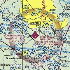
| Sectional chart |
|---|
|
| Airport distance calculator |
|---|
|
|
| Sunrise and sunset |
|---|
|
Times for 12-Oct-2025
| | Local
(UTC-5) | | Zulu
(UTC) |
|---|
| Morning civil twilight | | 06:41 | | 11:41 |
| Sunrise | | 07:05 | | 12:05 |
| Sunset | | 18:36 | | 23:36 |
| Evening civil twilight | | 19:00 | | 24:00 |
|
| Current date and time |
|---|
| Zulu (UTC) | 12-Oct-2025 14:35:24 |
|---|
| Local (UTC-5) | 12-Oct-2025 09:35:24 |
|---|
|
| METAR |
|---|
| KREG | 121415Z AUTO 00000KT 10SM CLR 22/14 A2993 RMK AO2 T02170141
|
KAPS
19nm E | 121415Z AUTO 06004KT 10SM CLR 23/16 A2993 RMK AO2 T02280159
|
|
| TAF |
|---|
KBTR
24nm NW | 121121Z 1212/1312 VRB04KT P6SM SKC= TAF KASD 121121Z 1212/1312 VRB04KT P6SM SKC
|
|
| NOTAMs |
|---|
NOTAMs are issued by the DoD/FAA and will open in a separate window not controlled by AirNav.
|
|


