FAA INFORMATION EFFECTIVE 04 SEPTEMBER 2025
Location
| FAA Identifier: | L83 |
| Lat/Long: | 29-44-52.0510N 090-49-58.4360W
29-44.867517N 090-49.973933W
29.7477919,-90.8328989
(estimated) |
| Elevation: | 9 ft. / 2.7 m (surveyed) |
| Variation: | 02E (1995) |
| From city: | 3 miles S of THIBODAUX, LA |
| Time zone: | UTC -5 (UTC -6 during Standard Time) |
| Zip code: | 70395 |
Airport Operations
| Airport use: | Open to the public |
| Activation date: | 09/1972 |
| Control tower: | no |
| ARTCC: | HOUSTON CENTER |
| FSS: | DE RIDDER FLIGHT SERVICE STATION |
| NOTAMs facility: | DRI (NOTAM-D service available) |
| Attendance: | 0800-1700
FOR ARPT ATND AFT HRS CALL 985-209-4697. |
| Wind indicator: | lighted |
| Segmented circle: | no |
| Lights: | REIL RWY 08/26; MIRL RWY 08/26 PRESET LOW INTST; TO INCR INTST ACTVT - CTAF. |
| Beacon: | white-green (lighted land airport)
Operates sunset to sunrise. |
Airport Communications
| CTAF/UNICOM: | 122.8 |
| NEW ORLEANS APPROACH: | 118.9 |
| NEW ORLEANS DEPARTURE: | 118.9 |
| WX AWOS-3PT at HUM (14 nm SE): | 120.25 (985-876-4055) |
Nearby radio navigation aids
| VOR radial/distance | | VOR name | | Freq | | Var |
|---|
| TBDr356/5.0 | | TIBBY VOR/DME | | 117.15 | | 02E |
| RQRr210/24.0 | | RESERVE VOR/DME | | 110.80 | | 02E |
Airport Services
| Fuel available: | 100LL
100LL:100LL FUEL AVBL BY APPT CALL 985-209-4697 |
| Parking: | tiedowns |
| Airframe service: | MINOR |
| Powerplant service: | MINOR |
| Bottled oxygen: | NONE |
| Bulk oxygen: | NONE |
Runway Information
Runway 8/26
| Dimensions: | 2999 x 75 ft. / 914 x 23 m |
| Surface: | asphalt, in good condition |
| Weight bearing capacity: | |
| Runway edge lights: | medium intensity |
| RUNWAY 8 | | RUNWAY 26 |
| Latitude: | 29-44.839333N | | 29-44.895050N |
| Longitude: | 090-50.256283W | | 090-49.692967W |
| Elevation: | 7.0 ft. | | 9.0 ft. |
| Traffic pattern: | left | | left |
| Runway heading: | 082 magnetic, 084 true | | 262 magnetic, 264 true |
| Displaced threshold: | no | | 90 ft. |
| Markings: | nonprecision, in fair condition | | nonprecision, in fair condition |
| Runway end identifier lights: | yes | | yes |
| Touchdown point: | yes, no lights | | yes, no lights |
| Obstructions: | 79 ft. trees, 637 ft. from runway, 132 ft. right of centerline, 5:1 slope to clear | | 73 ft. trees, 1754 ft. from runway, 130 ft. both sides of centerline, 21:1 slope to clear
APCH RATIO 14:1 TO DSPLCD THR. |
Airport Ownership and Management from official FAA records
| Ownership: | Publicly-owned |
| Owner: | CITY OF THIBODAUX
PO BOX 5418
THIBODAUX, LA 70302-5418
Phone 985-446-7218 |
| Manager: | SARAH ARCENAUX
PO BOX 5418
THIBODAUX, LA 70302-5418
Phone 985-446-7208 |
Additional Remarks
| - | RWY 08/26 AGRICULTURE WASHDOWN PAD 500 FT NORTH OF RWY AT MIDFLD. |
| - | FOR CD CTC NEW ORLEANS APCH AT 504-471-4350. |
| - | TREES 60 FT TALL; 160 FT NORTH AND SOUTH OF CNTRLN PENT THE 7:1 TRSNL SLP RWY 08. |
| - | WILDLIFE ON OR NEAR THE RWY SAFETY AREA |
| - | CTC ARPT MGR FOR DSNGD RAMP SPACE FOR PUB USE AT ARPT |
Instrument Procedures
NOTE: All procedures below are presented as PDF files. If you need a reader for these files, you should download the free Adobe Reader.NOT FOR NAVIGATION. Please procure official charts for flight.
FAA instrument procedures published for use from 04 September 2025 at 0901Z to 02 October 2025 at 0900z.
IAPs - Instrument Approach Procedures |
|---|
| RNAV (GPS) RWY 08 | |
download (162KB) |
| RNAV (GPS) RWY 08 | |
download (162KB) |
| NOTE: Special Take-Off Minimums/Departure Procedures apply | |
download (114KB) |
Other nearby airports with instrument procedures:
KHUM - Houma-Terrebonne Airport (14 nm SE)
KAPS - Port of South Louisiana Executive Regional Airport (24 nm NE)
KREG - Louisiana Regional Airport (26 nm N)
KPTN - Harry P Williams Memorial Airport (26 nm W)
KMSY - Louis Armstrong New Orleans International Airport (33 nm NE)
|
|

Road maps at:
MapQuest
Bing
Google
| Aerial photo |
|---|
WARNING: Photo may not be current or correct

Do you have a better or more recent aerial photo of Thibodaux Municipal Airport that you would like to share? If so, please send us your photo.
|
| Sectional chart |
|---|
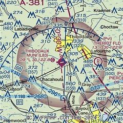
|
| Airport distance calculator |
|---|
|
|
| Sunrise and sunset |
|---|
|
Times for 22-Sep-2025
| | Local
(UTC-5) | | Zulu
(UTC) |
|---|
| Morning civil twilight | | 06:29 | | 11:29 |
| Sunrise | | 06:53 | | 11:53 |
| Sunset | | 18:59 | | 23:59 |
| Evening civil twilight | | 19:23 | | 00:23 |
|
| Current date and time |
|---|
| Zulu (UTC) | 23-Sep-2025 03:42:49 |
|---|
| Local (UTC-5) | 22-Sep-2025 22:42:49 |
|---|
|
| METAR |
|---|
KHUM
14nm SE | 230315Z AUTO 09003KT 10SM CLR 24/22 A2996 RMK AO2 T02410224 PWINO
|
KAPS
24nm NE | 230315Z AUTO 00000KT 7SM CLR 23/23 A2996 RMK AO2 T02330230
|
KPTN
25nm W | 230256Z AUTO 07003KT 10SM CLR 24/24 A2995 RMK AO2 SLP142 T02440239 53010 $
|
KREG
26nm N | 230315Z AUTO 00000KT 7SM CLR 24/22 A2994 RMK AO2 T02350222
|
|
| TAF |
|---|
KHUM
14nm SE | 221729Z 2218/2318 16008KT P6SM SCT035 SCT100 PROB30 2218/2221 VRB15KT 4SM -TSRA BKN025CB BKN026 FM230100 VRB03KT P6SM FEW030 FEW250 FM231500 17007KT P6SM FEW030 FEW100
|
|
| NOTAMs |
|---|
NOTAMs are issued by the DoD/FAA and will open in a separate window not controlled by AirNav.
|
|

