FAA INFORMATION EFFECTIVE 15 MAY 2025
Location
| FAA Identifier: | SVE |
| Lat/Long: | 40-22-32.5000N 120-34-21.7000W
40-22.541667N 120-34.361667W
40.3756944,-120.5726944
(estimated) |
| Elevation: | 4149.1 ft. / 1264.6 m (surveyed) |
| Variation: | 17E (1985) |
| From city: | 5 miles SE of SUSANVILLE, CA |
| Time zone: | UTC -7 (UTC -8 during Standard Time) |
| Zip code: | 96130 |
Airport Operations
| Airport use: | Open to the public |
| Activation date: | 04/1940 |
| Control tower: | no |
| ARTCC: | OAKLAND CENTER |
| FSS: | RENO FLIGHT SERVICE STATION |
| NOTAMs facility: | SVE (NOTAM-D service available) |
| Attendance: | 0800-1700 |
| Pattern altitude: | 4949.1 ft. MSL |
| Wind indicator: | lighted |
| Segmented circle: | yes |
| Lights: | ACTVT MIRL RWY 11/29 - CTAF |
| Beacon: | white-green (lighted land airport)
Operates sunset to sunrise. |
Airport Communications
| CTAF/UNICOM: | 122.8 |
| WX AWOS-3: | 133.8 (530-257-0315) |
- APCH/DEP CTL SVC PRVDD BY OAKLAND ARTCC (ZOA) ON FREQS 128.8/285.5 (RENO RCAG).
Nearby radio navigation aids
| VOR radial/distance | | VOR name | | Freq | | Var |
|---|
| AHCr272/20.3 | | AMEDEE VOR/DME | | 109.00 | | 17E |
Airport Services
| Fuel available: | 100LL JET-A |
| Parking: | tiedowns |
| Airframe service: | MAJOR |
| Powerplant service: | MAJOR |
| Bottled oxygen: | NONE |
| Bulk oxygen: | NONE |
Runway Information
Runway 11/29
| Dimensions: | 4051 x 75 ft. / 1235 x 23 m |
| Surface: | asphalt/grooved, in good condition |
| Weight bearing capacity: | | Single wheel: | 15.0, LTD TO 12000 LBS BY AMGR. |
|
| Runway edge lights: | medium intensity |
| RUNWAY 11 | | RUNWAY 29 |
| Latitude: | 40-22.787520N | | 40-22.367912N |
| Longitude: | 120-34.649087W | | 120-33.971040W |
| Elevation: | 4147.1 ft. | | 4122.2 ft. |
| Traffic pattern: | left | | right |
| Runway heading: | 112 magnetic, 129 true | | 292 magnetic, 309 true |
| Markings: | nonprecision, in fair condition | | nonprecision, in fair condition |
| Visual slope indicator: | 2-light PAPI on left (3.00 degrees glide path)
DOES NOT PROVIDE OBSTRUCTION CLEARANCE BYD 6.2 NM FROM THR. | | 2-light PAPI on left (4.00 degrees glide path) |
| Runway end identifier lights: | no | | no |
| Touchdown point: | yes, no lights | | yes, no lights |
| Obstructions: | 70 ft. trees, marked, 1650 ft. from runway, 125 ft. both sides of centerline, 20:1 slope to clear
POWERLINE ORANGE BALLS BELOW TREE LINE PARTIALLY OBSCURED | | none |
Helipad H1
| Dimensions: | 120 x 120 ft. / 37 x 37 m |
| Surface: | asphalt, in good condition |
| Latitude: | 40-22.599667N | | |
| Longitude: | 120-34.539333W | | |
| Elevation: | 4150.0 ft. | | |
| Traffic pattern: | left | | left |
| Markings: | , in fair condition | | |
Runway 7/25
| Dimensions: | 2180 x 60 ft. / 664 x 18 m |
| Surface: | dirt, in fair condition |
| RUNWAY 7 | | RUNWAY 25 |
| Latitude: | 40-22.472263N | | 40-22.475410N |
| Longitude: | 120-34.692670W | | 120-34.223423W |
| Elevation: | 4149.1 ft. | | 4130.3 ft. |
| Traffic pattern: | left | | left |
| Runway heading: | 072 magnetic, 089 true | | 252 magnetic, 269 true |
| Markings: | none | | none |
| Runway end identifier lights: | no | | no |
| Touchdown point: | yes, no lights | | yes, no lights |
| Obstructions: | 5 ft. fence, 60 ft. from runway, 12:1 slope to clear | | none |
Airport Ownership and Management from official FAA records
| Ownership: | Publicly-owned |
| Owner: | CITY OF SUSANVILLE
66 N. LASSEN ST.
SUSANVILLE, CA 96130
Phone 530-257-1050 |
| Manager: | STEVE DATAMA
471-920 JOHNSTONVILLE ROAD #10
SUSANVILLE, CA 96130
Phone 530-257-2030
SVE@FRONTIERNET.NET |
Additional Remarks
| - | FOR CD CTC OAKLAND ARTCC AT 510-745-3380. |
| - | COLD TEMPERATURE AIRPORT. ALTITUDE CORRECTION REQUIRED AT OR BELOW -15C. |
Instrument Procedures
NOTE: All procedures below are presented as PDF files. If you need a reader for these files, you should download the free Adobe Reader.NOT FOR NAVIGATION. Please procure official charts for flight.
FAA instrument procedures published for use from 15 May 2025 at 0901Z to 13 June 2025 at 0900z.
IAPs - Instrument Approach Procedures |
|---|
| RNAV (GPS) RWY 29 | |
download (215KB) |
| RNAV (GPS)-A | |
download (199KB) |
| NOTE: Special Alternate Minimums apply | |
download (137KB) |
|
|---|
| AMEDEE ONE (OBSTACLE) | |
download (142KB) |
| NOTE: Special Take-Off Minimums/Departure Procedures apply | |
download (128KB) |
Other nearby airports with instrument procedures:
KAHC - Amedee Army Airfield (20 nm E)
O05 - Rogers Field Airport (31 nm W)
O02 - Nervino Airport (35 nm S)
KRTS - Reno/Stead Airport (53 nm SE)
KRNO - Reno/Tahoe International Airport (64 nm SE)
|
|

Road maps at:
MapQuest
Bing
Google
| Aerial photo |
|---|
WARNING: Photo may not be current or correct
 Photo taken 13-Nov-2010
looking southwest.
Photo taken 13-Nov-2010
looking southwest.
Do you have a better or more recent aerial photo of Susanville Municipal Airport that you would like to share? If so, please send us your photo.
|
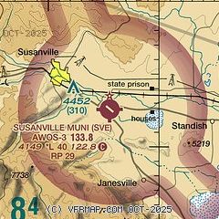
| Sectional chart |
|---|
|
| Airport distance calculator |
|---|
|
|
| Sunrise and sunset |
|---|
|
Times for 25-May-2025
| | Local
(UTC-7) | | Zulu
(UTC) |
|---|
| Morning civil twilight | | 05:07 | | 12:07 |
| Sunrise | | 05:39 | | 12:39 |
| Sunset | | 20:19 | | 03:19 |
| Evening civil twilight | | 20:51 | | 03:51 |
|
| Current date and time |
|---|
| Zulu (UTC) | 26-May-2025 04:39:37 |
|---|
| Local (UTC-7) | 25-May-2025 21:39:37 |
|---|
|
| METAR |
|---|
| KSVE | 260415Z AUTO 23015G21KT 10SM CLR 19/M01 A3002 RMK A01 P000
|
|
| NOTAMs |
|---|
NOTAMs are issued by the DoD/FAA and will open in a separate window not controlled by AirNav.
|
|


