FAA INFORMATION EFFECTIVE 27 NOVEMBER 2025
Location
| FAA Identifier: | TOI |
| Lat/Long: | 31-51-36.0000N 086-00-50.0000W
31-51.600000N 086-00.833333W
31.8600000,-86.0138889
(estimated) |
| Elevation: | 397.2 ft. / 121.1 m (surveyed) |
| Variation: | 04W (2015) |
| From city: | 4 miles NW of TROY, AL |
| Time zone: | UTC -6 (UTC -5 during Daylight Saving Time) |
| Zip code: | 36079 |
Airport Operations
| Airport use: | Open to the public |
| Activation date: | 12/1944 |
| Control tower: | yes |
| ARTCC: | JACKSONVILLE CENTER |
| FSS: | ANNISTON FLIGHT SERVICE STATION |
| NOTAMs facility: | TOI (NOTAM-D service available) |
| Attendance: | 0800-1700
PPR FOR NIGHT CANCELLED |
| Wind indicator: | lighted |
| Segmented circle: | no |
| Lights: | ACTVT PAPI RWY 07; MIRL RWY 07/25, 14/32 - CTAF. |
| Beacon: | white-green (lighted land airport)
Operates sunset to sunrise. |
Airport Communications
| CTAF: | 124.3 |
| UNICOM: | 122.8 |
| ATIS: | 120.925 |
| WX ASOS: | PHONE 334-566-3081 |
| TROY GROUND: | 121.9 294.7 [1400-2200Z++ MON-FRI EXCP HOLS.] |
| TROY TOWER: | 124.3 306.9 [1400-2200Z++ MON-FRI EXCP HOLS.] |
| CAIRNS APPROACH: | 121.1 |
| CAIRNS DEPARTURE: | 121.1 |
| EMERG: | 121.5 243.0 |
- APCH/DEP SVC PRVDD BY ATLANTA ARTCC ON FREQS 120.55/270.25 (MONTGOMERY RCAG) WHEN CAIRNS APCH/DEP CLSD.
- OPERATES NON-CONTINOUSLY.
Nearby radio navigation aids
| VOR radial/distance | | VOR name | | Freq | | Var |
|---|
| MGMr141/26.7 | | MONTGOMERY VORTAC | | 112.10 | | 03E |
| EDNr353/(34.3) | | ENTERPRISE VOR | | 116.60 | | 03W |
| HEYr331/(34.5) | | HANCHEY VOR | | 110.60 | | 03W |
| OZRr340/38.4 | | CAIRNS VOR/DME | | 111.20 | | 03W |
| NDB name | | Hdg/Dist | | Freq | | Var | | ID |
|---|
| BLOOD | | 074/5.0 | | 365 | | 04W | | TOI | - --- .. |
| BOLL WEEVIL | | 000/31.3 | | 352 | | 03W | | BVG | -... ...- --. |
| LOWE | | 338/32.9 | | 269 | | 03W | | LOR | .-.. --- .-. |
Airport Services
| Fuel available: | 100LL JET-A+
100LL:FUEL AVBL 0800-1700 MON-SUN; AFTER HRS CALL 334-566-3470. CONTRACT MILITARY FUEL. |
| Parking: | hangars and tiedowns |
| Airframe service: | MAJOR |
| Powerplant service: | MAJOR |
| Bottled oxygen: | NONE |
| Bulk oxygen: | NONE |
Runway Information
Runway 7/25
| Dimensions: | 6197 x 100 ft. / 1889 x 30 m |
| Surface: | asphalt, in excellent condition |
| Weight bearing capacity: | | Single wheel: | 24.0 | | Double wheel: | 80.0 | | Double tandem: | 140.0 |
|
| Runway edge lights: | medium intensity |
| Runway edge markings: | MARKINGS FADED. |
| RUNWAY 7 | | RUNWAY 25 |
| Latitude: | 31-51.438600N | | 31-51.796230N |
| Longitude: | 086-01.585462W | | 086-00.463667W |
| Elevation: | 380.7 ft. | | 393.6 ft. |
| Traffic pattern: | left | | left |
| Runway heading: | 073 magnetic, 069 true | | 254 magnetic, 250 true |
| Markings: | nonprecision, in good condition | | precision, in good condition |
| Visual slope indicator: | 4-light PAPI on left (3.00 degrees glide path) | | |
| Touchdown point: | yes, no lights | | yes, no lights |
| Instrument approach: | ILS/DME | | |
| Obstructions: | 23 ft. tree, 811 ft. from runway, 298 ft. right of centerline, 26:1 slope to clear | | 29 ft. tree, 776 ft. from runway, 209 ft. left of centerline, 19:1 slope to clear |
Runway 14/32
| Dimensions: | 5024 x 100 ft. / 1531 x 30 m
25 FT PAVED SHOULDERS. |
| Surface: | asphalt, in poor condition
WIDESPREAD BLOCK CRACKING, RAVELING, AND VEGETATION. |
| Weight bearing capacity: | | Single wheel: | 24.0 | | Double wheel: | 80.0 | | Double tandem: | 140.0 |
|
| Runway edge lights: | medium intensity
MIRL LCTD 35 FT FM RWY EDGE; THLD LGTS LCTD 17 FT FM RWY 32 END. |
| Runway edge markings: | RWY MRKNGS SVRLY FADED |
| RUNWAY 14 | | RUNWAY 32 |
| Latitude: | 31-51.910562N | | 31-51.249532N |
| Longitude: | 086-00.890878W | | 086-00.305485W |
| Elevation: | 397.2 ft. | | 365.1 ft. |
| Traffic pattern: | left | | left |
| Runway heading: | 147 magnetic, 143 true | | 327 magnetic, 323 true |
| Markings: | nonprecision, in poor condition | | nonprecision, in poor condition |
| Touchdown point: | yes, no lights | | yes, no lights |
| Obstructions: | 77 ft. tree, 1039 ft. from runway, 295 ft. right of centerline, 10:1 slope to clear | | 79 ft. trees, 1126 ft. from runway, 361 ft. right of centerline, 11:1 slope to clear |
Airport Ownership and Management from official FAA records
| Ownership: | Publicly-owned |
| Owner: | CITY OF TROY
PO BOX 549
TROY, AL 36081
Phone 334-566-0177 |
| Manager: | TRENT CRAWFORD
301 CAMPBELL FIELD ROAD
TROY, AL 36079
Phone 334-566-3470 |
Additional Remarks
| - | EXTSV HEL AND FLT TRNG OPS INVOF ARPT 0630-1700 MON-FRI EXCP HOL. |
| - | NO RUNNING LNDGS ON RWY OR TWY BY SKID-EQUIPPED HEL. |
| - | CTC CAIRNS AAF FOR FCST 0600Z++ MON-0700Z++ SAT, EXC HOL. WX OBSN VIS RSTD NE-E DUE TO HGR. REMOTE BRIEFING SVC AVBL 26 OWS, BARKSDALE AFB, DSN 331-2651, C866-223-9328 (TOLL FREE) OR HTTPS://OWS.BARKSDALE.AF.MIL. |
| - | NO ARR/DEP TO/FROM N HELI OVR FBO RAMP. |
| - | FOR CD WHEN ATCT CLSD CTC CAIRNS APCH AT 334-255-8402; FOR CD WHEN CAIRNS APCH CLSD CTC ATLANTA ARTCC AT 770-210-7692. |
Instrument Procedures
NOTE: All procedures below are presented as PDF files. If you need a reader for these files, you should download the free Adobe Reader.NOT FOR NAVIGATION. Please procure official charts for flight.
FAA instrument procedures published for use from 27 November 2025 at 0901Z to 25 December 2025 at 0900Z.
IAPs - Instrument Approach Procedures |
|---|
| ILS OR LOC RWY 07 | |
download (298KB) |
| RNAV (GPS) RWY 07 | |
download (205KB) |
| RNAV (GPS) RWY 14 | |
download (210KB) |
| RNAV (GPS) RWY 25 | |
download (246KB) |
| RNAV (GPS) RWY 32 | |
download (217KB) |
| NDB RWY 07 | |
download (224KB) |
| NOTE: Special Alternate Minimums apply | |
download (160KB) |
| NOTE: Special Take-Off Minimums/Departure Procedures apply | |
download (490KB) |
Other nearby airports with instrument procedures:
07A - Franklin Field Airport (21 nm NE)
11A - Clayton Municipal Airport (27 nm E)
KPRN - Mac Crenshaw Memorial Airport (30 nm W)
71J - Ozark/Blackwell Field Airport (33 nm SE)
KMGM - Montgomery Regional Airport (Dannelly Field) (33 nm NW)
|
|

Road maps at:
MapQuest
Bing
Google
| Aerial photo |
|---|
WARNING: Photo may not be current or correct
 Photo courtesy of AirNav, LLC
Photo taken 05-May-2011
looking south.
Photo courtesy of AirNav, LLC
Photo taken 05-May-2011
looking south.
Do you have a better or more recent aerial photo of Troy Municipal Airport at N Kenneth Campbell Field that you would like to share? If so, please send us your photo.
|
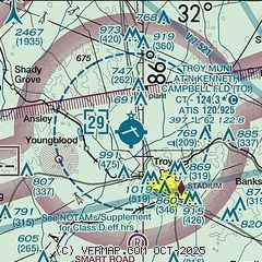
| Sectional chart |
|---|
|
| Airport distance calculator |
|---|
|
|
| Sunrise and sunset |
|---|
|
Times for 04-Dec-2025
| | Local
(UTC-6) | | Zulu
(UTC) |
|---|
| Morning civil twilight | | 06:03 | | 12:03 |
| Sunrise | | 06:30 | | 12:30 |
| Sunset | | 16:39 | | 22:39 |
| Evening civil twilight | | 17:05 | | 23:05 |
|
| Current date and time |
|---|
| Zulu (UTC) | 05-Dec-2025 03:23:11 |
|---|
| Local (UTC-6) | 04-Dec-2025 21:23:11 |
|---|
|
| METAR |
|---|
| KTOI | 050253Z AUTO 04003KT 5SM BR OVC003 07/07 A3007 RMK AO2 SLP184 60003 T00720067 58008
|
|
| NOTAMs |
|---|
NOTAMs are issued by the DoD/FAA and will open in a separate window not controlled by AirNav.
|
|

