FAA INFORMATION EFFECTIVE 27 NOVEMBER 2025
Location
| FAA Identifier: | 11A |
| Lat/Long: | 31-52-59.9680N 085-29-06.8090W
31-52.999467N 085-29.113483W
31.8833244,-85.4852247
(estimated) |
| Elevation: | 434.9 ft. / 132.6 m (surveyed) |
| Variation: | 04W (2015) |
| From city: | 2 miles W of CLAYTON, AL |
| Time zone: | UTC -6 (UTC -5 during Daylight Saving Time) |
| Zip code: | 36016 |
Airport Operations
| Airport use: | Open to the public |
| Activation date: | 02/1970 |
| Control tower: | no |
| ARTCC: | JACKSONVILLE CENTER |
| FSS: | ANNISTON FLIGHT SERVICE STATION |
| NOTAMs facility: | ANB (NOTAM-D service available) |
| Attendance: | UNATNDD |
| Wind indicator: | lighted |
| Segmented circle: | yes |
| Lights: | ACTVT PAPI RWY 10 & 28; HIRL RWY 10/28 - CTAF. |
| Beacon: | white-green (lighted land airport)
Operates sunset to sunrise. |
Airport Communications
| CTAF: | 122.9 |
| CAIRNS APPROACH: | 121.1 |
| CAIRNS DEPARTURE: | 121.1 |
| WX ASOS at EUF (19 nm E): | 128.325 (334-232-0003) |
- APCH/DEP SVC PRVDD BY ATLANTA ARTCC ON FREQS 120.55/270.25 (MONTGOMERY RCAG) WHEN CAIRNS APCH/DEP CLSD.
Nearby radio navigation aids
| VOR radial/distance | | VOR name | | Freq | | Var |
|---|
| EUFr255/18.5 | | EUFAULA VOR/DME | | 109.20 | | 02E |
| HEYr019/(31.7) | | HANCHEY VOR | | 110.60 | | 03W |
| RRSr354/36.0 | | WIREGRASS VORTAC | | 111.60 | | 02E |
| LSFr228/36.8 | | LAWSON VOR/DME | | 111.40 | | 05W |
| OZRr021/38.9 | | CAIRNS VOR/DME | | 111.20 | | 03W |
| NDB name | | Hdg/Dist | | Freq | | Var | | ID |
|---|
| BLOOD | | 088/31.8 | | 365 | | 04W | | TOI | - --- .. |
| LOWE | | 026/34.0 | | 269 | | 03W | | LOR | .-.. --- .-. |
Airport Services
| Parking: | tiedowns |
| Airframe service: | NONE |
| Powerplant service: | NONE |
| Bottled oxygen: | NONE |
| Bulk oxygen: | NONE |
Runway Information
Runway 10/28
| Dimensions: | 5010 x 80 ft. / 1527 x 24 m |
| Surface: | asphalt/aggregate friction seal coat, in fair condition |
| Runway edge lights: | high intensity |
| RUNWAY 10 | | RUNWAY 28 |
| Latitude: | 31-53.047310N | | 31-52.951598N |
| Longitude: | 085-29.594240W | | 085-28.632727W |
| Elevation: | 422.0 ft. | | 434.3 ft. |
| Traffic pattern: | left | | left |
| Runway heading: | 101 magnetic, 097 true | | 281 magnetic, 277 true |
| Displaced threshold: | 278 ft. | | no |
| Markings: | nonprecision, in fair condition | | nonprecision, in fair condition |
| Visual slope indicator: | 2-light PAPI on left (3.20 degrees glide path) | | 2-light PAPI on left (3.75 degrees glide path) |
| Runway end identifier lights: | yes | | yes |
| Touchdown point: | yes, no lights | | yes, no lights |
| Obstructions: | 53 ft. tree, 1106 ft. from runway, 178 ft. right of centerline, 17:1 slope to clear
APCH RATIO 19:1 FM DSPLCD THR. | | 85 ft. tree, 1203 ft. from runway, 293 ft. right of centerline, 11:1 slope to clear |
Airport Ownership and Management from official FAA records
| Ownership: | Publicly-owned |
| Owner: | CITY OF CLAYTON
PO BOX 385
CLAYTON, AL 36016
Phone 334-775-9176 |
| Manager: | DARRELL BYRD
25 ROBERTSON AIRPORT RD.
CLAYTON, AL 36016
Phone 334-232-1028 |
Additional Remarks
| - | DEER AND BIRD ACTVTY ON AND INVOF RWY. |
| - | FOR CD CTC CAIRNS APCH AT 334-255-8402; FOR CD WHEN CAIRNS APCH CLSD CTC ATLANTA ARTCC AT 770-210-7692. |
Instrument Procedures
NOTE: All procedures below are presented as PDF files. If you need a reader for these files, you should download the free Adobe Reader.NOT FOR NAVIGATION. Please procure official charts for flight.
FAA instrument procedures published for use from 27 November 2025 at 0901Z to 25 December 2025 at 0900Z.
IAPs - Instrument Approach Procedures |
|---|
| RNAV (GPS) RWY 10 | |
download (202KB) |
| RNAV (GPS) RWY 28 | |
download (197KB) |
| NOTE: Special Take-Off Minimums/Departure Procedures apply | |
download (512KB) |
Other nearby airports with instrument procedures:
KEUF - Weedon Field Airport (19 nm E)
07A - Franklin Field Airport (24 nm NW)
KTOI - Troy Municipal Airport at N Kenneth Campbell Field (27 nm W)
71J - Ozark/Blackwell Field Airport (28 nm S)
KHDL - Headland Municipal Airport (32 nm S)
|
|

Road maps at:
MapQuest
Bing
Google
| Aerial photo |
|---|
WARNING: Photo may not be current or correct
 Photo courtesy of Eddie Yell / Boyd Bros Transportation
Photo taken 22-Mar-2009
Photo courtesy of Eddie Yell / Boyd Bros Transportation
Photo taken 22-Mar-2009
Do you have a better or more recent aerial photo of Clayton Municipal Airport that you would like to share? If so, please send us your photo.
|
| Sectional chart |
|---|
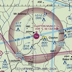
|
| Airport distance calculator |
|---|
|
|
| Sunrise and sunset |
|---|
|
Times for 08-Dec-2025
| | Local
(UTC-6) | | Zulu
(UTC) |
|---|
| Morning civil twilight | | 06:04 | | 12:04 |
| Sunrise | | 06:31 | | 12:31 |
| Sunset | | 16:37 | | 22:37 |
| Evening civil twilight | | 17:04 | | 23:04 |
|
| Current date and time |
|---|
| Zulu (UTC) | 08-Dec-2025 15:46:12 |
|---|
| Local (UTC-6) | 08-Dec-2025 09:46:12 |
|---|
|
| METAR |
|---|
KEUF
19nm E | 081458Z AUTO 31008KT 10SM OVC006 08/07 A3011 RMK AO1 RAB16E26 SLP196 P0000 60000 T00780067 53020
|
KTOI
27nm W | 081515Z AUTO 34012G21KT 10SM BKN010 08/06 A3015 RMK AO2 T00830056
|
KHEY
33nm S | 081527Z AUTO 34008KT 10SM OVC007 10/08 A3011 RMK AO2 SLP199 $
|
KDHN
34nm S | 081540Z 32011KT 10SM OVC010 09/07 A3014 RMK AO1 CIG 007V014 T00940072
|
KLOR
35nm SW | 081535Z AUTO 34006KT 10SM OVC010 10/08 A3011 RMK AO2 SLP180
|
KLSF
36nm NE | 081515Z AUTO 32009KT 10SM OVC010 10/08 A3009 RMK AO2 CIG 007V010 SLP195
|
KSXS
36nm SW | 081530Z AUTO 02007KT 10SM BKN008 OVC012 09/08 A3011 RMK AO2 BKN V OVC SLP199 $
|
|
| NOTAMs |
|---|
NOTAMs are issued by the DoD/FAA and will open in a separate window not controlled by AirNav.
|
|

