FAA INFORMATION EFFECTIVE 09 JULY 2026
Location
| FAA Identifier: | UBS |
| Lat/Long: | 33-27-55.2000N 088-22-50.7000W
33-27.920000N 088-22.845000W
33.4653333,-88.3807500
(estimated) |
| Elevation: | 188.1 ft. / 57.3 m (surveyed) |
| Variation: | 03W (2020) |
| From city: | 3 miles SE of COLUMBUS, MS |
| Time zone: | UTC -5 (UTC -6 during Standard Time) |
| Zip code: | 39702 |
Airport Operations
| Airport use: | Open to the public |
| Activation date: | 12/1952 |
| Control tower: | no |
| ARTCC: | MEMPHIS CENTER |
| FSS: | GREENWOOD FLIGHT SERVICE STATION |
| NOTAMs facility: | GWO (NOTAM-D service available) |
| Attendance: | MON-FRI 0800-1800, ALL SAT-SUN ON CALL |
| Wind indicator: | lighted |
| Segmented circle: | yes |
| Lights: | MIRL RWY 18/36 OPR DUSK - 2200; AFT 2200 ACTVT - CTAF. PAPI RWY 18 & 36 OPR CONSLY. |
| Beacon: | white-green (lighted land airport)
Operates sunset to sunrise. |
Airport Communications
| CTAF/UNICOM: | 122.8 |
| COLUMBUS APPROACH: | 135.6 |
| COLUMBUS DEPARTURE: | 135.6 |
| WX AWOS-3PT at GTR (11 nm W): | 126.375 (662-328-7798) |
| WX ASOS at CBM (11 nm N): | 354.6 |
- APCH/DEP SVC PRVDD BY MEMPHIS ARTCC (COLUMBUS RCAG) ON FREQS 127.1/269.4 WHEN COLUMBUS APCH CTL CLSD.
Nearby radio navigation aids
| VOR radial/distance | | VOR name | | Freq | | Var |
|---|
| IGBr096/6.8 | | BIGBEE VORTAC | | 116.20 | | 04E |
| CBMr165/11.0 | | CALEDONIA VORTAC | | 115.20 | | 00E |
Airport Services
| Fuel available: | 100LL JET-A+
100LL:FUEL AVBL 24 HRS WITH CREDIT CARD. |
| Parking: | hangars and tiedowns |
| Airframe service: | MINOR |
| Powerplant service: | MINOR |
| Bottled oxygen: | NONE |
| Bulk oxygen: | NONE |
Runway Information
Runway 18/36
| Dimensions: | 4503 x 100 ft. / 1373 x 30 m |
| Surface: | asphalt, in excellent condition |
| Weight bearing capacity: | | Single wheel: | 40.0 | | Double wheel: | 70.0 | | Double tandem: | 120.0 |
|
| Runway edge lights: | medium intensity |
| RUNWAY 18 | | RUNWAY 36 |
| Latitude: | 33-28.291402N | | 33-27.549092N |
| Longitude: | 088-22.853945W | | 088-22.836555W |
| Elevation: | 188.0 ft. | | 184.6 ft. |
| Traffic pattern: | left | | left |
| Runway heading: | 182 magnetic, 179 true | | 002 magnetic, 359 true |
| Markings: | nonprecision, in good condition | | nonprecision, in good condition |
| Visual slope indicator: | 2-light PAPI on left (3.00 degrees glide path) | | 2-light PAPI on left (3.00 degrees glide path)
OTS UFN. |
| Touchdown point: | yes, no lights | | yes, no lights |
| Obstructions: | 68 ft. trees, 2510 ft. from runway, 300 ft. left of centerline, 34:1 slope to clear | | 67 ft. trees, 2075 ft. from runway, 27:1 slope to clear |
Airport Ownership and Management from official FAA records
| Ownership: | Publicly-owned |
| Owner: | CITY OF COLUMBUS & LOWNDES COUNTY
523 MAIN ST, PO BOX 1408
COLUMBUS, MS 39703
Phone 662-328-7021 |
| Manager: | DAN DUSTON
368 FABRITEK DR
COLUMBUS, MS 39702
Phone 662-251-4650 |
Additional Remarks
| - | FOR CD CTC MEMPHIS ARTCC AT 901-368-8453/8449. |
| - | COURTESY CAR AVBL. |
Instrument Procedures
NOTE: All procedures below are presented as PDF files. If you need a reader for these files, you should download the free Adobe Reader.NOT FOR NAVIGATION. Please procure official charts for flight.
FAA instrument procedures published for use from 09 July 2026 at 0901Z to 06 August 2026 at 0900Z.
IAPs - Instrument Approach Procedures |
|---|
| RNAV (GPS) RWY 18 **CHANGED** | |
download (217KB) |
| RNAV (GPS) RWY 36 **CHANGED** | |
download (222KB) |
| VOR-A **CHANGED** | |
download (163KB) |
| NOTE: Special Take-Off Minimums/Departure Procedures apply | |
download (116KB) |
Other nearby airports with instrument procedures:
KGTR - Golden Triangle Regional Airport (11 nm W)
KCBM - Columbus Air Force Base (11 nm N)
M51 - Oktibbeha Airport (15 nm W)
M83 - McCharen Field Airport (16 nm NW)
3M8 - North Pickens Airport (19 nm E)
|
|

Road maps at:
MapQuest
Bing
Google
| Aerial photo |
|---|
WARNING: Photo may not be current or correct
 Photo by Dan Duston
Taken in the Summer of 2019
looking north.
Photo by Dan Duston
Taken in the Summer of 2019
looking north.
Do you have a better or more recent aerial photo of Columbus-Lowndes County Airport that you would like to share? If so, please send us your photo.
|
| Sectional chart |
|---|
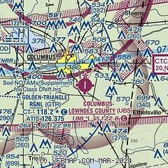
|
| Airport distance calculator |
|---|
|
|
| Sunrise and sunset |
|---|
|
Times for 28-Jul-2026
| | Local
(UTC-5) | | Zulu
(UTC) |
|---|
| Morning civil twilight | | 05:37 | | 10:37 |
| Sunrise | | 06:04 | | 11:04 |
| Sunset | | 19:56 | | 00:56 |
| Evening civil twilight | | 20:23 | | 01:23 |
|
| Current date and time |
|---|
| Zulu (UTC) | 28-Jul-2026 21:47:05 |
|---|
| Local (UTC-5) | 28-Jul-2026 16:47:05 |
|---|
|
| METAR |
|---|
KGTR
9nm W | 282056Z 25009KT 210V290 10SM CLR 37/23 A2984 RMK AO2 SLP101 T03670233 58018 $
|
KCBM
11nm N | 282055Z 27011KT 10SM FEW050 SCT120 37/24 A2978 RMK AO2A SLP084 T03660237 57016 $
|
|
| TAF |
|---|
KGTR
9nm W | 281720Z 2818/2918 29008KT P6SM FEW250
|
KCBM
11nm N | 281700Z 2817/2923 29006KT 9999 FEW150 QNH2982INS BECMG 2820/2821 23006KT 9999 FEW040 SCT080 QNH2980INS BECMG 2913/2914 24006KT 9999 VCTS SCT020 BKN050CB QNH2979INS TX37/2820Z TN26/2911Z
|
|
| NOTAMs |
|---|
NOTAMs are issued by the DoD/FAA and will open in a separate window not controlled by AirNav.
|
|

