FAA INFORMATION EFFECTIVE 11 JUNE 2026
Location
| FAA Identifier: | VNY |
| Lat/Long: | 34-12-35.3000N 118-29-23.9000W
34-12.588333N 118-29.398333W
34.2098056,-118.4899722
(estimated) |
| Elevation: | 802.1 ft. / 244.5 m (surveyed) |
| Variation: | 12E (2020) |
| From city: | 3 miles NW of VAN NUYS, CA |
| Time zone: | UTC -7 (UTC -8 during Standard Time) |
| Zip code: | 91406 |
Airport Operations
| Airport use: | Open to the public |
| Activation date: | 07/1942 |
| Control tower: | yes |
| ARTCC: | LOS ANGELES CENTER |
| FSS: | HAWTHORNE FLIGHT SERVICE STATION |
| NOTAMs facility: | VNY (NOTAM-D service available) |
| Attendance: | CONTINUOUS |
| Pattern altitude: | TPA RWY 16R/34L 1200; RWY 16L/34R 1000. |
| Wind indicator: | lighted |
| Segmented circle: | no |
| Lights: | WHEN ATCT CLSD ACTVT MALSR RWY 16R; HIRL RWY 16R/34L; TWY LGTS - CTAF. |
| Beacon: | white-green (lighted land airport)
Operates sunset to sunrise. |
| International operations: | US CUSTOMS USER FEE ARPT. |
Airport Communications
| CTAF: | 119.3 |
| UNICOM: | 122.95 |
| ATIS: | 127.55 |
| WX ASOS: | PHONE 818-464-9794 |
| VAN NUYS GROUND: | 121.7 [0600-2245] |
| VAN NUYS TOWER: | 119.3 ;162-345 & DEP RWY 16R/34L 120.2 ;346-161 & DEP RWY 16L/34R 239.0 [0600-2245] |
| SOCAL APPROACH: | 120.4 ;VNY 280-BUR 050, NORTH 124.6 ;SOUTH BTN BUR 150-VNY 160 134.2 ;160-280 VNY, WEST 135.05 ;050-150 BUR |
| SOCAL DEPARTURE: | 120.4 ;VNY 280-BUR 050, NORTH 124.6 ;SOUTH BTN BUR 150-VNY 160 134.2 ;160-280 VNY, WEST 135.05 ;050-150 BUR |
| CLEARANCE DELIVERY: | 126.6 239.0 |
| ADAMM DP: | 124.6 |
| ANG OPS: | 303.0 |
| CANOGA DP: | 134.2 |
| CLASS C: | 120.4 ;VNY 280-BUR 050 124.6 ;SOUTH BTN BUR 150-VNY 160 134.2 ;160-280 VNY 135.05 ;050-150 BUR |
| EMERG: | 243.0 |
| FERNANDO STAR: | 134.2 |
| HARYS DP: | 124.6 |
| HAYEZ DP: | 120.4 |
| HEL OPS: | 119.0 |
| IC: | 120.4 ;VNY 280-BUR 050, NORTH 134.2 ;160-280 VNY, WEST 119.3 ;162-345 & DEP RWY 16R/34L |
| IVINS STAR: | 128.75 |
| JANNY STAR: | 120.4 |
| LYNXX STAR: | 120.4 |
| NEWHALL DP: | 124.6 |
| ROKKR STAR: | 128.75 |
| ROSCO DP: | 124.6 |
| THRNE STAR: | 126.7 |
| VVERA DP: | 134.2 |
| WEESL STAR: | 120.4 |
| WLKKR DP: | 134.2 |
| WX AWOS-3PT at WHP (5 nm NE): | 132.1 (818-899-9820) |
| WX ASOS at BUR (7 nm E): | PHONE 818-841-1384 |
| WX ASOS at SMO (12 nm S): | PHONE 310-309-5134 |
| WX ASOS at LAX (17 nm S): | PHONE 310-602-6051 |
| WX ASOS at HHR (19 nm SE): | PHONE 310-973-8930 |
- SAID IN USE. OPERATE TRANSPONDERS WITH ALTITUDE REPORTING MODE AND ADS-B (IF EQUIPPED) ENABLED ON ALL AIRPORT SURFACES.
Nearby radio navigation aids
| VOR radial/distance | | VOR name | | Freq | | Var |
|---|
| VNY at field | | VAN NUYS VOR/DME | | 113.10 | | 15E |
| SMOr337/12.1 | | SANTA MONICA VOR/DME | | 110.80 | | 15E |
| LAXr335/16.8 | | LOS ANGELES VORTAC | | 113.60 | | 15E |
| FIMr099/21.3 | | FILLMORE VORTAC | | 112.50 | | 15E |
| VTUr063/28.4 | | VENTURA VOR/DME | | 116.55 | | 15E |
| LHSr156/28.7 | | LAKE HUGHES VORTAC | | 114.35 | | 15E |
| CMAr075/30.0 | | CAMARILLO VOR/DME | | 116.85 | | 15E |
| PMDr205/32.9 | | PALMDALE VORTAC | | 115.55 | | 15E |
| SLIr305/33.5 | | SEAL BEACH VORTAC | | 115.70 | | 15E |
| POMr268/35.8 | | POMONA VORTAC | | 110.40 | | 15E |
Airport Services
| Fuel available: | 100LL JET-A |
| Parking: | hangars and tiedowns |
| Airframe service: | MAJOR |
| Powerplant service: | MAJOR |
| Bottled oxygen: | HIGH |
| Bulk oxygen: | HIGH |
Runway Information
Runway 16R/34L
| Dimensions: | 8001 x 150 ft. / 2439 x 46 m |
| Surface: | asphalt, in good condition |
| Weight bearing capacity: | | Single wheel: | 90.0 | | Double wheel: | 120.0 | | Double tandem: | 210.0 |
|
| Runway edge lights: | high intensity |
| RUNWAY 16R | | RUNWAY 34L |
| Latitude: | 34-13.134623N | | 34-11.819650N |
| Longitude: | 118-29.474398W | | 118-29.350130W |
| Elevation: | 802.1 ft. | | 745.7 ft. |
| Traffic pattern: | right
LEFT TFC WHEN ATCT CLSD. | | left |
| Runway heading: | 164 magnetic, 176 true | | 344 magnetic, 356 true |
| Displaced threshold: | 1432 ft. | | no |
| Declared distances: | TORA:8001 TODA:8001 ASDA:8001 LDA:6570 | | TORA:8001 TODA:8001 ASDA:7261 LDA:7261 |
| Markings: | precision, in good condition | | precision, in good condition |
| Visual slope indicator: | 4-light PAPI on right (3.50 degrees glide path)
UNUSBL BYD 6 NM DUE TO TRRN & BYD 9 DEGS LEFT OF CNTRLN. | | 4-light PAPI on right (3.00 degrees glide path) |
| RVR equipment: | touchdown | | |
| Approach lights: | MALSR: 1,400 foot medium intensity approach lighting system with runway alignment indicator lights | | |
| Runway end identifier lights: | | | no |
| Touchdown point: | yes, no lights | | yes, no lights |
| Instrument approach: | ILS | | |
| Obstructions: | 17 ft. fence, lighted, 200 ft. from runway, 175 ft. right of centerline
APCH RATIO 50:1 FM DSPLCD THLD. APCH RATIO TO DSPLCD THLD OVER +41 FT RR 1700 FT FM DSPLCD THLD 500 FT LEFT 41:1. | | 30 ft. trees, 1200 ft. from runway, 75 ft. left of centerline, 33:1 slope to clear |
Runway 16L/34R
| Dimensions: | 4013 x 75 ft. / 1223 x 23 m |
| Surface: | asphalt, in good condition |
| Weight bearing capacity: | |
| Runway edge lights: | medium intensity |
| RUNWAY 16L | | RUNWAY 34R |
| Latitude: | 34-13.139790N | | 34-12.480317N |
| Longitude: | 118-29.400217W | | 118-29.337908W |
| Elevation: | 799.8 ft. | | 771.7 ft. |
| Traffic pattern: | left | | right |
| Runway heading: | 164 magnetic, 176 true | | 344 magnetic, 356 true |
| Displaced threshold: | 1434 ft. | | no |
| Declared distances: | TORA:4013 TODA:4013 ASDA:4013 LDA:2582 | | TORA:4013 TODA:4013 ASDA:3906 LDA:3906 |
| Markings: | basic, in fair condition | | basic, in fair condition |
| Visual slope indicator: | | | 4-light PAPI on left (3.00 degrees glide path) |
| Runway end identifier lights: | no | | no |
| Touchdown point: | yes, no lights | | yes, no lights |
| Obstructions: | 32 ft. rr, lighted, 275 ft. from runway, 125 ft. left of centerline, 2:1 slope to clear
RWY 16L APCH RATIO 53:1 FM DISPLCD THLD | | none |
Airport Ownership and Management from official FAA records
| Ownership: | Publicly-owned |
| Owner: | LOS ANGELES WORLD ARPTS
1 WORLD WAY
LOS ANGELES, CA 90045
Phone 818-442-6500 |
| Manager: | JACOB HAIK
16461 SHERMAN WY SUITE 300
VAN NUYS, CA 91406
Phone 818-442-6500
CHIEF OF AIRPORT OPERATIONS: CHRISTIAN MORENO 818-442-6506. |
Additional Remarks
| - | ARPT CLSD TO AIR CARRIER OPNS. |
| - | FORMATION ARRIVALS AND DEPARTURES PROHIBITED EXCEPT FOR EMERGENCY RESPONSE AIRCRAFT. |
| - | ALL JET ACFT MUST USE FULL RUNWAY LENGTH FOR DEPARTURE UNLESS OTHERWISE DIRECTED BY ATCT. |
| - | HEL CONTACT ATCT FOR APCH-DEP ROUTES; |
| - | BIRD ABATEMENT MAY OCCUR BTN RYS WHEN ATCT IS OPEN. |
| - | WHEN ATCT CLSD, AIRCRAFT MUST SELF ANNOUNCE ON FREQ 119.3 PRIOR TO LANDING OR DEPARTING. |
| - | TAXILANE A3 WESTBOUND TAXI ONLY. TAXILANE A2 EASTBOUND TAXI ONLY. TAXILANE A2/A3 HAVE UNIDIRECTIONAL CENTERLINE LIGHTS. |
| - | RWYS 16L AND 16R: NO TURNS BFR THE FLOOD BASIN, UNLESS DCTC BY ATC. |
| - | RWYS 34L AND 34R: NO TURNS BEFORE RCHG 1800 FT MSL, UNLESS DCTD BY ATC. |
| - | RY 16L/34R CLSD & UNLGTD WHEN TOWER CLOSED. |
| - | NO ACFT MAY ARRIVE OR DEPART THE ARPT WHOSE AC36-3 TKOF NOISE LEVEL EQUALS OR EXCEEDS 77 DBA. |
| - | TXL A1 DCMSND. |
| - | FOR CD WHEN ATCT CLSD CTC SOCAL APCH AT 800-448-3724. |
| - | JETS: AVOID DEP AND ARR BTN 11 PM AND 7 AM TO RDC NOISE OVER COMMUNITY. |
| - | TURBINE/JET AIRCRAFT OPERATORS ARE REQUESTED TO USE NBAA NOISE ABATEMENT PROGRAM PROCEDURES OR COMPARABLE PROCEDURES OF AIRCRAFT MANUFACTURER. |
| - | TWY A SOUTH OF TWY P ACFT WITH WINGSPAN OVER 100 FT ENCROACH ON RWY 16R-34L RSA. |
| - | TWY B SOUTH OF TWY Q ACFT WITH WINGSPAN OVER 100 FT ENCROACH ON RWY 16R-34L RSA. |
| - | DUE TO ACFT ON KBUR RWY 8 FINAL RCVG TCAS RA, PLS ADHERE STRICTLY TO TPA AND CLIMB GRADIENTS. |
| - | EXTREME NOISE SENSITIVE AREA. |
| - | NOISE ORDINANCE RSTRN: TBJT OR FAN PWRD ACFT PROHIBITED FROM REPETITIVE OPS AT ALL TIMES. |
| - | NOISE ORDINANCE CURFEW: PROP PWRD ACFT PROHIBITED FROM REPETITIVE OPS (TGL, STOP AND GO, OR WHERE ACFT TAKES OFF WI FIVE MIN AFTER LDG) BTN 2200-0700 (JUN 21-SEP 15) AND BTN 2100-0700 (SEP 16-JUN 20). |
| - | TXL A2 AND A3 ARE ATCT NON-VSB AREAS. ALL PILOTS ARE REQD TO CTC ATCT AT CHECKPOINT 1 ON TXL A2 WHEN TAXIING OUT FROM THE NW AIRFIELD. |
| - | LDG FEES IN EFCT 3/1/2026. FOR RATES AND EXEMPTIONS USE IFLYVNY WEBSITE. |
| - | NOISE ORDINANCE CURFEW: NO TKOFS FOR ACFT EXCEEDING 74 DBA (PER AC36-3) BTN 2200-0700; EXCP MILITARY; MERCY FLIGHTS & LAW ENFORCEMENT ACFT. |
Instrument Procedures
NOTE: All procedures below are presented as PDF files. If you need a reader for these files, you should download the free Adobe Reader.NOT FOR NAVIGATION. Please procure official charts for flight.
FAA instrument procedures published for use from 11 June 2026 at 0901Z to 09 July 2026 at 0900z.
STARs - Standard Terminal Arrivals |
|---|
| FERNANDO SEVEN **NEW** | |
2 pages:
[1] [2] (342KB) |
| IVINS TWO (RNAV) **NEW** | |
2 pages:
[1] [2] (332KB) |
| JANNY FIVE (RNAV) **NEW** | |
download (288KB) |
| LYNXX EIGHT **NEW** | |
download (241KB) |
| THRNE FOUR (RNAV) **NEW** | |
2 pages:
[1] [2] (373KB) |
| WEESL ONE (RNAV) **NEW** | |
download (165KB) |
IAPs - Instrument Approach Procedures |
|---|
| ILS Y RWY 16R | |
download (355KB) |
| ILS Z RWY 16R | |
download (394KB) |
| LDA-C | |
download (313KB) |
| VOR-A | |
download (285KB) |
| VOR-B | |
download (502KB) |
| NOTE: Special Alternate Minimums apply | |
download (63KB) |
Departure Procedures |
|---|
| ADAMM THREE | |
download (216KB) |
| CANOGA THREE | |
2 pages:
[1] [2] (378KB) |
| HARYS FIVE (RNAV) | |
download (297KB) |
| HAYEZ NINE (RNAV) | |
2 pages:
[1] [2] (391KB) |
| NEWHALL TWO **NEW** | |
2 pages:
[1] [2] (361KB) |
| ROSCOE FOUR (RNAV) | |
download (218KB) |
| VVERA TWO (RNAV) | |
download (171KB) |
| WLKKR FIVE (RNAV) | |
download (236KB) |
| NOTE: Special Take-Off Minimums/Departure Procedures apply | |
download (188KB) |
Other nearby airports with instrument procedures:
KWHP - Whiteman Airport (5 nm NE)
KBUR - Bob Hope Airport (7 nm E)
KSMO - Santa Monica Municipal Airport (12 nm S)
KLAX - Los Angeles International Airport (17 nm S)
KHHR - Jack Northrop Field/Hawthorne Municipal Airport (19 nm SE)
|
|

Road maps at:
MapQuest
Bing
Google
| Aerial photo |
|---|
WARNING: Photo may not be current or correct
 Photo courtesy of focalflight.com
Photo taken 31-Oct-2020
looking south.
Photo courtesy of focalflight.com
Photo taken 31-Oct-2020
looking south.
Do you have a better or more recent aerial photo of Van Nuys Airport that you would like to share? If so, please send us your photo.
|
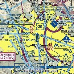
| Sectional chart |
|---|
|
CAUTION: Diagram may not be current
 Download PDF
of official airport diagram from the FAA
| Airport distance calculator |
|---|
|
|
| Sunrise and sunset |
|---|
|
Times for 27-Jun-2026
| | Local
(UTC-7) | | Zulu
(UTC) |
|---|
| Morning civil twilight | | 05:16 | | 12:16 |
| Sunrise | | 05:45 | | 12:45 |
| Sunset | | 20:09 | | 03:09 |
| Evening civil twilight | | 20:38 | | 03:38 |
|
| Current date and time |
|---|
| Zulu (UTC) | 27-Jun-2026 08:09:39 |
|---|
| Local (UTC-7) | 27-Jun-2026 01:09:39 |
|---|
|
| METAR |
|---|
| KVNY | 270751Z AUTO 12004KT 10SM CLR 16/13 A2994 RMK AO2 SLP131 T01560133 402780144 $
|
KWHP
4nm NE | 270155Z 12008G13KT 10SM SKC 23/12 A2994
|
KBUR
6nm E | 270753Z 20004KT 10SM BKN018 16/13 A2995 RMK AO2 SLP132 T01610133 402560156
|
KSMO
12nm S | 270751Z AUTO 00000KT 10SM OVC020 17/14 A2994 RMK AO2 SLP138 T01670139 402170161
|
KLAX
17nm S | 270753Z 00000KT 10SM BKN019 18/14 A2994 RMK AO2 SLP137 T01780139 402280167
|
KHHR
19nm SE | 270753Z AUTO 00000KT 10SM OVC023 18/14 A2994 RMK AO2 SLP138 T01830139 402280172
|
|
| TAF |
|---|
| KVNY | 270541Z 2706/2806 12006KT P6SM SKC FM271000 VRB03KT P6SM OVC008 FM271500 VRB03KT P6SM OVC012 FM271700 VRB03KT P6SM SKC FM272000 13010KT P6SM SKC FM280300 11006KT P6SM SKC
|
KBUR
6nm E | 270541Z 2706/2806 16006KT P6SM SKC FM270900 VRB03KT P6SM OVC008 FM271300 VRB03KT P6SM OVC012 FM271700 VRB03KT P6SM SKC FM272000 18010KT P6SM SKC FM280300 16006KT P6SM SKC
|
KSMO
12nm S | 270542Z 2706/2806 23006KT P6SM SCT015 FM270730 VRB03KT P6SM OVC015 FM271600 VRB03KT P6SM OVC025 FM271800 22006KT P6SM SCT025 FM272100 23012KT P6SM SKC FM280300 23005KT P6SM BKN020
|
KLAX
17nm S | 270541Z 2706/2812 26008KT P6SM SCT015 OVC020 FM270900 VRB03KT P6SM OVC015 FM271500 VRB03KT P6SM OVC025 FM271800 26010KT P6SM SCT025 FM272100 26015KT P6SM SKC FM280300 25008KT P6SM BKN025 FM280900 VRB03KT P6SM OVC015
|
|
| NOTAMs |
|---|
NOTAMs are issued by the DoD/FAA and will open in a separate window not controlled by AirNav.
|
|


