FAA INFORMATION EFFECTIVE 11 JUNE 2026
Location
| FAA Identifier: | VVS |
| Lat/Long: | 39-57-32.6000N 079-39-26.7000W
39-57.543333N 079-39.445000W
39.9590556,-79.6574167
(estimated) |
| Elevation: | 1264.4 ft. / 385.4 m (surveyed) |
| Variation: | 08W (1990) |
| From city: | 5 miles SW of CONNELLSVILLE, PA |
| Time zone: | UTC -4 (UTC -5 during Standard Time) |
| Zip code: | 15431 |
Airport Operations
| Airport use: | Open to the public |
| Activation date: | 04/1940 |
| Control tower: | no |
| ARTCC: | CLEVELAND CENTER |
| FSS: | ALTOONA FLIGHT SERVICE STATION |
| NOTAMs facility: | AOO (NOTAM-D service available) |
| Attendance: | 0800 - 1700 |
| Wind indicator: | lighted |
| Segmented circle: | yes |
| Lights: | ACTVT REIL RWY 05; PAPI RWY 05, 23 & 14. MIRL RWY 05/23 & 14/32 - CTAF. |
| Beacon: | white-green (lighted land airport)
Operates sunset to sunrise. |
| Landing fee: | yes, LDG FEE FOR ALL ACFT OVER 6000 LBS GWT; WAIVED FOR FUEL PURCHASE. |
Airport Communications
| CTAF/UNICOM: | 122.8 |
| WX AWOS-3P: | 133.325 (724-626-8745) |
| CLARKSBURG APPROACH: | 119.425 |
| CLARKSBURG DEPARTURE: | 119.425 |
| WX AWOS-3PT at FWQ (17 nm NW): | 118.475 (724-379-5815) |
- APCH/DEP SVC PRVDD BY CLEVELAND ARTCC (ZOB) ON FREQS 124.4/327.1 (ALTOONA RCAG) WHEN CLARKSBURG APCH CTL CLSD.
Nearby radio navigation aids
| VOR radial/distance | | VOR name | | Freq | | Var |
|---|
| MGWr026/25.9 | | MORGANTOWN VOR/DME | | 111.60 | | 05W |
| AGCr146/26.0 | | ALLEGHENY VOR/DME | | 110.00 | | 09W |
| NDB name | | Hdg/Dist | | Freq | | Var | | ID |
|---|
| CAMOR | | 049/6.1 | | 299 | | 08W | | VV | ...- ...- |
Airport Services
| Fuel available: | 100LL JET-A
100LL:SELF SVC 100LL AVBL 24 HRS; CREDIT CARD ONLY. |
| Parking: | hangars and tiedowns |
| Airframe service: | MAJOR |
| Powerplant service: | MAJOR |
Runway Information
Runway 5/23
| Dimensions: | 3833 x 100 ft. / 1168 x 30 m |
| Surface: | asphalt, in fair condition |
| Weight bearing capacity: | |
| Runway edge lights: | medium intensity |
| RUNWAY 5 | | RUNWAY 23 |
| Latitude: | 39-57.405628N | | 39-57.884745N |
| Longitude: | 079-39.739762W | | 079-39.205640W |
| Elevation: | 1219.6 ft. | | 1264.4 ft. |
| Traffic pattern: | left | | left |
| Runway heading: | 049 magnetic, 041 true | | 229 magnetic, 221 true |
| Markings: | nonprecision, in good condition | | basic, in good condition |
| Visual slope indicator: | 2-light PAPI on left (3.00 degrees glide path) | | 2-light PAPI on right (3.00 degrees glide path) |
| Runway end identifier lights: | yes | | |
| Touchdown point: | yes, no lights | | yes, no lights |
| Instrument approach: | LOCALIZER | | |
Runway 14/32
| Dimensions: | 2404 x 100 ft. / 733 x 30 m |
| Surface: | asphalt, in fair condition |
| Weight bearing capacity: | |
| Runway edge lights: | medium intensity
THLD & EDGE LGT OTS INDEF. |
| RUNWAY 14 | | RUNWAY 32 |
| Latitude: | 39-57.508242N | | 39-57.250210N |
| Longitude: | 079-39.597182W | | 079-39.207013W |
| Elevation: | 1227.5 ft. | | 1236.4 ft. |
| Traffic pattern: | left | | left |
| Runway heading: | 139 magnetic, 131 true | | 319 magnetic, 311 true |
| Markings: | basic, in good condition | | basic, in good condition |
| Visual slope indicator: | 2-light PAPI on left (3.00 degrees glide path)
PAPI OTS INDEF. | | |
| Touchdown point: | yes, no lights | | yes, no lights |
| Obstructions: | 48 ft. trees, 999 ft. from runway, 128 ft. right of centerline, 16:1 slope to clear | | 13 ft. trees, 339 ft. from runway, 110 ft. left of centerline, 10:1 slope to clear |
Airport Ownership and Management from official FAA records
| Ownership: | Publicly-owned |
| Owner: | FAYETTE COUNTY AIRPORT AUTHORITY
988 SKY DRIVE
LEMONT FURNACE, PA 15456
Phone 724-628-2276 |
| Manager: | JOHN NECKERAUER
988 SKY DRIVE
LEMONT FURNACE, PA 15456
Phone 724-628-2276
AFT HRS 412-916-6282. |
Additional Remarks
| - | RWY 23 HAS A 265 FT RELOCATED THR FOR TAXI ONLY. RWY 14 HAS A 315 FT RELOCATED THR FOR TAXI ONLY, RWY 32 HAS A 260 FT RELOCATED THR FOR TAXI ONLY. |
| - | DEER & BIRDS ON & INVOF ARPT. |
| - | TWY B CLSD TO ACFT WITH WINGSPAN MORE THAN 40 FT. |
| - | FOR CD CTC CLARKSBURG APCH AT 304-842-2011, WHEN APCH CLSD CTC CLEVELAND ARTCC AT 440-774-0226. |
| - | RWY 14/32: CLSD SS TO SR. |
| A58-05 | 16 FT TREES; 282 FT FM RWY END, 127 FT RIGHT. 8 FT TREES; 157 FT FM RWY END, 116 FT LEFT. 12 FT TREES; 271 FT FM RWY, 105 FT LEFT. |
Instrument Procedures
NOTE: All procedures below are presented as PDF files. If you need a reader for these files, you should download the free Adobe Reader.NOT FOR NAVIGATION. Please procure official charts for flight.
FAA instrument procedures published for use from 11 June 2026 at 0901Z to 09 July 2026 at 0900z.
IAPs - Instrument Approach Procedures |
|---|
| RNAV (GPS) RWY 05 | |
download (265KB) |
| LOC RWY 05 | |
download (228KB) |
| NOTE: Special Take-Off Minimums/Departure Procedures apply | |
download (208KB) |
Other nearby airports with instrument procedures:
KFWQ - Rostraver Airport (17 nm NW)
KLBE - Arnold Palmer Regional Airport (22 nm NE)
KWAY - Greene County Airport (22 nm W)
KMGW - Morgantown Municipal Airport/Walter L Bill Hart Field (22 nm SW)
G05 - Finleyville Airpark (24 nm NW)
|
|

Road maps at:
MapQuest
Bing
Google
| Aerial photo |
|---|
WARNING: Photo may not be current or correct
 Photo by John Diehl
Photo taken 23-Sep-2007
Photo by John Diehl
Photo taken 23-Sep-2007
Do you have a better or more recent aerial photo of Joseph A Hardy Connellsville Airport that you would like to share? If so, please send us your photo.
|
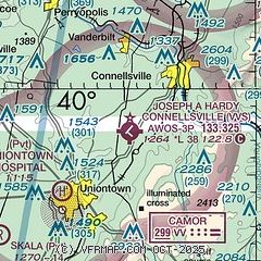
| Sectional chart |
|---|
|
| Airport distance calculator |
|---|
|
|
| Sunrise and sunset |
|---|
|
Times for 01-Jul-2026
| | Local
(UTC-4) | | Zulu
(UTC) |
|---|
| Morning civil twilight | | 05:22 | | 09:22 |
| Sunrise | | 05:55 | | 09:55 |
| Sunset | | 20:50 | | 00:50 |
| Evening civil twilight | | 21:23 | | 01:23 |
|
| Current date and time |
|---|
| Zulu (UTC) | 01-Jul-2026 15:05:17 |
|---|
| Local (UTC-4) | 01-Jul-2026 11:05:17 |
|---|
|
| METAR |
|---|
| KVVS | 011455Z AUTO 28007KT 10SM SCT016 SCT023 BKN039 29/24 A3012 RMK AO2 T02900243
|
KP53
17nm NW | 011456Z AUTO 00000KT 27/18 A2986 RMK AO1 SLP106 T02670178 53004 $
|
|
| TAF |
|---|
KLBE
22nm NE | 011122Z 0112/0212 24010KT P6SM SCT045
|
KMGW
22nm SW | 011122Z 0112/0212 25005KT P6SM FEW045
|
KAGC
26nm NW | 011122Z 0112/0212 26008KT P6SM SCT045
|
|
| NOTAMs |
|---|
NOTAMs are issued by the DoD/FAA and will open in a separate window not controlled by AirNav.
|
|

