FAA INFORMATION EFFECTIVE 18 APRIL 2024
Location
| FAA Identifier: | LPC |
| Lat/Long: | 34-39-56.2300N 120-28-03.0100W
34-39.937167N 120-28.050167W
34.6656194,-120.4675028
(estimated) |
| Elevation: | 88.1 ft. / 27 m (estimated) |
| Variation: | 15E (1980) |
| From city: | 2 miles N of LOMPOC, CA |
| Time zone: | UTC -7 (UTC -8 during Standard Time) |
| Zip code: | 93436 |
Airport Operations
| Airport use: | Open to the public |
| Activation date: | 03/1962 |
| Control tower: | no |
| ARTCC: | LOS ANGELES CENTER |
| FSS: | HAWTHORNE FLIGHT SERVICE STATION |
| NOTAMs facility: | LPC (NOTAM-D service available) |
| Attendance: | 0800-1700
ATNDD BY FBO, PHONE 805-717-3558. |
| Pattern altitude: | 901.1 ft. MSL |
| Wind indicator: | lighted |
| Segmented circle: | yes |
| Lights: | ACTVT REIL RWY 25; MIRL RWY 07/25 - CTAF. PAPI RWY 25 ON CONSLY. |
| Beacon: | white-green (lighted land airport)
Operates sunset to sunrise. |
Airport Communications
| CTAF/UNICOM: | 122.7 |
| WX AWOS-3PT: | 133.875 (805-735-3075) |
| SANTA BARBARA APPROACH: | 124.15 |
| SANTA BARBARA DEPARTURE: | 124.15 |
| WX ASOS at SMX (14 nm N): | 121.15 (805-928-0384) |
| WX AWOS-3PT at IZA (20 nm E): | 118.075 (805-686-5325) |
- APCH/DEP CTL SVC PRVDD BY LOS ANGELES ARTCC (ZLA) ON FREQS 119.05/269.5 (SAN LUIS OBISPO RCAG) WHEN SANTA BARBARA APCH CTL (SBA) CLSD.
Nearby radio navigation aids
| VOR radial/distance | | VOR name | | Freq | | Var |
|---|
| GLJr155/(17.4) | | GUADALUPE VOR | | 113.05 | | 16E |
| GVOr277/20.3 | | GAVIOTA VORTAC | | 113.80 | | 16E |
| RZSr271/35.7 | | SAN MARCUS VORTAC | | 114.90 | | 14E |
| MQOr142/38.0 | | MORRO BAY VORTAC | | 112.40 | | 16E |
| FLWr213/39.2 | | FELLOWS VOR/DME | | 117.50 | | 16E |
Airport Services
| Fuel available: | 100LL JET-A
100LL:FUEL AVBL 24 HRS; SELF-SERVICE CREDIT CARD ONLY. |
| Parking: | tiedowns |
| Airframe service: | MAJOR |
| Powerplant service: | MAJOR |
| Bottled oxygen: | HIGH |
| Bulk oxygen: | HIGH |
Runway Information
Runway 7/25
| Dimensions: | 4600 x 100 ft. / 1402 x 30 m |
| Surface: | asphalt, in excellent condition |
| Weight bearing capacity: | |
| Runway edge lights: | medium intensity |
| RUNWAY 7 | | RUNWAY 25 |
| Latitude: | 34-39.943500N | | 34-39.930833N |
| Longitude: | 120-28.509000W | | 120-27.591333W |
| Elevation: | 79.0 ft. | | 88.1 ft. |
| Traffic pattern: | left | | right |
| Runway heading: | 076 magnetic, 091 true | | 256 magnetic, 271 true |
| Displaced threshold: | no | | 118 ft. |
| Markings: | nonprecision, in good condition | | nonprecision, in good condition |
| Visual slope indicator: | | | 4-light PAPI on left (3.25 degrees glide path) |
| Runway end identifier lights: | no | | yes |
| Touchdown point: | yes, no lights | | yes, no lights |
| Obstructions: | 25 ft. brush, 720 ft. from runway, 20:1 slope to clear | | 25 ft. pline, marked, 1050 ft. from runway, 34:1 slope to clear |
Airport Ownership and Management from official FAA records
| Ownership: | Publicly-owned |
| Owner: | CITY OF LOMPOC
100 CIVIC CENTER PLAZA
LOMPOC, CA 93436-8001
Phone 805-875-8268 |
| Manager: | RICHARD FERNBAUGH
CITY OF LOMPOC, 100 CIVIC CENTER PLAZA
LOMPOC, CA 93436-8001
Phone 805-875-8268 |
Airport Operational Statistics
| Aircraft based on the field: | | 42 | | Single engine airplanes: | | 41 | | Multi engine airplanes: | | 1 |
| |  | |
| Aircraft operations: avg 82/day * | | 50% | transient general aviation | | 50% | local general aviation | | * for 12-month period ending 16 October 2023 | |
Additional Remarks
| - | DEER ON & INVOF ARPT. |
| - | ULTRALIGHT, AND SKY DIVING ACTIVITY INVOF OF ARPT DALGT HRS FRI-SUN. |
| - | FOR CD CTC LOS ANGELES ARTCC AT 661-575-2079. |
| - | TWY LGTS OTS UFN. |
Instrument Procedures
NOTE: All procedures below are presented as PDF files. If you need a reader for these files, you should download the free Adobe Reader.NOT FOR NAVIGATION. Please procure official charts for flight.
FAA instrument procedures published for use from 18 April 2024 at 0901Z to 16 May 2024 at 0900Z.
IAPs - Instrument Approach Procedures |
|---|
| RNAV (GPS) RWY 25 | |
download (319KB) |
| VOR/DME-A **CHANGED** | |
download (320KB) |
| NOTE: Special Alternate Minimums apply | |
download (125KB) |
| NOTE: Special Take-Off Minimums/Departure Procedures apply | |
download (353KB) |
Other nearby airports with instrument procedures:
KVBG - Vandenberg Space Force Base (7 nm NW)
KSMX - Santa Maria Public Airport/Capt G Allan Hancock Field (14 nm N)
KIZA - Santa Ynez Airport/Kunkle Field (20 nm E)
KSBA - Santa Barbara Municipal Airport (34 nm SE)
KSBP - San Luis Obispo County Regional Airport (35 nm N)
|
|

Road maps at:
MapQuest
Bing
Google
| Aerial photo |
|---|
WARNING: Photo may not be current or correct

Do you have a better or more recent aerial photo of Lompoc Airport that you would like to share? If so, please send us your photo.
|
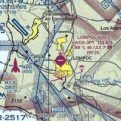
| Sectional chart |
|---|
|
| Airport distance calculator |
|---|
|
|
| Sunrise and sunset |
|---|
|
Times for 19-Apr-2024
| | Local
(UTC-7) | | Zulu
(UTC) |
|---|
| Morning civil twilight | | 05:59 | | 12:59 |
| Sunrise | | 06:25 | | 13:25 |
| Sunset | | 19:37 | | 02:37 |
| Evening civil twilight | | 20:03 | | 03:03 |
|
| Current date and time |
|---|
| Zulu (UTC) | 20-Apr-2024 02:22:51 |
|---|
| Local (UTC-7) | 19-Apr-2024 19:22:51 |
|---|
|
| METAR |
|---|
| KLPC | 200156Z AUTO 29010KT 10SM OVC016 13/11 A2998 RMK AO2 SLP153 T01280106
|
KVBG
5nm W | 200155Z AUTO 34010KT 9SM OVC011 10/08 A2999 RMK AO2 SLP159 T01040078 TSNO $
|
KSMX
14nm N | 200151Z 30011KT 8SM BKN019 13/10 A2998 RMK AO2 SLP154 T01280100 $
|
|
| TAF |
|---|
KVBG
5nm W | 192200Z 1922/2104 33010G15KT 9999 BKN014 BKN017 QNH2993INS BECMG 2000/2001 32010G15KT 9000 BR BKN008 QNH2995INS BECMG 2002/2003 34009KT 3200 BR OVC004 QNH2997INS BECMG 2004/2005 35006KT 0400 FG VV001 QNH2999INS BECMG 2016/2017 33006KT 3200 BR OVC002 QNH2999INS BECMG 2017/2018 32009KT 9999 NSW OVC005 QNH2996INS BECMG 2019/2020 32012G18KT 9999 SCT007 QNH2994INS BECMG 2101/2102 33010G15KT 9999 FEW010 QNH2995INS TX17/2022Z TN10/2013Z LAST NO AMDS AFT 1922 NEXT 2214
|
KSMX
14nm N | 192040Z 1921/2018 30012KT P6SM SCT020 FM200100 31006KT 5SM BR OVC008 FM200500 VRB03KT 2SM BR OVC004 FM201400 VRB03KT 3SM BR OVC006 FM201700 VRB03KT P6SM OVC012
|
|
| NOTAMs |
|---|
NOTAMs are issued by the DoD/FAA and will open in a separate window not controlled by AirNav.
|
|
