FAA INFORMATION EFFECTIVE 27 NOVEMBER 2025
Location
| FAA Identifier: | LVK |
| Lat/Long: | 37-41-36.2000N 121-49-13.3000W
37-41.603333N 121-49.221667W
37.6933889,-121.8203611
(estimated) |
| Elevation: | 399.9 ft. / 121.9 m (surveyed) |
| Variation: | 16E (1980) |
| From city: | 3 miles W of LIVERMORE, CA |
| Time zone: | UTC -8 (UTC -7 during Daylight Saving Time) |
| Zip code: | 94550 |
Airport Operations
| Airport use: | Open to the public |
| Activation date: | 12/1965 |
| Control tower: | yes |
| ARTCC: | OAKLAND CENTER |
| FSS: | OAKLAND FLIGHT SERVICE STATION |
| NOTAMs facility: | LVK (NOTAM-D service available) |
| Attendance: | MON-FRI 0730-1700, ALL SAT-SUN 0700-1100 |
| Wind indicator: | lighted |
| Segmented circle: | yes |
| Lights: | ATC CNTL. WHEN ATCT CLSD, ACTVT MALSR RWY 25R; TWY LGTS - 118.1. HIRL RWY 07L/25R OPER LOW INTST; TO INCREASE INTST ACTVT 118.1. MIRL RWY 07R/25L OPER LOW INTST; NOT AVBL WHEN ATCT CLSD. PAPI RWY 07L AND 25R OPR CONSLY. |
| Beacon: | white-green (lighted land airport)
Operates sunset to sunrise. |
Airport Communications
| CTAF: | 118.1 |
| UNICOM: | 122.95 |
| ATIS: | 119.65 |
| WX ASOS: | PHONE 925-606-5412 |
| LIVERMORE GROUND: | 121.6 [0700-2100] |
| LIVERMORE TOWER: | 118.1 239.25 [0700-2100] |
| NORCAL APPROACH: | 123.85 ;RWY 07L/25R, 07R/25L |
| NORCAL DEPARTURE: | 123.85 ;RWY 07L, 07R 125.35 ;RWY 25L, 25R |
| WX AWOS-3 at C83 (12 nm NE): | 123.775 (925-634-0906) |
| WX ASOS at HWD (14 nm W): | PHONE 510-786-3052 |
| WX AWOS-3 at TCY (18 nm E): | 118.375 (209-831-4335) |
| WX ASOS at OAK (19 nm W): | PHONE 510-214-1776 |
| WX AWOS-3PT at NUQ (20 nm SW): | 124.175 (650-386-0655) |
- FREQ 121.5 NOT AVAILABLE.
Nearby radio navigation aids
| VOR radial/distance | | VOR name | | Freq | | Var |
|---|
| OAKr079/19.2 | | OAKLAND VOR/DME | | 116.80 | | 17E |
| SJCr001/20.0 | | SAN JOSE VOR/DME | | 114.10 | | 16E |
| CCRr136/23.6 | | CONCORD VOR/DME | | 117.00 | | 17E |
| SFOr063/26.7 | | SAN FRANCISCO VOR/DME | | 115.80 | | 17E |
| OSIr034/28.4 | | WOODSIDE VOR/DME | | 113.90 | | 17E |
| SAUr089/34.7 | | SAUSALITO VOR/DME | | 116.20 | | 17E |
| SGDr121/39.2 | | SCAGGS ISLAND VORTAC | | 112.10 | | 17E |
Airport Services
| Fuel available: | 100LL JET-A |
| Parking: | tiedowns |
| Airframe service: | MAJOR |
| Powerplant service: | MAJOR |
| Bottled oxygen: | HIGH |
| Bulk oxygen: | HIGH |
Runway Information
Runway 7L/25R
| Dimensions: | 5253 x 100 ft. / 1601 x 30 m |
| Surface: | asphalt/grooved, in excellent condition |
| Weight bearing capacity: | | Single wheel: | 45.0 | | Double wheel: | 90.0 |
|
| Runway edge lights: | high intensity
RWY EDGE LGT ON LOW AND MED INTST LEVEL ON DOWNWIND LEG OF TFC PAT DFCLT TO SEE. |
| RUNWAY 7L | | RUNWAY 25R |
| Latitude: | 37-41.636222N | | 37-41.627625N |
| Longitude: | 121-49.764095W | | 121-48.675008W |
| Elevation: | 372.9 ft. | | 399.9 ft. |
| Traffic pattern: | left | | right |
| Runway heading: | 074 magnetic, 090 true | | 254 magnetic, 270 true |
| Markings: | precision, in good condition | | precision, in good condition |
| Visual slope indicator: | 4-light PAPI on right (4.00 degrees glide path) | | 4-light PAPI on left (3.00 degrees glide path) |
| Approach lights: | | | MALSR: 1,400 foot medium intensity approach lighting system with runway alignment indicator lights |
| Touchdown point: | yes, no lights | | yes, no lights |
| Instrument approach: | | | ILS/DME |
| Obstructions: | 75 ft. tree, 2016 ft. from runway, 350 ft. left of centerline, 24:1 slope to clear
+6 FT FENCE 180 FT FM RY END 400 FT LEFT OF EXTDD CNTRLN. | | 24 ft. bldg, 638 ft. from runway, 560 ft. right of centerline, 18:1 slope to clear |
Runway 7R/25L
| Dimensions: | 2699 x 75 ft. / 823 x 23 m |
| Surface: | asphalt, in excellent condition |
| Weight bearing capacity: | |
| Runway edge lights: | medium intensity |
| RUNWAY 7R | | RUNWAY 25L |
| Latitude: | 37-41.551892N | | 37-41.547342N |
| Longitude: | 121-49.505328W | | 121-48.945675W |
| Elevation: | 378.8 ft. | | 394.6 ft. |
| Traffic pattern: | right | | left |
| Runway heading: | 074 magnetic, 090 true | | 254 magnetic, 270 true |
| Markings: | basic, in good condition | | basic, in good condition |
| Touchdown point: | yes, no lights | | yes, no lights |
Helipad H1
| Dimensions: | 24 x 22 ft. / 7 x 7 m |
| Surface: | asphalt, in good condition |
| Latitude: | 37-41.435500N | | |
| Longitude: | 121-49.402000W | | |
| Elevation: | 382.0 ft. | | |
| Traffic pattern: | left | | left |
Airport Ownership and Management from official FAA records
| Ownership: | Publicly-owned |
| Owner: | CITY OF LIVERMORE
1052 SOUTH LIVERMORE AVE
LIVERMORE, CA 94550
Phone 925-960-4200 |
| Manager: | BENEDICT STUTH
680 TERMINAL CIRCLE
LIVERMORE, CA 94551
Phone 925-960-8230 |
Additional Remarks
| - | BE ALERT TO CONSIDERABLE BIRD ACTIVITY ON & IN VICINITY OF ARPT. |
| - | DO NOT MISTAKE PARALLEL TAXIWAY N OF RWY 25R/7L AS RWY. NOISE SENSITIVE AREAS 3/4 MILE EAST & 2 MILES W OF ARPT. |
| - | EFFECTIVE RY GRADIENT RY 07L 0.52% UP; RY 07R 0.59% UP. |
| - | FOR CD WHEN ATCT IS CLSD CTC NORCAL APCH AT 916-361-0516. |
| - | PLS OBS "VOLUNTARY RESTRAINT FROM NIGHT FLYING 2200L-0600L POLICY." |
Instrument Procedures
NOTE: All procedures below are presented as PDF files. If you need a reader for these files, you should download the free Adobe Reader.NOT FOR NAVIGATION. Please procure official charts for flight.
FAA instrument procedures published for use from 27 November 2025 at 0901Z to 25 December 2025 at 0900Z.
IAPs - Instrument Approach Procedures |
|---|
| ILS RWY 25R | |
download (208KB) |
| RNAV (GPS) RWY 25R | |
download (257KB) |
| LOC RWY 25R | |
download (250KB) |
| NOTE: Special Alternate Minimums apply | |
download (136KB) |
|
|---|
| LIVERMORE THREE (OBSTACLE) | |
2 pages:
[1] [2] (599KB) |
| NOTE: Special Take-Off Minimums/Departure Procedures apply | |
download (227KB) |
Other nearby airports with instrument procedures:
C83 - Byron Airport (12 nm NE)
KHWD - Hayward Executive Airport (14 nm W)
KTCY - Tracy Municipal Airport (18 nm E)
KOAK - Oakland San Francisco Bay Airport (19 nm W)
KPAO - Palo Alto Airport (20 nm SW)
KNUQ - Moffett Federal Airfield (20 nm SW)
|
|

Road maps at:
MapQuest
Bing
Google
| Aerial photo |
|---|
WARNING: Photo may not be current or correct
 Photo by Sai Dwibhashyam
Photo taken 29-Jul-2020
looking east.
Photo by Sai Dwibhashyam
Photo taken 29-Jul-2020
looking east.
Do you have a better or more recent aerial photo of Livermore Municipal Airport that you would like to share? If so, please send us your photo.
|
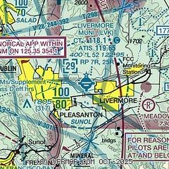
| Sectional chart |
|---|
|
 Download PDF
of official airport diagram from the FAA
| Airport distance calculator |
|---|
|
|
| Sunrise and sunset |
|---|
|
Times for 11-Dec-2025
| | Local
(UTC-8) | | Zulu
(UTC) |
|---|
| Morning civil twilight | | 06:44 | | 14:44 |
| Sunrise | | 07:13 | | 15:13 |
| Sunset | | 16:48 | | 00:48 |
| Evening civil twilight | | 17:17 | | 01:17 |
|
| Current date and time |
|---|
| Zulu (UTC) | 11-Dec-2025 15:46:23 |
|---|
| Local (UTC-8) | 11-Dec-2025 07:46:23 |
|---|
|
| METAR |
|---|
| KLVK | 111527Z 07008KT 5SM BR OVC003 05/04 A3017 RMK AO2 T00500044
|
KC83
12nm NE | 111535Z AUTO 07004KT 2SM BR OVC003 06/06 A3021 RMK AO2
|
KHWD
14nm W | 111454Z AUTO 05004KT 9SM BKN007 07/05 A3016 RMK AO2 SLP221 T00670050 53005
|
KTCY
18nm E | 111535Z AUTO 16006KT 4SM BR OVC004 05/05 A3020 RMK A01
|
KOAK
19nm W | 111453Z 00000KT 10SM FEW007 07/06 A3016 RMK AO2 SLP213 T00670056 53005
|
KNUQ
19nm SW | 111535Z AUTO 00000KT 5SM BR SCT003 05/05 A3016 RMK AO2
|
KPAO
20nm SW | 111447Z 00000KT 10SM BKN030 04/04 A3016
|
|
| TAF |
|---|
| KLVK | 111120Z 1112/1212 04005KT 1/2SM FG OVC002 FM111800 07008KT 5SM BR FEW005 FM120600 04004KT 3SM BR BKN005
|
KOAK
19nm W | 111120Z 1112/1218 02005KT 6SM BR FEW005 FM111900 31006KT P6SM FEW007 FM120300 34004KT P6SM SKC FM120700 VRB03KT P6SM FEW005 FM121000 VRB03KT 5SM BR FEW005
|
|
| NOTAMs |
|---|
NOTAMs are issued by the DoD/FAA and will open in a separate window not controlled by AirNav.
|
|


