FAA INFORMATION EFFECTIVE 12 JUNE 2025
Location
| FAA Identifier: | M13 |
| Lat/Long: | 30-47-11.6750N 089-30-16.3350W
30-47.194583N 089-30.272250W
30.7865764,-89.5045375
(estimated) |
| Elevation: | 318.9 ft. / 97.2 m (surveyed) |
| Variation: | 02W (2020) |
| From city: | 3 miles SE of POPLARVILLE, MS |
| Time zone: | UTC -5 (UTC -6 during Standard Time) |
| Zip code: | 39470 |
Airport Operations
| Airport use: | Open to the public |
| Activation date: | 03/1976 |
| Control tower: | no |
| ARTCC: | HOUSTON CENTER |
| FSS: | GREENWOOD FLIGHT SERVICE STATION |
| NOTAMs facility: | GWO (NOTAM-D service available) |
| Attendance: | UNATNDD |
| Wind indicator: | lighted |
| Segmented circle: | yes |
| Lights: | MIRL RWY 16/34 OPER DUSK - 2100. AFT 2100 ACTVT - CTAF. PAPI RWY 16 & 34 OPR CONSLY. |
| Beacon: | white-green (lighted land airport)
Operates sunset to sunrise. |
Airport Communications
| CTAF: | 122.9 |
| GULFPORT APPROACH: | 124.6 |
| GULFPORT DEPARTURE: | 124.6 |
| WX AWOS-3PT at BXA (19 nm W): | 118.025 (985-732-6224) |
| WX AWOS-3PT at MJD (19 nm SW): | 119.075 (601-798-4136) |
- APCH/DEP SVC PRVDD BY HOUSTON ARTCC (ZHU) ON 126.8/327.8 (HATTIESBURG RCAG) WHEN GPT APCH CLSD.
Nearby radio navigation aids
| VOR radial/distance | | VOR name | | Freq | | Var |
|---|
| PCUr036/17.9 | | PICAYUNE VOR/DME | | 113.95 | | 05E |
| GPTr314/31.7 | | GULFPORT VORTAC | | 109.00 | | 02E |
| LBYr188/38.9 | | EATON VORTAC | | 110.60 | | 05E |
| NDB name | | Hdg/Dist | | Freq | | Var | | ID |
|---|
| BOGALUSA | | 107/19.3 | | 353 | | 00W | | GVB | --. ...- -... |
Airport Services
| Fuel available: | 100LL
100LL:FUEL 24 HR SELF SVC WITH CREDIT CARD. |
| Parking: | tiedowns |
| Airframe service: | MAJOR |
| Powerplant service: | MAJOR |
| Bottled oxygen: | NONE |
| Bulk oxygen: | NONE |
Runway Information
Runway 16/34
| Dimensions: | 4000 x 100 ft. / 1219 x 30 m |
| Surface: | asphalt, in fair condition |
| Weight bearing capacity: | |
| Runway edge lights: | medium intensity |
| RUNWAY 16 | | RUNWAY 34 |
| Latitude: | 30-47.510000N | | 30-46.879167N |
| Longitude: | 089-30.384000W | | 089-30.160500W |
| Elevation: | 302.6 ft. | | 318.9 ft. |
| Traffic pattern: | left | | left |
| Runway heading: | 165 magnetic, 163 true | | 345 magnetic, 343 true |
| Markings: | nonprecision, in fair condition | | nonprecision, in fair condition |
| Visual slope indicator: | 2-light PAPI on left (3.00 degrees glide path) | | 2-light PAPI on left (3.00 degrees glide path) |
| Touchdown point: | yes, no lights | | yes, no lights |
| Obstructions: | 55 ft. trees, 1650 ft. from runway, 26:1 slope to clear | | 29 ft. trees, 800 ft. from runway, 20:1 slope to clear |
Airport Ownership and Management from official FAA records
| Ownership: | Publicly-owned |
| Owner: | CITY OF POPLARVILLE & PEARL RIVER
CITY HALL, 101 N MAIN ST
POPLARVILLE, MS 39470
Phone 601-795-8161 |
| Manager: | BRADLEY HOLLIDAY
PO BOX 901
POPLARVILLE, MS 39470
Phone 601-550-3059 |
Additional Remarks
| A30A-34 | TRRN DROPS OFF ABRUPTLY 200 FT FM THR. |
| A30A-16 | 335 FT AGL ANT TWR ON L DOWNWIND PAT. |
| - | ULTRALIGHT ACT ON & INVOF ARPT. |
| - | FOR CD CTC GULFPORT APCH AT 228-265-6151, WHEN APCH CLSD CTC HOUSTON ARTCC AT 281-230-5622. |
Instrument Procedures
NOTE: All procedures below are presented as PDF files. If you need a reader for these files, you should download the free Adobe Reader.NOT FOR NAVIGATION. Please procure official charts for flight.
FAA instrument procedures published for use from 12 June 2025 at 0901Z to 10 July 2025 at 0900z.
IAPs - Instrument Approach Procedures |
|---|
| RNAV (GPS)-A **CHANGED** | |
download (180KB) |
| RNAV (GPS)-B **CHANGED** | |
download (189KB) |
| NOTE: Special Take-Off Minimums/Departure Procedures apply | |
download (300KB) |
Other nearby airports with instrument procedures:
M24 - Dean Griffin Memorial Airport (18 nm E)
KBXA - George R Carr Memorial Air Field (19 nm W)
KMJD - Picayune Municipal Airport (19 nm SW)
KHSA - Stennis International Airport (25 nm S)
KASD - Slidell Airport (31 nm SW)
|
|

Road maps at:
MapQuest
Bing
Google
| Aerial photo |
|---|
WARNING: Photo may not be current or correct
 Photo by Michael Lott
Photo taken 25-Oct-2008
looking south.
Photo by Michael Lott
Photo taken 25-Oct-2008
looking south.
Do you have a better or more recent aerial photo of Poplarville/Pearl River County Airport that you would like to share? If so, please send us your photo.
|
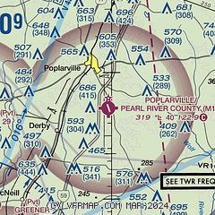
| Sectional chart |
|---|
|
| Airport distance calculator |
|---|
|
|
| Sunrise and sunset |
|---|
|
Times for 19-Jun-2025
| | Local
(UTC-5) | | Zulu
(UTC) |
|---|
| Morning civil twilight | | 05:28 | | 10:28 |
| Sunrise | | 05:56 | | 10:56 |
| Sunset | | 20:03 | | 01:03 |
| Evening civil twilight | | 20:30 | | 01:30 |
|
| Current date and time |
|---|
| Zulu (UTC) | 19-Jun-2025 17:39:21 |
|---|
| Local (UTC-5) | 19-Jun-2025 12:39:21 |
|---|
|
| METAR |
|---|
KBXA
19nm W | 191715Z AUTO 27006KT 10SM SCT039 SCT050 33/24 A3014 RMK AO2 T03330237
|
KHSA
25nm S | 191650Z 27005KT 10SM SCT030 33/23 A3013
|
KGPT
31nm SE | 191653Z VRB05KT 10SM BKN037 BKN046 32/23 A3012 RMK AO2 SLP199 T03220228
|
KHBG
32nm NE | 191653Z AUTO 27006KT 10SM SCT035 SCT049 32/23 A3014 RMK AO2 SLP203 T03220233
|
K0R0
34nm NW | 191715Z AUTO VRB04KT CLR 34/26 A3016 RMK AO2
|
KASD
35nm SW | 191653Z AUTO VRB06KT 10SM CLR 32/22 A3013 RMK AO2 SLP202 T03170222
|
|
| TAF |
|---|
KGPT
31nm SE | 191134Z 1912/2012 00000KT P6SM FEW060 FM191800 23007KT P6SM FEW035 FEW110 PROB30 1921/1924 4SM TSRA BR BKN035CB
|
KHBG
32nm NE | 191136Z 1912/2012 21004KT P6SM SCT002 FM191400 24005KT P6SM SCT035 SCT050
|
|
| NOTAMs |
|---|
NOTAMs are issued by the DoD/FAA and will open in a separate window not controlled by AirNav.
|
|


