FAA INFORMATION EFFECTIVE 14 MAY 2026
Location
| FAA Identifier: | M24 |
| Lat/Long: | 30-50-34.8000N 089-09-41.4000W
30-50.580000N 089-09.690000W
30.8430000,-89.1615000
(estimated) |
| Elevation: | 273 ft. / 83.2 m (surveyed) |
| Variation: | 02W (2025) |
| From city: | 1 mile W of WIGGINS, MS |
| Time zone: | UTC -5 (UTC -6 during Standard Time) |
| Zip code: | 39577 |
Airport Operations
| Airport use: | Open to the public |
| Control tower: | no |
| ARTCC: | HOUSTON CENTER |
| FSS: | GREENWOOD FLIGHT SERVICE STATION |
| NOTAMs facility: | GWO (NOTAM-D service available) |
| Attendance: | 0800-1700 |
| Wind indicator: | lighted |
| Segmented circle: | no |
| Lights: | ACTVT MIRL RWY 17/35 - CTAF. PAPI RWY 17 & 35 OPR CONSLY. |
| Beacon: | white-green (lighted land airport)
Operates sunset to sunrise. |
Airport Communications
| CTAF/UNICOM: | 122.8 |
| GULFPORT APPROACH: | 127.5 |
| GULFPORT DEPARTURE: | 127.5 |
- APCH/DEP SVC PRVDD BY HOUSTON ARTCC (ZHU) ON FREQS 126.8/327.8 (HATTIESBURG RCAG) WHEN GULFPORT APCH CTL (GPT) CLSD.
Nearby radio navigation aids
| VOR radial/distance | | VOR name | | Freq | | Var |
|---|
| GPTr349/26.5 | | GULFPORT VORTAC | | 109.00 | | 02E |
| PCUr055/33.9 | | PICAYUNE VOR/DME | | 113.95 | | 05E |
| LBYr160/35.7 | | EATON VORTAC | | 110.60 | | 05E |
| NDB name | | Hdg/Dist | | Freq | | Var | | ID |
|---|
| BOGALUSA | | 094/36.2 | | 353 | | 00W | | GVB | --. ...- -... |
Airport Services
| Fuel available: | 100LL
100LL:FUEL AVBL 24 HRS WITH CREDIT CARD. |
| Parking: | tiedowns |
| Airframe service: | NONE |
| Bottled oxygen: | NONE |
| Bulk oxygen: | NONE |
Runway Information
Runway 17/35
| Dimensions: | 3500 x 75 ft. / 1067 x 23 m |
| Surface: | asphalt, in excellent condition |
| Weight bearing capacity: | | PCN 10 /F/A/Y/T | | Single wheel: | 20.0 |
|
| Runway edge lights: | medium intensity |
| RUNWAY 17 | | RUNWAY 35 |
| Latitude: | 30-50.866725N | | 30-50.293587N |
| Longitude: | 089-09.729418W | | 089-09.649293W |
| Elevation: | 273.0 ft. | | 245.3 ft. |
| Traffic pattern: | left | | left |
| Runway heading: | 175 magnetic, 173 true | | 355 magnetic, 353 true |
| Displaced threshold: | 500 ft. | | no |
| Markings: | basic, in good condition | | basic, in good condition |
| Visual slope indicator: | 2-light PAPI on left (3.00 degrees glide path) | | 2-light PAPI on left (3.00 degrees glide path) |
| Touchdown point: | yes, no lights | | yes, no lights |
| Obstructions: | 41 ft. tree, 1200 ft. from runway, 150 ft. left of centerline, 24:1 slope to clear
APCH SLP 36:1 TO DTHR. | | 62 ft. trees, 1440 ft. from runway, 300 ft. right of centerline, 20:1 slope to clear |
Airport Ownership and Management from official FAA records
| Ownership: | Publicly-owned |
| Owner: | CITY OF WIGGINS-STONE CO
117 FIRST ST
WIGGINS, MS 39577
Phone 601-928-7221 |
| Manager: | DURON HATTEN
PO BOX 219
WIGGINS, MS 39577
Phone 601-928-7221 |
Additional Remarks
| - | FOR CD CTC GULFPORT APCH AT 228-265-6151, WHEN APCH CLSD CTC HOUSTON ARTCC AT 281-230-5622. |
Instrument Procedures
NOTE: All procedures below are presented as PDF files. If you need a reader for these files, you should download the free Adobe Reader.NOT FOR NAVIGATION. Please procure official charts for flight.
FAA instrument procedures published for use from 14 May 2026 at 0901Z to 11 June 2026 at 0900Z.
IAPs - Instrument Approach Procedures |
|---|
| RNAV (GPS) RWY 17 | |
download (166KB) |
| RNAV (GPS) RWY 35 | |
download (173KB) |
| NOTE: Special Take-Off Minimums/Departure Procedures apply | |
download (306KB) |
Other nearby airports with instrument procedures:
M13 - Poplarville/Pearl River County Airport (18 nm W)
KHBG - Hattiesburg Bobby L Chain Municipal Airport (26 nm N)
KGPT - Gulfport-Biloxi International Airport (27 nm S)
KBIX - Keesler Air Force Base (29 nm SE)
KHSA - Stennis International Airport (32 nm SW)
|
|

Road maps at:
MapQuest
Bing
Google
| Aerial photo |
|---|
WARNING: Photo may not be current or correct
 Photo by Iden Mersereau
Photo taken 29-Dec-2020
looking south.
Photo by Iden Mersereau
Photo taken 29-Dec-2020
looking south.
Do you have a better or more recent aerial photo of Dean Griffin Memorial Airport that you would like to share? If so, please send us your photo.
|
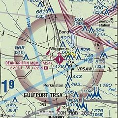
| Sectional chart |
|---|
|
| Airport distance calculator |
|---|
|
|
| Sunrise and sunset |
|---|
|
Times for 31-May-2026
| | Local
(UTC-5) | | Zulu
(UTC) |
|---|
| Morning civil twilight | | 05:28 | | 10:28 |
| Sunrise | | 05:55 | | 10:55 |
| Sunset | | 19:53 | | 00:53 |
| Evening civil twilight | | 20:21 | | 01:21 |
|
| Current date and time |
|---|
| Zulu (UTC) | 31-May-2026 18:13:31 |
|---|
| Local (UTC-5) | 31-May-2026 13:13:31 |
|---|
|
| METAR |
|---|
KHBG
26nm N | 311753Z AUTO 00000KT 10SM FEW043 SCT055 33/23 A2997 RMK AO2 SLP144 T03280228 10328 20233 58005 PWINO $
|
KGPT
26nm S | 311753Z 20008KT 10SM CLR 31/23 A2996 RMK AO2 SLP145 T03110233 10317 20256 58003
|
KBIX
29nm SE | 311755Z AUTO 22012KT 10SM FEW190 31/22 A2994 RMK AO2 SLP141 T03130223 10313 20262 58002
|
KHSA
32nm SW | 311747Z 23006KT 10SM SCT037 32/23 A2996
|
KBXA
36nm W | 311755Z AUTO 18006KT 10SM CLR 33/24 A2997 RMK AO2 T03310240 10331 20249
|
KPIB
38nm N | 311756Z AUTO 00000KT 10SM FEW044 SCT060 33/22 A2998 RMK AO2 SLP150 T03330222 10333 20239 58004 $
|
KLUL
38nm N | 311755Z AUTO 33007KT 10SM SCT043 SCT060 32/22 A2997 RMK A02 T03230224 10332 20240
|
KPQL
40nm SE | 311753Z 20007KT 170V240 10SM CLR 31/24 A2996 RMK AO2 SLP148 T03060244 10311 20250 58004
|
K0R0
43nm NW | 311755Z AUTO 00000KT 10SM FEW038 32/26 A2999 RMK AO2
|
KASD
47nm SW | 311753Z AUTO VRB04KT 10SM CLR 31/23 A2997 RMK AO2 SLP147 T03110228 10311 20233 58002 $
|
|
| TAF |
|---|
KHBG
26nm N | 311727Z 3118/0118 28004KT P6SM SCT250 PROB30 3122/0101 4SM -TSRA BKN050CB FM011100 24001KT 5SM BR SCT250 FM011200 25001KT 4SM BR BKN003 FM011300 25001KT P6SM BKN250
|
KGPT
26nm S | 311720Z 3118/0118 21007KT P6SM FEW030 SCT110
|
|
| NOTAMs |
|---|
NOTAMs are issued by the DoD/FAA and will open in a separate window not controlled by AirNav.
|
|

