FAA INFORMATION EFFECTIVE 09 JULY 2026
Location
| FAA Identifier: | M55 |
| Lat/Long: | 33-50-48.1880N 088-06-55.7130W
33-50.803133N 088-06.928550W
33.8467189,-88.1154758
(estimated) |
| Elevation: | 463 ft. / 141.1 m (surveyed) |
| Variation: | 02W (2010) |
| From city: | 6 miles N of VERNON, AL |
| Time zone: | UTC -5 (UTC -6 during Standard Time) |
| Zip code: | 35586 |
Airport Operations
| Airport use: | Open to the public |
| Activation date: | 08/1965 |
| Control tower: | no |
| ARTCC: | MEMPHIS CENTER |
| FSS: | ANNISTON FLIGHT SERVICE STATION |
| NOTAMs facility: | ANB (NOTAM-D service available) |
| Attendance: | UNATNDD |
| Wind indicator: | yes |
| Segmented circle: | no |
| Lights: | ARPT LGTS INOP. |
Airport Communications
| CTAF: | 122.9 |
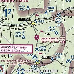
| COLUMBUS APPROACH: | 126.075 |
| COLUMBUS DEPARTURE: | 126.075 |
| WX AWOS-3P at M40 (19 nm W): | 118.475 (662-369-3498) |
- APCH/DEP SVC PRVDD BY MEMPHIS ARTCC (COLUMBUS RCAG) ON FREQS 127.1/269.4 WHEN COLUMBUS APCH CTL CLSD.
Nearby radio navigation aids
| VOR radial/distance | | VOR name | | Freq | | Var |
|---|
| CBMr053/20.3 | | CALEDONIA VORTAC | | 115.20 | | 00E |
| IGBr039/29.4 | | BIGBEE VORTAC | | 116.20 | | 04E |
Airport Services
| Airframe service: | NONE |
| Powerplant service: | NONE |
| Bottled oxygen: | NONE |
| Bulk oxygen: | NONE |
Runway Information
Runway 17/35
| Dimensions: | 3613 x 75 ft. / 1101 x 23 m |
| Surface: | asphalt, in poor condition
WDSPRD JOINT CRACKING WITH VEGETATION. |
| Weight bearing capacity: | |
| Runway edge lights: | medium intensity
ARPT LGTS INOP. |
| Runway edge markings: | RWY MARKINGS POOR DUE TO FADING |
| RUNWAY 17 | | RUNWAY 35 |
| Latitude: | 33-51.091750N | | 33-50.515000N |
| Longitude: | 088-07.016850W | | 088-06.840000W |
| Elevation: | 463.0 ft. | | 457.0 ft. |
| Traffic pattern: | left | | left |
| Runway heading: | 168 magnetic, 166 true | | 348 magnetic, 346 true |
| Markings: | nonprecision, in poor condition | | nonprecision, in poor condition |
| Visual slope indicator: | pulsating/steady burning VASI on left | | pulsating/steady burning VASI on left |
| Touchdown point: | yes, no lights | | yes, no lights |
| Obstructions: | 14 ft. trees, 336 ft. from runway, 137 ft. left of centerline, 9:1 slope to clear
13 FT TREE 160 FT FM RWY END 111 FT RIGHT OF CNTRLN, 0:1 OBST CLNC; 18 FT TREE 149 FT FM RWY END 126 FT RIGHT OF CNTRLN; 11 FT TREE 163 FT FM RWY END 94 FT RIGHT OF CNTRLN; 6 FT TREE 197 FT FM RWY END 96 FT LEFT OF CNTRLN; 2 FT FENCE 196 FT FM RWY END 109 FT LEFT OF CNTRLN. | | 17 ft. trees, 202 ft. from runway, 11 ft. left of centerline
11 FT TREE 189 FT FM RWY END 71 FT RIGHT OF CNTRLN, 0:1 OBST CLNC; 22 FT TREE 198 FT FM RWY END 125 FT RIGHT OF CNTRLN; 16 FT TREE 191 FT FM RWY END 74 FT LEFT OF CNTRLN. |
Airport Ownership and Management from official FAA records
| Ownership: | Publicly-owned |
| Owner: | LAMAR COUNTY COMSN
PO BOX 338
VERNON, AL 35592
Phone 205-695-9119 |
| Manager: | GLENN CRAWFORD
CITY HALL
VERNON, AL 35592
Phone 205-695-7718 |
Additional Remarks
| - | FOR CD CTC MEMPHIS ARTCC AT 901-368-8453/8449. |
| - | ALL ARPT LGT OTS. |
Instrument Procedures
NOTE: All procedures below are presented as PDF files. If you need a reader for these files, you should download the free Adobe Reader.NOT FOR NAVIGATION. Please procure official charts for flight.
FAA instrument procedures published for use from 09 July 2026 at 0901Z to 06 August 2026 at 0900Z.
IAPs - Instrument Approach Procedures |
|---|
| RNAV (GPS) RWY 17 | |
download (195KB) |
| RNAV (GPS) RWY 35 | |
download (205KB) |
| NOTE: Special Take-Off Minimums/Departure Procedures apply | |
download (189KB) |
Other nearby airports with instrument procedures:
M95 - Richard Arthur Field Airport (17 nm SE)
KHAB - Marion County-Rankin Fite Airport (17 nm N)
M40 - Monroe County Airport (19 nm W)
KCBM - Columbus Air Force Base (20 nm SW)
KUBS - Columbus-Lowndes County Airport (26 nm SW)
|
|

Road maps at:
MapQuest
Bing
Google
| Aerial photo |
|---|
WARNING: Photo may not be current or correct

Do you have a better or more recent aerial photo of Lamar County Airport that you would like to share? If so, please send us your photo.
|
| Sectional chart |
|---|
|
| Airport distance calculator |
|---|
|
|
| Sunrise and sunset |
|---|
|
Times for 28-Jul-2026
| | Local
(UTC-5) | | Zulu
(UTC) |
|---|
| Morning civil twilight | | 05:35 | | 10:35 |
| Sunrise | | 06:02 | | 11:02 |
| Sunset | | 19:56 | | 00:56 |
| Evening civil twilight | | 20:23 | | 01:23 |
|
| Current date and time |
|---|
| Zulu (UTC) | 28-Jul-2026 17:42:33 |
|---|
| Local (UTC-5) | 28-Jul-2026 12:42:33 |
|---|
|
| METAR |
|---|
KM40
19nm W | 281715Z AUTO 25007KT 10SM CLR 35/26 A2989 RMK AO2
|
KCBM
21nm SW | 281655Z 28007KT 10SM FEW160 35/25 A2984 RMK AO2A SLP104 T03450253 $
|
KGTR
33nm SW | 281656Z 27007G14KT 10SM CLR 35/24 A2989 RMK AO2 SLP121 T03500244 $
|
|
| TAF |
|---|
KCBM
21nm SW | 280900Z 2809/2915 VRB06KT 9999 SCT080 QNH2977INS BECMG 2815/2816 28010G15KT 9999 SCT080 QNH2971INS BECMG 2822/2823 VRB06KT 9999 SCT060 QNH2972INS TX36/2821Z TN25/2812Z
|
|
| NOTAMs |
|---|
NOTAMs are issued by the DoD/FAA and will open in a separate window not controlled by AirNav.
|
|

