FAA INFORMATION EFFECTIVE 23 JANUARY 2025
Location
| FAA Identifier: | MO00 |
| Lat/Long: | 36-35-31.9850N 093-39-49.7350W
36-35.533083N 093-39.828917W
36.5922181,-93.6638153
(estimated) |
| Elevation: | 1070 ft. / 326 m (estimated) |
| Variation: | 04E (1985) |
| From city: | 3 miles SW of SHELL KNOB, MO |
| Time zone: | UTC -6 (UTC -5 during Daylight Saving Time) |
| Zip code: | 65747 |
Airport Operations
| Airport use: | Private use. Permission required prior to landing |
| Activation date: | 01/1965 |
| Control tower: | no |
| ARTCC: | KANSAS CITY CENTER |
| FSS: | COLUMBIA FLIGHT SERVICE STATION |
| Attendance: | MAR-NOV 0900-1800 |
| Wind indicator: | yes |
| Segmented circle: | no |
Airport Communications
| WX AWOS-3PT at FWB (14 nm NE): | 119.725 (417-272-3922) |
Nearby radio navigation aids
| VOR radial/distance | | VOR name | | Freq | | Var |
|---|
| HROr303/27.3 | | HARRISON VOR/DME | | 112.50 | | 04E |
| RZCr043/30.3 | | RAZORBACK VORTAC | | 116.40 | | 04E |
Airport Services
| Fuel available: | 100LL |
| Parking: | tiedowns |
| Airframe service: | NONE |
| Powerplant service: | NONE |
Runway Information
Runway 18/36
| Dimensions: | 3950 x 80 ft. / 1204 x 24 m |
| Surface: | turf, in good condition |
| RUNWAY 18 | | RUNWAY 36 |
| Latitude: | 36-35.858000N | | 36-35.208167N |
| Longitude: | 093-39.803833W | | 093-39.854000W |
| Elevation: | 1070.0 ft. | | 1029.0 ft. |
| Traffic pattern: | left | | left |
| Obstructions: | 43 ft. trees, 120 ft. right of centerline
+1-43' BRUSH & FENCE L & R OF CNTRLN IN APPROACH LESS THAN 20:1; +375' TERRAIN, 1 MILE N OF THR, 13:1 APPROACH (EST). | | 12 ft. trees, 170 ft. from runway, 45 ft. left of centerline, 14:1 slope to clear
+1-23' ROAD, BRUSH, TREES, FENCE, PLINES & GND L & R OF CNTRLN IN APPROACH LESS THAN 20:1. |
Airport Ownership and Management from official FAA records
| Ownership: | Privately-owned |
| Owner: | JUDY REYNOLDS
23197 MAPLE LANE
SHELL KNOB, MO 65747
Phone 417-858-6345 |
| Manager: | JUDY REYNOLDS
23197 MAPLE LANE
SHELL KNOB, MO 65747
Phone 417-671-1832 |
Additional Remarks
| - | TREES, FCS, HGRS, BLDGS, GND, ROAD, SIGNS, GOLF COURSE, BRUSH, WIND INDICATOR & PLINES LCTD IN PRIM SFC. |
| - | EDDY CURRENTS NEAR SOUTH END OF RY. |
| - | FOR CD CTC SPRINGFIELD APCH AT 417-868-5620/5619. |
Instrument Procedures
There are no published instrument procedures at MO00.
Some nearby airports with instrument procedures:
4M1 - Carroll County Airport (13 nm S)
94K - Cassville Municipal Airport (13 nm NW)
KFWB - Branson West Municipal Airport/Emerson Field (14 nm NE)
KPLK - M Graham Clark Downtown Airport (21 nm E)
2H2 - Jerry Sumners Sr. Aurora Municipal Airport (22 nm N)
|
|

Road maps at:
MapQuest
Bing
Google
| Aerial photo |
|---|
WARNING: Photo may not be current or correct
 Photo by Janet Williams
Taken in 2008
Photo by Janet Williams
Taken in 2008
Do you have a better or more recent aerial photo of Turkey Mountain Airport that you would like to share? If so, please send us your photo.
|
| Sectional chart |
|---|
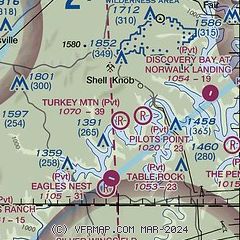
|
| Airport distance calculator |
|---|
|
|
| Sunrise and sunset |
|---|
|
Times for 07-Feb-2025
| | Local
(UTC-6) | | Zulu
(UTC) |
|---|
| Morning civil twilight | | 06:45 | | 12:45 |
| Sunrise | | 07:12 | | 13:12 |
| Sunset | | 17:46 | | 23:46 |
| Evening civil twilight | | 18:12 | | 00:12 |
|
| Current date and time |
|---|
| Zulu (UTC) | 07-Feb-2025 22:45:28 |
|---|
| Local (UTC-6) | 07-Feb-2025 16:45:28 |
|---|
|
| METAR |
|---|
KFWB
14nm NE | 072215Z AUTO 11011G18KT 10SM OVC020 07/M05 A2999 RMK AO2 TSNO
|
KBBG
23nm E | 072045Z 12012G18KT 10SM OVC024 07/M05 A3004
|
KROG
24nm SW | 072158Z 13006KT 10SM OVC015 08/04 A2999 RMK AO2 SLP156 T00830044
|
KHFJ
25nm NW | 072235Z AUTO 13010KT 10SM OVC021 07/M01 A2997 RMK AO2
|
|
| TAF |
|---|
KBBG
23nm E | 072059Z 0721/0818 11011G21KT P6SM VCSH OVC025 TEMPO 0800/0803 4SM -DZ BR OVC009 FM080300 12007KT 2SM -DZ OVC005 FM080700 11007KT 2SM BR OVC007 WS020/24045KT FM081300 25012G22KT P6SM -DZ BKN011
|
KROG
24nm SW | 071735Z 0718/0818 11012G20KT P6SM OVC018 FM071900 13011KT 6SM -DZ OVC015 FM072300 13005KT 6SM BR OVC007 TEMPO 0800/0803 2SM -DZ BR OVC005 FM080300 14006KT 4SM BR OVC003 FM080600 17011KT 3SM -DZ BR OVC004 WS020/22040KT FM081600 22013KT P6SM BKN008 BKN012
|
|
| NOTAMs |
|---|
NOTAMs are issued by the DoD/FAA and will open in a separate window not controlled by AirNav.
|
|


