FAA INFORMATION EFFECTIVE 09 JULY 2026
Location
| FAA Identifier: | N71 |
| Lat/Long: | 40-05-31.9440N 076-34-27.6790W
40-05.532400N 076-34.461317W
40.0922067,-76.5743553
(estimated) |
| Elevation: | 458 ft. / 140 m (estimated) |
| Variation: | 09W (1975) |
| From city: | 3 miles SW of central business district of the associated city |
| Time zone: | UTC -4 (UTC -5 during Standard Time) |
| Zip code: | 17547 |
Airport Operations
| Airport use: | Open to the public |
| Activation date: | 05/1947 |
| Control tower: | no |
| ARTCC: | NEW YORK CENTER |
| FSS: | WILLIAMSPORT FLIGHT SERVICE STATION |
| NOTAMs facility: | IPT (NOTAM-D service available) |
| Attendance: | MON-FRI 0800-1630, ALL SAT UNATTND, ALL SUN UNATTND |
| Wind indicator: | yes |
| Segmented circle: | no |
| Lights: | ACTVT MIRL RWY 10/28 - CTAF. |
| Beacon: | white-green (lighted land airport)
ACTVT ROTG BCN - CTAF |
Airport Communications
| CTAF/UNICOM: | 122.8 |
| HARRISBURG APPROACH: | 126.45 |
| HARRISBURG DEPARTURE: | 126.45 |
| CLEARANCE DELIVERY: | 127.05 |
| WX ASOS at MDT (11 nm NW): | PHONE 717-944-1372 |
| WX ASOS at LNS (13 nm E): | 125.675 (717-568-6942) |
| WX ASOS at CXY (15 nm NW): | PHONE 717-216-0264 |
| WX ASOS at THV (17 nm SW): | 119.275 (717-792-5529) |
| WX AWOS-2 at 9D4 (19 nm NE): | 118.45 (717-866-2906) |
Nearby radio navigation aids
| VOR radial/distance | | VOR name | | Freq | | Var |
|---|
| LRPr272/13.1 | | LANCASTER VOR/DME | | 117.30 | | 09W |
| HARr129/26.0 | | HARRISBURG VORTAC | | 115.35 | | 10W |
| RAVr189/27.7 | | RAVINE VORTAC | | 114.60 | | 11W |
| NDB name | | Hdg/Dist | | Freq | | Var | | ID |
|---|
| BELLGROVE | | 193/20.6 | | 328 | | 10W | | BZJ | -... --.. .--- |
Airport Services
| Fuel available: | 100LL |
| Parking: | tiedowns |
| Airframe service: | MAJOR |
| Powerplant service: | NONE |
| Bottled oxygen: | NONE |
| Bulk oxygen: | NONE |
Runway Information
Runway 10/28
| Dimensions: | 3250 x 50 ft. / 991 x 15 m |
| Surface: | asphalt, in good condition |
| Weight bearing capacity: | |
| Runway edge lights: | medium intensity |
| RUNWAY 10 | | RUNWAY 28 |
| Latitude: | 40-05.508200N | | 40-05.557200N |
| Longitude: | 076-34.809183W | | 076-34.115083W |
| Elevation: | 458.0 ft. | | 400.0 ft. |
| Traffic pattern: | left | | left |
| Runway heading: | 094 magnetic, 085 true | | 274 magnetic, 265 true |
| Displaced threshold: | 300 ft.
RWY 10 DTHR BAR 300 FT FM RWY END, DTHR LGTS 300 FT FM RWY END. | | no |
| Markings: | nonprecision, in good condition | | nonprecision, in good condition |
| Touchdown point: | yes, no lights | | yes, no lights |
| Obstructions: | 35 ft. pole, 606 ft. from runway, 244 ft. left of centerline, 11:1 slope to clear
RWY 10; 15 FT ROAD 16 FT FM RWY END. | | none |
Airport Ownership and Management from official FAA records
| Ownership: | Privately-owned |
| Owner: | N71, INC.
186 AIRPORT RD
MARIETTA, PA 17547
Phone 717-928-4360 |
| Manager: | BENJAMIN TRAVIS
186 AIRPORT RD
MARIETTA, PA 17547
Phone 717-928-4360 |
Additional Remarks
| - | FOR CD CTC HARRISBURG APCH AT 800-932-0712. |
Instrument Procedures
NOTE: All procedures below are presented as PDF files. If you need a reader for these files, you should download the free Adobe Reader.NOT FOR NAVIGATION. Please procure official charts for flight.
FAA instrument procedures published for use from 09 July 2026 at 0901Z to 06 August 2026 at 0900Z.
IAPs - Instrument Approach Procedures |
|---|
| RNAV (GPS) RWY 28 | |
download (180KB) |
| VOR RWY 28 | |
download (207KB) |
| NOTE: Special Take-Off Minimums/Departure Procedures apply | |
download (149KB) |
Other nearby airports with instrument procedures:
KMDT - Harrisburg International Airport (11 nm NW)
58N - Reigle Field Airport (12 nm N)
KLNS - Lancaster Airport (13 nm E)
KCXY - Capital City Airport (15 nm NW)
08N - Keller Brothers Airport (16 nm NE)
KTHV - York Airport (17 nm SW)
9D4 - Deck Airport (19 nm NE)
|
|

Road maps at:
MapQuest
Bing
Google
| Aerial photo |
|---|
WARNING: Photo may not be current or correct
 Looking east.
Do you have a better or more recent aerial photo of Donegal Springs Airpark that you would like to share? If so, please send us your photo.
|
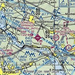
| Sectional chart |
|---|
|
| Airport distance calculator |
|---|
|
|
| Sunrise and sunset |
|---|
|
Times for 23-Jul-2026
| | Local
(UTC-4) | | Zulu
(UTC) |
|---|
| Morning civil twilight | | 05:26 | | 09:26 |
| Sunrise | | 05:57 | | 09:57 |
| Sunset | | 20:28 | | 00:28 |
| Evening civil twilight | | 20:59 | | 00:59 |
|
| Current date and time |
|---|
| Zulu (UTC) | 23-Jul-2026 12:47:38 |
|---|
| Local (UTC-4) | 23-Jul-2026 08:47:38 |
|---|
|
| METAR |
|---|
KMDT
11nm NW | 231156Z 31005KT 10SM FEW250 18/12 A3014 RMK AO2 SLP206 T01830122 10189 20161 53023
|
KLNS
13nm E | 231153Z 30004KT 10SM CLR 17/12 A3014 RMK AO2 SLP205 T01720122 10178 20133 53025
|
KCXY
15nm NW | 231156Z 24006KT 10SM CLR 18/12 A3015 RMK AO2 SLP209 T01780122 10189 20144 53023
|
KTHV
18nm SW | 231153Z AUTO 31004KT 10SM CLR 17/13 A3016 RMK AO2 SLP211 T01720128 10178 20117 53025
|
KMUI
19nm N | 231155Z 35005KT 10SM FEW250 19/10 A3013 RMK AO2A SLP203 T01910101 10209 20157 52024
|
|
| TAF |
|---|
KMDT
11nm NW | 231120Z 2312/2412 32005KT P6SM SKC FM240000 VRB02KT P6SM SKC
|
KLNS
13nm E | 231120Z 2312/2412 33005KT P6SM SKC FM240000 VRB02KT P6SM SKC
|
KMUI
19nm N | 231100Z 2311/2417 35009KT 9999 SKC QNH3009INS TX26/2322Z TN12/2410Z
|
|
| NOTAMs |
|---|
NOTAMs are issued by the DoD/FAA and will open in a separate window not controlled by AirNav.
|
|

