FAA INFORMATION EFFECTIVE 09 JULY 2026
Location
| FAA Identifier: | N81 |
| Lat/Long: | 39-40-02.9000N 074-45-27.8000W
39-40.048333N 074-45.463333W
39.6674722,-74.7577222
(estimated) |
| Elevation: | 64.6 ft. / 19.7 m (surveyed) |
| Variation: | 13W (2000) |
| From city: | 3 miles NE of HAMMONTON, NJ |
| Time zone: | UTC -4 (UTC -5 during Standard Time) |
| Zip code: | 08037 |
Airport Operations
| Airport use: | Open to the public |
| Activation date: | 12/1969 |
| Control tower: | no |
| ARTCC: | WASHINGTON CENTER |
| FSS: | MILLVILLE FLIGHT SERVICE STATION |
| NOTAMs facility: | MIV (NOTAM-D service available) |
| Attendance: | 0800-DUSK |
| Wind indicator: | lighted |
| Segmented circle: | no |
| Lights: | ACTVT REIL RWY 03 & 21; MIRL RWY 03/21 - 123.5. VGSI CONS. |
| Beacon: | white-green (lighted land airport)
Operates sunset to sunrise. |
Airport Communications
| CTAF/UNICOM: | 122.7 |
| WX AWOS-AV: | 122.7 |
| ATLANTIC CITY APPROACH: | 134.25 |
| ATLANTIC CITY DEPARTURE: | 134.25 |
| WX ASOS at ACY (15 nm SE): | PHONE 609-277-2644 |
| WX ASOS at VAY (17 nm N): | 119.325 (609-267-1176) |
- AUTOMATED UNICOM; 3 CLICKS WX ADZY.
Nearby radio navigation aids
| VOR radial/distance | | VOR name | | Freq | | Var |
|---|
| VCNr061/12.4 | | CEDAR LAKE VOR/DME | | 115.20 | | 10W |
| ACYr337/15.2 | | ATLANTIC CITY VORTAC | | 117.15 | | 10W |
| CYNr249/17.5 | | COYLE VORTAC | | 113.40 | | 10W |
| GXUr212/21.8 | | MC GUIRE VORTAC | | 110.60 | | 12W |
| OODr096/25.3 | | WOODSTOWN VORTAC | | 112.80 | | 10W |
| RBVr211/34.3 | | ROBBINSVILLE VORTAC | | 113.80 | | 10W |
| SIEr012/34.4 | | SEA ISLE VORTAC | | 114.80 | | 09W |
| ARDr179/35.8 | | YARDLEY VOR/DME | | 108.20 | | 10W |
| DQOr101/39.2 | | DUPONT VORTAC | | 114.00 | | 10W |
| NDB name | | Hdg/Dist | | Freq | | Var | | ID |
|---|
| RAINBOW | | 060/23.0 | | 363 | | 11W | | RNB | .-. -. -... |
| LAKEHURST | | 232/29.8 | | 396 | | 11W | | NEL | -. . .-.. |
Airport Services
| Fuel available: | 100LL JET-A |
| Parking: | hangars and tiedowns |
| Airframe service: | MAJOR |
| Powerplant service: | MAJOR |
| Bottled oxygen: | NONE |
| Bulk oxygen: | NONE |
Runway Information
Runway 3/21
| Dimensions: | 3601 x 75 ft. / 1098 x 23 m |
| Surface: | asphalt, in good condition |
| Weight bearing capacity: | |
| Runway edge lights: | medium intensity |
| RUNWAY 3 | | RUNWAY 21 |
| Latitude: | 39-39.763368N | | 39-40.333083N |
| Longitude: | 074-45.570430W | | 074-45.357193W |
| Elevation: | 64.1 ft. | | 57.5 ft. |
| Traffic pattern: | left | | left |
| Runway heading: | 029 magnetic, 016 true | | 209 magnetic, 196 true |
| Markings: | nonprecision, in fair condition | | nonprecision, in fair condition |
| Visual slope indicator: | 2-light PAPI on left (3.50 degrees glide path) | | 2-light PAPI on left (3.25 degrees glide path) |
| Runway end identifier lights: | yes | | yes |
| Touchdown point: | yes, no lights | | yes, no lights |
| Obstructions: | 61 ft. trees, 725 ft. from runway, 270 ft. right of centerline, 8:1 slope to clear
+30 FT TREES 190-240 FT L 70-170 FT FROM THLD. | | 40 ft. trees, 210 ft. from runway, 150 ft. right of centerline
+50 FT TREES 150 FT R 0-200 FT FROM THLD. |
Airport Ownership and Management from official FAA records
| Ownership: | Publicly-owned |
| Owner: | TOWN OF HAMMONTON
TOWN HALL, 100 CENTRAL AVENUE
HAMMONTON, NJ 08037
Phone (609) 567-4300
EXT 121. |
| Manager: | FRANK ZUBER
TOWN HALL, 100 CENTRAL AVENUE
HAMMONTON, NJ 08037
Phone (609) 567-4300
EXT 121. |
Additional Remarks
| - | GCO AVBL ON FREQ 121.725. |
| - | ON ARPT MAINT CTC 609-567-5300. |
| - | RWY 03; PARALLEL DITCH FIRST 500 FT OF RWY R SIDE WITHIN 100 FT OF CTLN. |
| - | DEER & BIRDS ON & INVOF ARPT. |
Instrument Procedures
NOTE: All procedures below are presented as PDF files. If you need a reader for these files, you should download the free Adobe Reader.NOT FOR NAVIGATION. Please procure official charts for flight.
FAA instrument procedures published for use from 09 July 2026 at 0901Z to 06 August 2026 at 0900Z.
IAPs - Instrument Approach Procedures |
|---|
| RNAV (GPS) RWY 03 | |
download (211KB) |
| VOR-B | |
download (177KB) |
| NOTE: Special Take-Off Minimums/Departure Procedures apply | |
download (150KB) |
Other nearby airports with instrument procedures:
19N - Pine Valley Airport (11 nm NW)
17N - Cross Keys Airport (13 nm W)
KACY - Atlantic City International Airport (15 nm SE)
N14 - Flying W Airport (16 nm N)
KVAY - South Jersey Regional Airport (17 nm N)
|
|

Road maps at:
MapQuest
Bing
Google
| Aerial photo |
|---|
WARNING: Photo may not be current or correct
 Photo courtesy of AirNav, LLC
Photo taken 01-Mar-2014
looking north-northeast.
Photo courtesy of AirNav, LLC
Photo taken 01-Mar-2014
looking north-northeast.
Do you have a better or more recent aerial photo of Hammonton Municipal Airport that you would like to share? If so, please send us your photo.
|
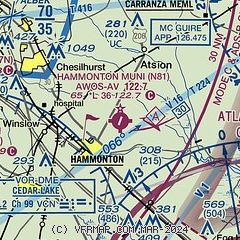
| Sectional chart |
|---|
|
| Airport distance calculator |
|---|
|
|
| Sunrise and sunset |
|---|
|
Times for 13-Jul-2026
| | Local
(UTC-4) | | Zulu
(UTC) |
|---|
| Morning civil twilight | | 05:11 | | 09:11 |
| Sunrise | | 05:43 | | 09:43 |
| Sunset | | 20:26 | | 00:26 |
| Evening civil twilight | | 20:58 | | 00:58 |
|
| Current date and time |
|---|
| Zulu (UTC) | 13-Jul-2026 05:33:06 |
|---|
| Local (UTC-4) | 13-Jul-2026 01:33:06 |
|---|
|
| METAR |
|---|
KACY
14nm SE | 130454Z RMK AO2 SLPNO $
|
KVAY
16nm N | ASOS 119.325 609-267-1176
130454Z AUTO 00000KT 10SM BKN070 18/17 A3021 RMK AO2 SLP230 T01830167 402940178
|
KWRI
22nm N | 130455Z 00000KT 10SM BKN060 18/16 A3022 RMK AO2A SLP232 T01840158 402990182 PWINO $
|
KMIV
24nm SW | 130454Z AUTO 00000KT 10SM CLR 18/17 A3021 RMK AO2 SLP228 T01780172 402890172
|
KPHL
25nm NW | 130454Z 00000KT 10SM SCT070 BKN110 23/17 A3022 RMK AO2 SLP232 T02280172 403110222 $
|
KMJX
27nm NE | AWOS-3 119.875 732-244-4450
130456Z AUTO 00000KT 10SM CLR 16/14 A3023 RMK AO2 SLP240 T01610144 402890156 $
|
KPNE
28nm NW | 130454Z 00000KT 10SM CLR 22/16 A3023 RMK AO2 SLP234 T02220156 402940189
|
|
| TAF |
|---|
KACY
14nm SE | 121720Z 1218/1318 14012KT P6SM SCT250 FM130100 15004KT P6SM SCT250 FM131400 16009KT P6SM SCT250 AMD NOT SKED
|
|
| NOTAMs |
|---|
NOTAMs are issued by the DoD/FAA and will open in a separate window not controlled by AirNav.
|
|

