FAA INFORMATION EFFECTIVE 30 OCTOBER 2025
Location
| FAA Identifier: | OSA |
| Lat/Long: | 33-05-48.8000N 094-57-42.3000W
33-05.813333N 094-57.705000W
33.0968889,-94.9617500
(estimated) |
| Elevation: | 364.2 ft. / 111.0 m (surveyed) |
| Variation: | 04E (2000) |
| From city: | 3 miles S of MOUNT PLEASANT, TX |
| Time zone: | UTC -5 (UTC -6 during Standard Time) |
| Zip code: | 75455 |
Airport Operations
| Airport use: | Open to the public |
| Activation date: | 07/2002 |
| Control tower: | no |
| ARTCC: | FORT WORTH CENTER |
| FSS: | FORT WORTH FLIGHT SERVICE STATION |
| NOTAMs facility: | OSA (NOTAM-D service available) |
| Attendance: | 0700-1800 |
| Wind indicator: | lighted |
| Segmented circle: | yes |
| Lights: | REIL RWY 17 & 35, MIRL RWY 17/35 PRE-SET ON LOW SS-SR. TO ACTVT DAYTIME & INCR INTST - CTAF. PAPI RWY 17 & 35 OPR CONSLY. |
| Beacon: | white-green (lighted land airport)
Operates sunset to sunrise. |
Airport Communications
| CTAF/UNICOM: | 122.7 |
| WX AWOS-3: | 119.775 (903-575-4027) |
- APCH/DEP SVC PRVDD BY FORT WORTH ARTCC (ZFW) ON FREQS 132.025/317.75 (CUMBY RCAG).
Nearby radio navigation aids
| VOR radial/distance | | VOR name | | Freq | | Var |
|---|
| PRXr131/36.2 | | PARIS VOR/DME | | 113.60 | | 07E |
| NDB name | | Hdg/Dist | | Freq | | Var | | ID |
|---|
| AMBASSADOR | | 007/31.6 | | 404 | | 07E | | ABG | .- -... --. |
| ATLANTA | | 265/38.8 | | 347 | | 04E | | ATA | .- - .- |
Airport Services
| Fuel available: | 100LL JET-A
100LL:FOR JET A AFT HRS CALL 903-575-4004. 100LL AVBL 24 HRS SELF SERV. |
| Parking: | hangars and tiedowns |
| Airframe service: | MAJOR |
| Powerplant service: | MAJOR |
Runway Information
Runway 17/35
| Dimensions: | 6004 x 100 ft. / 1830 x 30 m |
| Surface: | asphalt, in good condition |
| Weight bearing capacity: | |
| Runway edge lights: | medium intensity |
| Runway edge markings: | MKGS DISCOLORED. |
| RUNWAY 17 | | RUNWAY 35 |
| Latitude: | 33-06.303693N | | 33-05.323433N |
| Longitude: | 094-57.787470W | | 094-57.623048W |
| Elevation: | 364.2 ft. | | 341.5 ft. |
| Traffic pattern: | left | | left |
| Runway heading: | 168 magnetic, 172 true | | 348 magnetic, 352 true |
| Markings: | nonprecision, in poor condition | | nonprecision, in poor condition |
| Visual slope indicator: | 4-light PAPI on left (3.00 degrees glide path) | | 4-light PAPI on left (3.00 degrees glide path) |
| Runway end identifier lights: | yes | | yes |
| Touchdown point: | yes, no lights | | yes, no lights |
| Obstructions: | none | | 80 ft. trees, 2300 ft. from runway, 30 ft. right of centerline, 26:1 slope to clear |
Helipad H1
| Dimensions: | 44 x 44 ft. / 13 x 13 m |
| Surface: | concrete, in fair condition |
| Runway edge markings: | MKGS DISCOLORED. |
| Latitude: | 33-05.840500N | | |
| Longitude: | 094-57.803167W | | |
| Elevation: | 364.2 ft. | | |
| Traffic pattern: | left | | left |
| Markings: | basic, in poor condition | | |
Airport Ownership and Management from official FAA records
| Ownership: | Publicly-owned |
| Owner: | CITY OF MOUNT PLEASANT
501 NORTH MADISON
MOUNT PLEASANT, TX 75455
Phone 903-575-4000 |
| Manager: | PAUL HENDERSON
501 MIKE HALL PARKWAY
MOUNT PLEASANT, TX 75455
Phone 903-575-4020
PHENDERSON@MPCITY.ORG |
Additional Remarks
| A52-H1 | 59 FT BCN 285 FT W AND 33 FT BLDG 256 FT W. |
| - | DEER & WILDLIFE ON & INVOF ARPT. |
| - | NO LINE OF SIGHT BETWEEN RWY ENDS. |
| - | FOR CD CTC FORT WORTH ARTCC AT 817-858-7584. |
Instrument Procedures
NOTE: All procedures below are presented as PDF files. If you need a reader for these files, you should download the free Adobe Reader.NOT FOR NAVIGATION. Please procure official charts for flight.
FAA instrument procedures published for use from 30 October 2025 at 0901Z to 27 November 2025 at 0900Z.
IAPs - Instrument Approach Procedures |
|---|
| RNAV (GPS) RWY 17 | |
download (237KB) |
| RNAV (GPS) RWY 35 | |
download (241KB) |
| NOTE: Special Alternate Minimums apply | |
download (139KB) |
| NOTE: Special Take-Off Minimums/Departure Procedures apply | |
download (113KB) |
Other nearby airports with instrument procedures:
F53 - Franklin County Airport (16 nm NW)
F51 - Winnsboro Municipal Airport (19 nm SW)
KJXI - Fox Stephens Field/Gilmer Municipal Airport (24 nm S)
KSLR - Sulphur Springs Municipal Airport (33 nm W)
07F - Gladewater Municipal Airport (34 nm S)
|
|

Road maps at:
MapQuest
Bing
Google
| Aerial photo |
|---|
WARNING: Photo may not be current or correct
 Taken in October 2008
Do you have a better or more recent aerial photo of Mount Pleasant Regional Airport that you would like to share? If so, please send us your photo.
|
| Sectional chart |
|---|
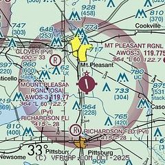
|
| Airport distance calculator |
|---|
|
|
| Sunrise and sunset |
|---|
|
Times for 30-Oct-2025
| | Local
(UTC-5) | | Zulu
(UTC) |
|---|
| Morning civil twilight | | 07:12 | | 12:12 |
| Sunrise | | 07:37 | | 12:37 |
| Sunset | | 18:30 | | 23:30 |
| Evening civil twilight | | 18:55 | | 23:55 |
|
| Current date and time |
|---|
| Zulu (UTC) | 31-Oct-2025 04:05:33 |
|---|
| Local (UTC-5) | 30-Oct-2025 23:05:33 |
|---|
|
| METAR |
|---|
| KOSA | 310355Z AUTO 00000KT 10SM 08/07 A3010 RMK AO2 T00800068
|
|
| TAF |
|---|
KGGG
45nm S | 301720Z 3018/3118 33008KT P6SM SKC FM310000 00000KT P6SM SKC FM311200 00000KT P6SM SKC
|
KTYR
49nm SW | 301720Z 3018/3118 32008KT P6SM SKC FM310000 29003KT P6SM SKC FM311200 00000KT P6SM SKC
|
|
| NOTAMs |
|---|
NOTAMs are issued by the DoD/FAA and will open in a separate window not controlled by AirNav.
|
|

