FAA INFORMATION EFFECTIVE 16 APRIL 2026
Location
| FAA Identifier: | OWX |
| Lat/Long: | 41-02-08.1420N 083-58-54.8170W
41-02.135700N 083-58.913617W
41.0355950,-83.9818936
(estimated) |
| Elevation: | 763.5 ft. / 232.7 m (surveyed) |
| Variation: | 05W (1990) |
| From city: | 3 miles NE of OTTAWA, OH |
| Time zone: | UTC -4 (UTC -5 during Standard Time) |
| Zip code: | 45875 |
Airport Operations
| Airport use: | Open to the public |
| Activation date: | 10/1967 |
| Control tower: | no |
| ARTCC: | CLEVELAND CENTER |
| FSS: | CLEVELAND FLIGHT SERVICE STATION |
| NOTAMs facility: | OWX (NOTAM-D service available) |
| Attendance: | MON-FRI 0900-1700
FOR SVC ALL HRS CALL AMGR. |
| Wind indicator: | lighted |
| Segmented circle: | no |
| Lights: | ACTVT REIL RWY 09 & 27; MIRL RWY 09/27 - CTAF. PAPI RWY 09 & 27 OPR CONSLY. |
| Beacon: | white-green (lighted land airport)
Operates sunset to sunrise. |
Airport Communications
| CTAF/UNICOM: | 122.7 |
| WX AWOS-3: | 120.525 (419-523-4151) |
| TOLEDO APPROACH: | 120.8 |
| TOLEDO DEPARTURE: | 120.8 |
| WX ASOS at FDY (14 nm E): | 132.85 (419-427-8524) |
| WX ASOS at AOH (20 nm S): | 128.725 (419-224-6098) |
Nearby radio navigation aids
| VOR radial/distance | | VOR name | | Freq | | Var |
|---|
| FBCr297/11.3 | | FLAG CITY VORTAC | | 108.20 | | 02W |
| NDB name | | Hdg/Dist | | Freq | | Var | | ID |
|---|
| TIFFIN | | 269/34.9 | | 269 | | 05W | | TII | - .. .. |
Airport Services
| Fuel available: | 100LL JET-A+
100LL:FUEL AVBL H24 SELF SVC. |
| Parking: | hangars and tiedowns |
| Airframe service: | NONE |
| Powerplant service: | NONE |
| Bottled oxygen: | NONE |
| Bulk oxygen: | NONE |
Runway Information
Runway 9/27
| Dimensions: | 4502 x 75 ft. / 1372 x 23 m |
| Surface: | asphalt, in fair condition |
| Runway edge lights: | medium intensity |
| RUNWAY 9 | | RUNWAY 27 |
| Latitude: | 41-02.133833N | | 41-02.137535N |
| Longitude: | 083-59.403187W | | 083-58.424052W |
| Elevation: | 754.1 ft. | | 763.5 ft. |
| Traffic pattern: | left | | left |
| Runway heading: | 095 magnetic, 090 true | | 275 magnetic, 270 true |
| Markings: | nonprecision, in good condition | | nonprecision, in good condition |
| Visual slope indicator: | 2-light PAPI on left (3.00 degrees glide path) | | 2-light PAPI on left (3.00 degrees glide path) |
| Runway end identifier lights: | yes | | yes |
| Touchdown point: | yes, no lights | | yes, no lights |
| Obstructions: | 16 ft. road, 201 ft. from runway, 217 ft. left of centerline
+9 FT ROAD, 0-200 FT DIST, 217 FT L. | | 11 ft. road, 201 ft. from runway, 208 ft. right of centerline
+11 FT ROAD, 0-200 FT DIST, 208 FT R. |
Airport Ownership and Management from official FAA records
| Ownership: | Publicly-owned |
| Owner: | PUTNAM CO ARPT AUTHORITY
10218 ROAD 5-H
OTTAWA, OH 45875-9715
Phone 419-523-3910 |
| Manager: | CHAD & LINDA NIESE
10218 ROAD 5-H
OTTAWA, OH 45875-9715
Phone 419-523-3910 |
Additional Remarks
| - | INTENSIVE AGRI OPNS & CROP DUSTING. |
| - | FOR CD CTC TOLEDO APCH AT 419-865-1495. |
Instrument Procedures
NOTE: All procedures below are presented as PDF files. If you need a reader for these files, you should download the free Adobe Reader.NOT FOR NAVIGATION. Please procure official charts for flight.
FAA instrument procedures published for use from 16 April 2026 at 0901Z to 14 May 2026 at 0900Z.
IAPs - Instrument Approach Procedures |
|---|
| RNAV (GPS) RWY 09 | |
download (206KB) |
| RNAV (GPS) RWY 27 | |
download (192KB) |
| VOR RWY 27 | |
download (177KB) |
| NOTE: Special Take-Off Minimums/Departure Procedures apply | |
download (164KB) |
Other nearby airports with instrument procedures:
5G7 - Bluffton Airport (10 nm SE)
KFDY - Findlay Airport (14 nm E)
KAOH - Lima Allen County Airport (20 nm S)
7W5 - Henry County Airport (21 nm N)
1G0 - Wood County Airport (27 nm NE)
|
|

Road maps at:
MapQuest
Bing
Google
| Aerial photo |
|---|
WARNING: Photo may not be current or correct

Do you have a better or more recent aerial photo of Putnam County Airport that you would like to share? If so, please send us your photo.
|
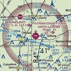
| Sectional chart |
|---|
|
| Airport distance calculator |
|---|
|
|
| Sunrise and sunset |
|---|
|
Times for 17-Apr-2026
| | Local
(UTC-4) | | Zulu
(UTC) |
|---|
| Morning civil twilight | | 06:26 | | 10:26 |
| Sunrise | | 06:55 | | 10:55 |
| Sunset | | 20:16 | | 00:16 |
| Evening civil twilight | | 20:45 | | 00:45 |
|
| Current date and time |
|---|
| Zulu (UTC) | 17-Apr-2026 13:00:23 |
|---|
| Local (UTC-4) | 17-Apr-2026 09:00:23 |
|---|
|
| METAR |
|---|
| KOWX | 171235Z AUTO 21003KT M1/4SM FG OVC001 12/12 A3002 RMK AO2
|
KFDY
14nm E | 171253Z AUTO 00000KT 1SM BR VV002 13/13 A3000 RMK AO2 SLP154 T01330133
|
|
| TAF |
|---|
KFDY
14nm E | 171124Z 1712/1812 VRB03KT 1/4SM FG BKN004 FM171400 11004KT 5SM BR SCT250 FM171500 16006KT P6SM SKC FM180000 14009KT P6SM BKN250 FM180600 17013G18KT P6SM BKN100 FM180900 18017G24KT P6SM -SHRA OVC050
|
|
| NOTAMs |
|---|
NOTAMs are issued by the DoD/FAA and will open in a separate window not controlled by AirNav.
|
|


