FAA INFORMATION EFFECTIVE 11 JUNE 2026
Location
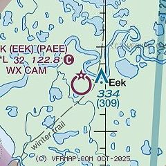
| FAA Identifier: | EEK |
| Lat/Long: | 60-12-49.3000N 162-02-38.0000W
60-12.821667N 162-02.633333W
60.2136944,-162.0438889
(estimated) |
| Elevation: | 26.5 ft. / 8.1 m (surveyed) |
| Variation: | 11E (2020) |
| From city: | 1 mile W of EEK, AK |
| Time zone: | UTC -8 (UTC -9 during Standard Time) |
| Zip code: | 99578 |
Airport Operations
| Airport use: | Open to the public |
| Activation date: | 06/1974 |
| Control tower: | no |
| ARTCC: | ANCHORAGE CENTER |
| FSS: | KENAI FLIGHT SERVICE STATION [907-283-7211] |
| NOTAMs facility: | ENA (NOTAM-D service available) |
| Attendance: | UNATNDD |
| Wind indicator: | lighted |
| Segmented circle: | yes |
| Lights: | ACTVT REIL RWY 18, 36; PAPI RWY 18, 36; MIRL RWY 18/36 - CTAF. |
| Beacon: | white-green (lighted land airport)
Operates sunset to sunrise. |
Airport Communications
- APCH/DEP SVC PRVDD BY ANCHORAGE ARTCC (ZAN) ON 125.2/372.0 (BETHEL RCAG).
Nearby radio navigation aids
| VOR radial/distance | | VOR name | | Freq | | Var |
|---|
| BETr177/34.9 | | BETHEL VORTAC | | 114.10 | | 14E |
| NDB name | | Hdg/Dist | | Freq | | Var | | ID |
|---|
| OSCARVILLE | | 177/35.0 | | 251 | | 11E | | OSE | --- ... . |
Airport Services
| Airframe service: | NONE |
| Powerplant service: | NONE |
| Bottled oxygen: | NONE |
| Bulk oxygen: | NONE |
Runway Information
Runway 18/36
| Dimensions: | 3242 x 60 ft. / 988 x 18 m |
| Surface: | gravel, in good condition |
| Runway edge lights: | medium intensity
GRASS AND BRUSH SURROUNDS RWY LGTS. |
| RUNWAY 18 | | RUNWAY 36 |
| Latitude: | 60-13.084597N | | 60-12.559118N |
| Longitude: | 162-02.549567W | | 162-02.718668W |
| Elevation: | 25.2 ft. | | 23.1 ft. |
| Traffic pattern: | left | | left |
| Runway heading: | 178 magnetic, 189 true | | 358 magnetic, 009 true |
| Markings: | , in good condition | | , in good condition |
| Visual slope indicator: | 4-light PAPI on left (3.00 degrees glide path) | | 4-light PAPI on left (3.00 degrees glide path) |
| Runway end identifier lights: | yes | | yes |
| Touchdown point: | yes, no lights | | yes, no lights |
| Obstructions: | 3 ft. brush, 8 ft. from runway, 58 ft. right of centerline, 2:1 slope to clear | | 5 ft. brush, 10 ft. from runway, 60 ft. left and right of centerline, 2:1 slope to clear |
Airport Ownership and Management from official FAA records
| Ownership: | Publicly-owned |
| Owner: | ALASKA DOT&PF CENTRAL REGION
PO BOX 196900
ANCHORAGE, AK 99519-6900
Phone (907) 269-0783 |
| Manager: | JOSEPH LARAUX
BOX 505
BETHEL, AK 99559
Phone (907) 543-2498 |
Additional Remarks
| - | RWY CONDITION NOT MONITORED; RECOMMEND VISUAL INSPECTION PRIOR TO USING. |
| - | WX CAMERA AVBL ON INTERNET AT HTTPS://WEATHERCAMS.FAA.GOV |
| - | BIRDS INVOF ARPT. |
| - | 300 FT TOWER APPX 1.1 MILES EAST OF ARPT. |
| - | 6-8 IN DIPS IN RWY FULL LENGTH. |
Instrument Procedures
NOTE: All procedures below are presented as PDF files. If you need a reader for these files, you should download the free Adobe Reader.NOT FOR NAVIGATION. Please procure official charts for flight.
FAA instrument procedures published for use from 11 June 2026 at 0901Z to 09 July 2026 at 0900z.
IAPs - Instrument Approach Procedures |
|---|
| RNAV (GPS) RWY 18 | |
download (208KB) |
| RNAV (GPS) RWY 36 | |
download (204KB) |
| NOTE: Special Take-Off Minimums/Departure Procedures apply | |
download (393KB) |
Other nearby airports with instrument procedures:
PAQH - Quinhagak Airport (28 nm S)
PANA - Napakiak Airport (29 nm N)
PAPK - Napaskiak Airport (30 nm N)
PABE - Bethel Airport (34 nm N)
PFKW - Kwethluk Airport (39 nm NE)
|
|

Road maps at:
MapQuest
Bing
Google
| Aerial photo |
|---|
WARNING: Photo may not be current or correct
 Photo by Security Aviation
Photo taken 20-Dec-2017
looking south over Eek.
Photo by Security Aviation
Photo taken 20-Dec-2017
looking south over Eek.
Do you have a better or more recent aerial photo of Eek Airport that you would like to share? If so, please send us your photo.
|
| Sectional chart |
|---|
|
| Airport distance calculator |
|---|
|
|
| Sunrise and sunset |
|---|
|
Times for 01-Jul-2026
| | Local
(UTC-8) | | Zulu
(UTC) |
|---|
| Morning civil twilight | | 03:46 | | 11:46 |
| Sunrise | | 05:29 | | 13:29 |
| Sunset | | 00:15 | | 08:15 |
| Evening civil twilight | | 01:58 | | 09:58 |
|
| Current date and time |
|---|
| Zulu (UTC) | 01-Jul-2026 18:23:53 |
|---|
| Local (UTC-8) | 01-Jul-2026 10:23:53 |
|---|
|
| METAR |
|---|
PAQH
28nm S | 011756Z AUTO 09011KT 10SM BKN030 BKN035 OVC055 12/09 A2981 RMK AO2 SLP096 60001 T01170089 10117 20083 56007
|
PABE
35nm N | 011753Z 10007KT 10SM BKN055 13/07 A2983 RMK AO2 SLP101 T01330072 10139 20078 56008
|
PFZK
45nm N | 011756Z AUTO 09005KT 10SM CLR 13/08 A2982 RMK AO2 SLP096 T01330078 10133 20072 56009 $
|
|
| TAF |
|---|
PABE
35nm N | 010526Z 0106/0206 VRB05KT P6SM OVC050 FM011800 12007KT P6SM OVC050 FM020200 15008KT P6SM OVC050 FM020300 18008KT P6SM -SHRA OVC025
|
|
| NOTAMs |
|---|
NOTAMs are issued by the DoD/FAA and will open in a separate window not controlled by AirNav.
|
|

