FAA INFORMATION EFFECTIVE 20 MARCH 2025
Location
| FAA Identifier: | PSC |
| Lat/Long: | 46-15-52.8540N 119-07-08.4860W
46-15.880900N 119-07.141433W
46.2646817,-119.1190239
(estimated) |
| Elevation: | 410.4 ft. / 125.1 m (surveyed) |
| Variation: | 15E (2015) |
| From city: | 2 miles NW of PASCO, WA |
| Time zone: | UTC -7 (UTC -8 during Standard Time) |
| Zip code: | 99301 |
Airport Operations
| Airport use: | Open to the public |
| Activation date: | 11/1937 |
| Control tower: | yes |
| ARTCC: | SEATTLE CENTER |
| FSS: | SEATTLE FLIGHT SERVICE STATION |
| NOTAMs facility: | PSC (NOTAM-D service available) |
| Attendance: | 0800-2000 |
| Wind indicator: | lighted |
| Segmented circle: | yes |
| Lights: | WHEN ATCT CLSD HIRL RY 03L/21R AND MIRL RY 12/30 PRESET ON LOW INTST TO INCREASE INTST AND ACTVT MALSR RY 21R & ODALS RY 30 - CTAF. |
| Beacon: | white-green (lighted land airport)
Operates sunset to sunrise. |
| Fire and rescue: | ARFF index B |
| Airline operations: | PPR UNSKED ACR OPNS WITH MORE THAN 30 PSGR SEATS CALL AMGR 509-547-6352. |
Airport Communications
| CTAF: | 135.3 |
| UNICOM: | 122.95 |
| ATIS: | 125.65 |
| WX ASOS: | PHONE 509-547-7379 |
| TRI-CITIES GROUND: | 121.8 [0600-2200] |
| TRI-CITIES TOWER: | 135.3 323.3 [0600-2200] |
| SPOKANE APPROACH: | 128.75 ;NORTH & WEST 133.15 ;EAST & SOUTH |
| SPOKANE DEPARTURE: | 128.75 ;NORTH & WEST 133.15 ;EAST & SOUTH |
| CLEARANCE DELIVERY: | 120.0 |
| IC: | 128.75 ;NORTH & WEST |
| WX AWOS-3PT at RLD (8 nm W): | 132.675 (509-375-4247) |
- COMMUNICATIONS PRVDD BY SEATTLE RADIO ON FREQ 122.4 (JUMP-OFF-JOE RCO).
- APCH/DEP CTL SVC PROVDD BY SEATTLE ARTCC (ZSE) ON 132.6/269.35 (YAKIMA RCAG), WHEN GEG APCH CLSD.
Nearby radio navigation aids
| VOR radial/distance | | VOR name | | Freq | | Var |
|---|
| PSC at field | | PASCO VOR/DME | | 113.75 | | 15E |
| PDTr334/34.8 | | PENDLETON VORTAC | | 114.70 | | 14E |
| ALWr273/36.0 | | WALLA WALLA VOR/DME | | 116.40 | | 14E |
Airport Services
| Fuel available: | 100LL JET-A1+
100LL:AFTER HOURS FUEL CALL (509) 547-6271 OR (509) 545-5524. CALL-OUT FEE. FUEL 24 HR CREDIT CARD SVC AVBL. |
| Parking: | hangars and tiedowns |
| Airframe service: | MAJOR |
| Powerplant service: | MAJOR |
| Bottled oxygen: | NONE |
| Bulk oxygen: | LOW |
Runway Information
Runway 3L/21R
| Dimensions: | 7707 x 150 ft. / 2349 x 46 m |
| Surface: | asphalt/grooved, in good condition |
| Weight bearing capacity: | | Single wheel: | 150.0 | | Double wheel: | 200.0 | | Double tandem: | 400.0 |
|
| Runway edge lights: | high intensity |
| RUNWAY 3L | | RUNWAY 21R |
| Latitude: | 46-15.357428N | | 46-16.242537N |
| Longitude: | 119-08.009498W | | 119-06.700412W |
| Elevation: | 409.8 ft. | | 401.3 ft. |
| Traffic pattern: | left | | right |
| Runway heading: | 030 magnetic, 045 true | | 210 magnetic, 225 true |
| Displaced threshold: | no | | 597 ft. |
| Declared distances: | TORA:7707 TODA:7707 ASDA:7707 LDA:7707 | | TORA:7707 TODA:7707 ASDA:7707 LDA:7110 |
| Markings: | nonprecision, in good condition | | precision, in good condition |
| Visual slope indicator: | 4-light PAPI on left (3.00 degrees glide path) | | 4-light PAPI on left (3.00 degrees glide path) |
| RVR equipment: | rollout | | touchdown |
| Approach lights: | | | MALSR: 1,400 foot medium intensity approach lighting system with runway alignment indicator lights |
| Runway end identifier lights: | yes | | |
| Touchdown point: | yes, no lights | | yes, no lights |
| Instrument approach: | | | ILS/DME |
| Obstructions: | 61 ft. tree, 2550 ft. from runway, 750 ft. right of centerline, 38:1 slope to clear | | 49 ft. pole, 1900 ft. from runway, 450 ft. left of centerline, 34:1 slope to clear
+81' TWR 3036' & 900'L 37:1 BASED ON DSPLCD THR. |
Runway 12/30
| Dimensions: | 7704 x 150 ft. / 2348 x 46 m |
| Surface: | asphalt/grooved, in good condition |
| Weight bearing capacity: | | Single wheel: | 150.0 | | Double wheel: | 200.0 | | Double tandem: | 400.0 |
|
| Runway edge lights: | medium intensity |
| RUNWAY 12 | | RUNWAY 30 |
| Latitude: | 46-16.408507N | | 46-15.500798N |
| Longitude: | 119-07.678177W | | 119-06.402782W |
| Elevation: | 395.6 ft. | | 402.0 ft. |
| Traffic pattern: | left | | left |
| Runway heading: | 120 magnetic, 135 true | | 300 magnetic, 315 true |
| Displaced threshold: | no | | 200 ft. |
| Declared distances: | TORA:7704 TODA:7704 ASDA:7504 LDA:7504 | | TORA:7704 TODA:7704 ASDA:7704 LDA:7504 |
| Markings: | nonprecision, in good condition | | nonprecision, in good condition |
| Visual slope indicator: | 4-box VASI on left (3.00 degrees glide path) | | 4-light PAPI on left (3.00 degrees glide path) |
| Approach lights: | | | ODALS: omnidirectional approach lighting system |
| Runway end identifier lights: | yes | | |
| Touchdown point: | yes, no lights | | yes, no lights |
| Obstructions: | none | | 30 ft. tree, 1312 ft. from runway, 177 ft. left of centerline, 37:1 slope to clear |
Runway 3R/21L
| Dimensions: | 4423 x 75 ft. / 1348 x 23 m |
| Surface: | asphalt, in fair condition
RY 03R/21L SFC CRACKING. |
| Weight bearing capacity: | | PCN 13 /F/B/X/T | | Single wheel: | 52.0 | | Double wheel: | 85.0 | | Double tandem: | 108.0 | | Dual double tandem: | 150.0 |
|
| RUNWAY 3R | | RUNWAY 21L |
| Latitude: | 46-15.639268N | | 46-16.147120N |
| Longitude: | 119-07.321125W | | 119-06.569728W |
| Elevation: | 402.9 ft. | | 403.8 ft. |
| Traffic pattern: | right | | left |
| Runway heading: | 030 magnetic, 045 true | | 210 magnetic, 225 true |
| Declared distances: | TORA:4423 TODA:4423 ASDA:4423 LDA:4423 | | TORA:4423 TODA:4423 ASDA:4423 LDA:4423 |
| Markings: | basic, in good condition | | basic, in good condition |
| Touchdown point: | yes, no lights | | yes, no lights |
| Obstructions: | none | | 79 ft. tower, 2445 ft. from runway, 77 ft. left of centerline, 28:1 slope to clear |
Airport Ownership and Management from official FAA records
| Ownership: | Publicly-owned |
| Owner: | PORT OF PASCO
3601 N 20TH AVE
PASCO, WA 99301
Phone 509-547-6352 |
| Manager: | DONALD "BUCK" TAFT
3601 N 20TH AVE
PASCO, WA 99301
Phone 509-547-6352 |
Additional Remarks
| A39-12/30 | PCR VALUE: 466/F/B/X/T |
| A39-03L/21R | PCR VALUE: 384/F/B/X/U |
| - | BIRD HAZARD; SEE SPECIAL NOTICE FOR WASHINGTON IN AIM PART 3A. |
| - | TPA 1500' TURBINE PWRD ACFT; ALL OTRS 1000'. |
| - | RY 03R/21L IS AVBL FOR ACR ACFT FOR TAXIING DURING DALGT AND VFR CONDITIONS ONLY. |
| - | RY 21L & 03R NOT AVBL AS MOVEMENT AREA FOR ACR ACFT WITH MORE THAN 9 PSGR SEATS OR GREATER FOR LNDG AND TKOF. |
| - | WATER FOWL ON & INVOF ARPT SPRING & FALL. |
| - | TWY G, G1 & E2 LTD TO USE BY ACFT UP TO 100000 LBS AND LESS THAN 20 FT MAIN GEAR WID. |
Instrument Procedures
NOTE: All procedures below are presented as PDF files. If you need a reader for these files, you should download the free Adobe Reader.NOT FOR NAVIGATION. Please procure official charts for flight.
FAA instrument procedures published for use from 20 March 2025 at 0901Z to 17 April 2025 at 0900z.
IAPs - Instrument Approach Procedures |
|---|
| ILS OR LOC RWY 21R | |
download (365KB) |
| RNAV (RNP) Z RWY 03L | |
download (323KB) |
| RNAV (RNP) Z RWY 12 | |
download (288KB) |
| RNAV (RNP) Z RWY 21R | |
download (315KB) |
| RNAV (RNP) Z RWY 30 | |
download (317KB) |
| RNAV (GPS) Y RWY 03L | |
download (293KB) |
| RNAV (GPS) Y RWY 12 | |
download (285KB) |
| RNAV (GPS) Y RWY 21R | |
download (296KB) |
| RNAV (GPS) Y RWY 30 | |
download (306KB) |
| VOR RWY 21R | |
download (279KB) |
| VOR RWY 30 | |
download (313KB) |
| NOTE: Special Alternate Minimums apply | |
download (161KB) |
Departure Procedures |
|---|
| TRI-CITIES SEVEN | |
download (177KB) |
| NOTE: Special Take-Off Minimums/Departure Procedures apply | |
download |
Other nearby airports with instrument procedures:
KRLD - Richland Airport (8 nm W)
KHRI - Hermiston Municipal Airport (27 nm S)
KPDT - Eastern Oregon Regional Airport at Pendleton (36 nm S)
KALW - Walla Walla Regional Airport (36 nm E)
9S9 - Lexington Airport (54 nm SW)
|
|

Road maps at:
MapQuest
Bing
Google
| Aerial photo |
|---|
WARNING: Photo may not be current or correct
 Photo by Jack Vos
Photo taken 18-Nov-2020
looking southeast.
Photo by Jack Vos
Photo taken 18-Nov-2020
looking southeast.
Do you have a better or more recent aerial photo of Tri-Cities Airport that you would like to share? If so, please send us your photo.
|
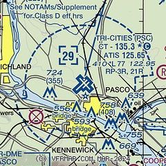
| Sectional chart |
|---|
|
CAUTION: Diagram may not be current
 Download PDF
of official airport diagram from the FAA
| Airport distance calculator |
|---|
|
|
| Sunrise and sunset |
|---|
|
Times for 30-Mar-2025
| | Local
(UTC-7) | | Zulu
(UTC) |
|---|
| Morning civil twilight | | 06:11 | | 13:11 |
| Sunrise | | 06:41 | | 13:41 |
| Sunset | | 19:21 | | 02:21 |
| Evening civil twilight | | 19:51 | | 02:51 |
|
| Current date and time |
|---|
| Zulu (UTC) | 30-Mar-2025 19:45:33 |
|---|
| Local (UTC-7) | 30-Mar-2025 12:45:33 |
|---|
|
| METAR |
|---|
| KPSC | 301853Z 32003KT 10SM CLR 11/03 A2981 RMK AO2 SLP094 T01060028 $
|
KRLD
8nm W | 301935Z AUTO 29003KT 10SM CLR 14/05 A2979 RMK AO2 T01350048
|
|
| TAF |
|---|
| KPSC | 301720Z 3018/3118 VRB05KT P6SM BKN200 FM310000 10010KT P6SM VCSH OVC080 PROB30 3102/3104 -RA FM310500 14009KT P6SM -RA OVC050 FM310800 19007KT P6SM BKN050 FM311600 19008KT P6SM -RA OVC050
|
|
| NOTAMs |
|---|
NOTAMs are issued by the DoD/FAA and will open in a separate window not controlled by AirNav.
|
|


