FAA INFORMATION EFFECTIVE 27 NOVEMBER 2025
Location
| FAA Identifier: | ROG |
| Lat/Long: | 36-22-20.7000N 094-06-25.1000W
36-22.345000N 094-06.418333W
36.3724167,-94.1069722
(estimated) |
| Elevation: | 1358.8 ft. / 414.2 m (surveyed) |
| Variation: | 01E (2025) |
| From city: | 2 miles N of ROGERS, AR |
| Time zone: | UTC -6 (UTC -5 during Daylight Saving Time) |
| Zip code: | 72756 |
Airport Operations
| Airport use: | Open to the public |
| Activation date: | 05/1946 |
| Control tower: | yes |
| ARTCC: | MEMPHIS CENTER |
| FSS: | JONESBORO FLIGHT SERVICE STATION |
| NOTAMs facility: | ROG (NOTAM-D service available) |
| Attendance: | MON-FRI 0400-2100, ALL SAT-SUN 0700-1900 |
| Pattern altitude: | 2357.8 ft. MSL |
| Wind indicator: | lighted |
| Segmented circle: | yes |
| Lights: | WHEN ATCT CLSD ACTVT HIRL RY 02/20, REIL RY 02, TWY LGTS & MALSR RY 20, PAPI RY 02&20- CTAF. |
| Beacon: | white-green (lighted land airport)
Operates sunset to sunrise. |
| International operations: | US CUSTOMS USER FEE ARPT. |
Airport Communications
| CTAF: | 119.375 |
| WX AWOS-3PT: | 134.375 (479-631-9196) |
| ROGERS GROUND: | 118.0 [0530-1930 MON-FRI; 0800-1900 SAT-SUN] |
| ROGERS TOWER: | 119.375 [0530-1930 MON-FRI; 0800-1900 SAT-SUN] |
| RAZORBACK APPROACH: | 126.6 |
| RAZORBACK DEPARTURE: | 126.6 |
| CLEARANCE DELIVERY: | 121.75 ;WHEN TWR CLSD 121.75 |
| WX AWOS-3PT at VBT (6 nm W): | 134.975 (479-273-9198) |
| WX ASOS at XNA (11 nm SW): | 119.425 (479-203-0109) |
| WX AWOS-3 at ASG (12 nm S): | 124.675 (479-750-2967) |
- APCH/DEP SVC PRVDD BY MEMPHIS ARTCC ON FREQS 126.1/269.0 (FAYETTEVILLE RCAG) WHEN RAZORBACK APCH CTL CLSD.
Nearby radio navigation aids
| VOR radial/distance | | VOR name | | Freq | | Var |
|---|
| RZCr001/7.6 | | RAZORBACK VORTAC | | 116.40 | | 04E |
| NDB name | | Hdg/Dist | | Freq | | Var | | ID |
|---|
| SILOAM SPRINGS | | 055/21.5 | | 284 | | 04E | | SLG | ... .-.. --. |
Airport Services
| Fuel available: | 100LL JET-A
100LL:FOR FUEL AFT HRS CALL 479-636-9400; FEE CHARGED. |
| Parking: | hangars and tiedowns |
| Airframe service: | MAJOR |
| Powerplant service: | MAJOR |
| Bottled oxygen: | HIGH |
| Bulk oxygen: | NONE |
Runway Information
Runway 2/20
| Dimensions: | 6011 x 100 ft. / 1832 x 30 m |
| Surface: | asphalt/grooved, in good condition |
| Weight bearing capacity: | | PCN 42 /F/B/X/T | | Single wheel: | 45.0 | | Double wheel: | 100.0 |
|
| Runway edge lights: | high intensity |
| RUNWAY 2 | | RUNWAY 20 |
| Latitude: | 36-21.876672N | | 36-22.812478N |
| Longitude: | 094-06.618925W | | 094-06.216913W |
| Elevation: | 1358.7 ft. | | 1339.9 ft. |
| Traffic pattern: | left | | left |
| Runway heading: | 018 magnetic, 019 true | | 198 magnetic, 199 true |
| Markings: | precision, in good condition | | precision, in good condition |
| Visual slope indicator: | 4-light PAPI on left (3.00 degrees glide path) | | 4-light PAPI on left (3.00 degrees glide path) |
| Approach lights: | | | MALSR: 1,400 foot medium intensity approach lighting system with runway alignment indicator lights |
| Runway end identifier lights: | yes | | |
| Touchdown point: | yes, no lights | | yes, no lights |
| Instrument approach: | | | ILS/DME |
Airport Ownership and Management from official FAA records
| Ownership: | Publicly-owned |
| Owner: | CITY OF ROGERS
301 WEST CHESTNUT
ROGERS, AR 72756
Phone (479) 631-1400 |
| Manager: | DAVID KRUTSCH
#3 SOUTH AIRPORT DRIVE
ROGERS, AR 72756
Phone 479-631-1400 |
Additional Remarks
| - | ARFF AVBL UPON REQUEST. |
| - | RY 20 DESIGNATED CALM WIND RY. |
| - | BIRD ACTIVITY ON & INVOF ARPT. |
| - | DEER AND COYOTE ON & INVOF ARPT. |
| - | FOR CD WHEN UNA VIA FREQ CTC RAZORBACK APCH 479-649-2416, WHEN APCH CLSD CTC MEMPHIS ARTCC AT 901-368-8453/8449. |
Instrument Procedures
NOTE: All procedures below are presented as PDF files. If you need a reader for these files, you should download the free Adobe Reader.NOT FOR NAVIGATION. Please procure official charts for flight.
FAA instrument procedures published for use from 27 November 2025 at 0901Z to 25 December 2025 at 0900Z.
IAPs - Instrument Approach Procedures |
|---|
| ILS OR LOC RWY 20 | |
download (297KB) |
| RNAV (GPS) RWY 02 | |
download (247KB) |
| RNAV (GPS) RWY 20 | |
download (262KB) |
| NOTE: Special Alternate Minimums apply | |
download (122KB) |
Departure Procedures |
|---|
| ROGERS FOUR **CHANGED** | |
download (199KB) |
| NOTE: Special Take-Off Minimums/Departure Procedures apply | |
download (389KB) |
Other nearby airports with instrument procedures:
KVBT - Bentonville Municipal Airport/Louise M Thaden Field (6 nm W)
KXNA - Northwest Arkansas National Airport (11 nm SW)
KASG - Springdale Municipal Airport (12 nm S)
5M5 - Crystal Lake Airport (16 nm W)
KSLG - Smith Field Airport (21 nm SW)
|
|

Road maps at:
MapQuest
Bing
Google
| Aerial photo |
|---|
WARNING: Photo may not be current or correct
 looking southwest
Do you have a better or more recent aerial photo of Rogers Executive Airport - Carter Field that you would like to share? If so, please send us your photo.
|
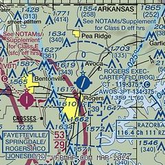
| Sectional chart |
|---|
|
CAUTION: Diagram may not be current

| Airport distance calculator |
|---|
|
|
| Sunrise and sunset |
|---|
|
Times for 12-Dec-2025
| | Local
(UTC-6) | | Zulu
(UTC) |
|---|
| Morning civil twilight | | 06:51 | | 12:51 |
| Sunrise | | 07:20 | | 13:20 |
| Sunset | | 17:01 | | 23:01 |
| Evening civil twilight | | 17:29 | | 23:29 |
|
| Current date and time |
|---|
| Zulu (UTC) | 12-Dec-2025 23:19:45 |
|---|
| Local (UTC-6) | 12-Dec-2025 17:19:45 |
|---|
|
| METAR |
|---|
| KROG | 122258Z 35007KT 10SM CLR 07/00 A3011 RMK AO2 SLP198 T00670000
|
KVBT
5nm W | 122256Z AUTO 03007KT 10SM CLR 07/01 A3012 RMK AO2 SLP206 T00670006 $
|
KXNA
11nm SW | 122253Z AUTO 35009KT 10SM CLR 07/M01 A3010 RMK AO2 SLP195 T00721006
|
KASG
12nm S | 122248Z 33008KT 10SM CLR 10/03 A3008
|
|
| TAF |
|---|
| KROG | 121721Z 1218/1318 03010KT P6SM BKN250 FM130000 VRB04KT P6SM SCT250
|
KXNA
11nm SW | 121721Z 1218/1318 03010KT P6SM BKN250 FM130000 VRB04KT P6SM SCT250
|
|
| NOTAMs |
|---|
NOTAMs are issued by the DoD/FAA and will open in a separate window not controlled by AirNav.
|
|


