FAA INFORMATION EFFECTIVE 19 FEBRUARY 2026
Location
| FAA Identifier: | SAR |
| Lat/Long: | 38-08-55.9090N 089-41-54.6140W
38-08.931817N 089-41.910233W
38.1488636,-89.6985039
(estimated) |
| Elevation: | 537.6 ft. / 163.9 m (surveyed) |
| Variation: | 01E (1990) |
| From city: | 2 miles N of SPARTA, IL |
| Time zone: | UTC -6 (UTC -5 during Daylight Saving Time) |
| Zip code: | 62286 |
Airport Operations
| Airport use: | Open to the public |
| Control tower: | no |
| ARTCC: | KANSAS CITY CENTER |
| FSS: | SAINT LOUIS FLIGHT SERVICE STATION |
| NOTAMs facility: | SAR (NOTAM-D service available) |
| Attendance: | MON-FRI 0800-1700, ALL SAT 0800-1500 |
| Wind indicator: | lighted |
| Segmented circle: | yes |
| Lights: | MIRL RY 18/36 & WIND INDICATOR PRESET ON LOW INTST; TO INCR INTST & ACTVT REIL RY 18 & TWY A - CTAF. |
| Beacon: | white-green (lighted land airport)
Operates sunset to sunrise. |
Airport Communications
| CTAF/UNICOM: | 123.075 |
| WX AWOS-3PT: | 118.375 (618-443-3296) |
| SAINT LOUIS APPROACH: | 125.2 |
| SAINT LOUIS DEPARTURE: | 125.2 |
| WX AWOS-3PT at PCD (18 nm SW): | 118.95 (573-543-5390) |
Nearby radio navigation aids
| VOR radial/distance | | VOR name | | Freq | | Var |
|---|
| ENLr233/30.2 | | CENTRALIA VORTAC | | 115.00 | | 04E |
| TOYr160/36.9 | | TROY VORTAC | | 116.00 | | 04E |
| FAMr041/38.2 | | FARMINGTON VORTAC | | 115.70 | | 01E |
Airport Services
| Fuel available: | 100LL JET-A
100LL:SELF SVC FUEL AVBL 24 HRS WITH CREDIT CARD. |
| Parking: | hangars and tiedowns |
| Airframe service: | MAJOR |
| Powerplant service: | MAJOR |
| Bottled oxygen: | NONE |
| Bulk oxygen: | NONE |
Runway Information
Runway 18/36
| Dimensions: | 4002 x 75 ft. / 1220 x 23 m |
| Surface: | asphalt, in good condition |
| Weight bearing capacity: | |
| Runway edge lights: | medium intensity |
| Runway edge markings: | RWY 36 MARKINGS FADED. |
| RUNWAY 18 | | RUNWAY 36 |
| Latitude: | 38-09.323905N | | 38-08.664617N |
| Longitude: | 089-41.966803W | | 089-41.970300W |
| Elevation: | 537.6 ft. | | 522.8 ft. |
| Traffic pattern: | left | | left |
| Runway heading: | 179 magnetic, 180 true | | 359 magnetic, 000 true |
| Markings: | nonprecision, in poor condition | | nonprecision, in poor condition |
| Visual slope indicator: | 4-light PAPI on left (3.00 degrees glide path)
RY 18 PAPI, UNUSBL BYD 7 DEG LEFT OF COURSE. | | 4-light PAPI on left (3.50 degrees glide path) |
| Runway end identifier lights: | yes | | no |
| Touchdown point: | yes, no lights | | yes, no lights |
Runway 9/27
| Dimensions: | 2958 x 110 ft. / 902 x 34 m |
| Surface: | turf, in good condition |
| Runway edge markings: | & 27 MARKED WITH WHITE CONES. |
| RUNWAY 9 | | RUNWAY 27 |
| Latitude: | 38-08.851667N | | 38-08.843000N |
| Longitude: | 089-42.139833W | | 089-41.522833W |
| Elevation: | 532.5 ft. | | 519.5 ft. |
| Traffic pattern: | left | | left |
| Runway heading: | 090 magnetic, 091 true | | 270 magnetic, 271 true |
| Runway end identifier lights: | no | | no |
| Touchdown point: | yes, no lights | | yes, no lights |
| Obstructions: | none | | 45 ft. tree, 905 ft. from runway, 87 ft. left of centerline, 20:1 slope to clear |
Airport Ownership and Management from official FAA records
| Ownership: | Publicly-owned |
| Owner: | SPARTA COMM ARPT AUTHORITY
1800 N. MARKET
SPARTA, IL 62286
Phone 618-443-2002 |
| Manager: | SCOTT MARQUARDT
1800 N. MARKET
SPARTA, IL 62286
Phone (618) 443-5321 |
Additional Remarks
| - | MIGRATORY WATERFOWL NW OF RY 18/36. |
| - | FOR CD CTC ST LOUIS APCH AT 314-890-1017. |
Instrument Procedures
NOTE: All procedures below are presented as PDF files. If you need a reader for these files, you should download the free Adobe Reader.NOT FOR NAVIGATION. Please procure official charts for flight.
FAA instrument procedures published for use from 19 February 2026 at 0901Z to 19 March 2026 at 0900Z.
IAPs - Instrument Approach Procedures |
|---|
| RNAV (GPS) RWY 18 | |
download (250KB) |
| RNAV (GPS) RWY 36 | |
download (255KB) |
| NOTE: Special Alternate Minimums apply | |
download (149KB) |
| NOTE: Special Take-Off Minimums/Departure Procedures apply | |
download (518KB) |
Other nearby airports with instrument procedures:
KPCD - Perryville Regional Airport (18 nm SW)
KPJY - Pinckneyville/Du Quoin Airport (19 nm SE)
KBLV - Scott Air Force Base/MidAmerica Airport (25 nm N)
KMDH - Southern Illinois Airport (31 nm SE)
KCPS - St Louis Downtown Airport (33 nm NW)
|
|

Road maps at:
MapQuest
Bing
Google
| Aerial photo |
|---|
WARNING: Photo may not be current or correct
 Photo by Bob Srenco
Photo taken 01-Mar-2012
looking northwest.
Photo by Bob Srenco
Photo taken 01-Mar-2012
looking northwest.
Do you have a better or more recent aerial photo of Sparta Community Airport-Hunter Field that you would like to share? If so, please send us your photo.
|
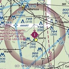
| Sectional chart |
|---|
|
| Airport distance calculator |
|---|
|
|
| Sunrise and sunset |
|---|
|
Times for 15-Mar-2026
| | Local
(UTC-5) | | Zulu
(UTC) |
|---|
| Morning civil twilight | | 06:45 | | 11:45 |
| Sunrise | | 07:11 | | 12:11 |
| Sunset | | 19:05 | | 00:05 |
| Evening civil twilight | | 19:31 | | 00:31 |
|
| Current date and time |
|---|
| Zulu (UTC) | 15-Mar-2026 11:30:35 |
|---|
| Local (UTC-5) | 15-Mar-2026 06:30:35 |
|---|
|
| METAR |
|---|
| KSAR | 151115Z AUTO 18017G25KT 10SM CLR 16/10 A2959 RMK AO2 T01560095
|
KPCD
19nm SW | 151115Z AUTO 19016G26KT 10SM CLR 16/11 A2958 RMK AO2 LTG DSNT N T01600106
|
|
| TAF |
|---|
KBLV
24nm N | 150800Z 1508/1614 17010G15KT 9999 FEW015 SCT130 BKN170 WS020/19050KT QNH2951INS BECMG 1512/1513 17025G35KT 9999 BKN015 OVC025 520003 QNH2937INS TEMPO 1514/1520 19035G44KT 6000 -SHRA 530003 BECMG 1519/1520 19025G35KT 8000 -SHRA BKN015 OVC025 530003 QNH2935INS TEMPO 1520/1524 19035G44KT 6000 -TSRA BKN015CB BECMG 1523/1524 29025G39KT 9999 NSW BKN025 OVC040 620259 530003 QNH2948INS TEMPO 1604/1606 6000 -SN BKN015 650159 BECMG 1606/1607 29025G35KT 9999 BKN025 OVC040 620259 530003 QNH2974INS BECMG 161
|
|
| NOTAMs |
|---|
NOTAMs are issued by the DoD/FAA and will open in a separate window not controlled by AirNav.
|
|

