FAA INFORMATION EFFECTIVE 12 JUNE 2025
Location
| FAA Identifier: | SGR |
| Lat/Long: | 29-37-20.0950N 095-39-23.5230W
29-37.334917N 095-39.392050W
29.6222486,-95.6565342
(estimated) |
| Elevation: | 81.1 ft. / 24.7 m (surveyed) |
| Variation: | 05E (2000) |
| From city: | 17 miles SW of HOUSTON, TX |
| Time zone: | UTC -5 (UTC -6 during Standard Time) |
| Zip code: | 77478 |
Airport Operations
| Airport use: | Open to the public |
| Control tower: | yes |
| ARTCC: | HOUSTON CENTER |
| FSS: | MONTGOMERY COUNTY FLIGHT SERVICE STATION |
| NOTAMs facility: | SGR (NOTAM-D service available) |
| Attendance: | 0500-2300 |
| Wind indicator: | lighted |
| Segmented circle: | yes |
| Lights: | WHEN ATCT CLSD ACTVT REIL RWY 17 & 35; HIRL RWY 17/35 - CTAF. |
| Beacon: | white-green (lighted land airport)
Operates sunset to sunrise. |
| Landing fee: | yes, RAMP FEE FOR CIVIL ACFT; WAIVED WITH FUEL PURCHASE. |
| International operations: | US CUSTOMS USER FEE ARPT. |
Airport Communications
| CTAF: | 118.65 |
| UNICOM: | 122.95 |
| ATIS: | 118.125 |
| WX ASOS: | 118.125 (281-242-7605) |
| SUGAR LAND GROUND: | 121.4 [0600-2200] |
| SUGAR LAND TOWER: | 118.65 [0600-2200] |
| HOUSTON APPROACH: | 123.8 123.8 |
| HOUSTON DEPARTURE: | 123.8 123.8 |
| CLEARANCE DELIVERY: | 119.25 ;WHEN TWR CLSD 121.4 |
| ALEXANDRIA DP: | 123.8 |
| BLTWY RNAV DP: | 123.8 |
| BLUBELL STAR: | 124.225 |
| BORRN RNAV DP: | 123.8 |
| CESAN STAR: | 121.3 |
| CRIED DP: | 123.8 |
| DREMR DP: | 123.8 |
| EL DORADO DP: | 123.8 |
| GIFFA DP: | 123.8 |
| HOODO RNAV DP: | 123.8 |
| HUDZY STAR: | 120.05 |
| INDIE RNAV DP: | 123.8 |
| KARRR RNAV DP: | 123.8 |
| LEONA DP: | 123.8 |
| LUFKIN DP: | 123.8 |
| LURIC DP: | 123.8 |
| MMALT RNAV DP: | 123.8 |
| OHIIO STAR: | 120.05 |
| PALACIOS DP: | 123.8 |
| SNDAY RNAV STAR: | 124.225 |
| STRYA DP: | 123.8 |
| STYCK DP: | 123.8 |
| TKNIQ STAR: | 119.625 |
| TRUAX DP: | 123.8 |
| TSHIRT STAR: | 119.175 |
| TSHRT STAR: | 119.175 |
| WAPPL STAR: | 120.05 |
| WATFO DP: | 123.8 |
| WYLSN RNAV DP: | 123.8 |
| WX AWOS-3 at AXH (12 nm SE): | 123.625 (281-431-6572) |
| WX AWOS-3 at TME (17 nm NW): | 119.525 (281-945-5451) |
| WX ASOS at HOU (20 nm E): | PHONE 713-847-1462 |
Nearby radio navigation aids
| VOR radial/distance | | VOR name | | Freq | | Var |
|---|
| IAHr214/25.8 | | HUMBLE VORTAC | | 116.60 | | 05E |
Airport Services
| Fuel available: | 100LL JET-A+
100LL:100LL AVBL 24 HRS SELF SERVE. FOR JET A+ AFT HRS CALL 281-275-2400 DURG ATNDD HRS. |
| Parking: | hangars and tiedowns |
| Airframe service: | MAJOR |
| Powerplant service: | MAJOR |
| Bottled oxygen: | NONE |
| Bulk oxygen: | HIGH/LOW
NITROGEN AVBL DURG BUSINESS HRS. |
Runway Information
Runway 17/35
| Dimensions: | 8000 x 100 ft. / 2438 x 30 m |
| Surface: | concrete, in excellent condition
RWY NOT GRVD. |
| Weight bearing capacity: | | Single wheel: | 80.0 | | Double wheel: | 120.0 | | Double tandem: | 200.0 | | Dual double tandem: | 600.0 |
|
| Runway edge lights: | high intensity |
| RUNWAY 17 | | RUNWAY 35 |
| Latitude: | 29-37.992647N | | 29-36.677200N |
| Longitude: | 095-39.454148W | | 095-39.329980W |
| Elevation: | 81.1 ft. | | 73.6 ft. |
| Traffic pattern: | left | | left |
| Runway heading: | 170 magnetic, 175 true | | 350 magnetic, 355 true |
| Displaced threshold: | 380 ft. | | 1984 ft. |
| Markings: | precision, in good condition | | precision, in good condition |
| Visual slope indicator: | 2-light PAPI on right (3.50 degrees glide path) | | 4-light PAPI on left (3.00 degrees glide path) |
| Runway end identifier lights: | yes | | yes |
| Touchdown point: | yes, no lights | | yes, no lights |
| Instrument approach: | | | ILS/DME |
| Obstructions: | 55 ft. trees, 280 ft. from runway, 520 ft. right of centerline, 1:1 slope to clear
10 FT RD 0-57 FT FM THR, 50 FT TREES, 0-100 FT DSTC, 488 FT L. | | 30 ft. pline, 201 ft. from runway, 200 ft. left of centerline
+27 FT RR 90 FT FM THR ON CNTRLN; +17 FT RD, +30 FT PWRLINE. |
Airport Ownership and Management from official FAA records
| Ownership: | Publicly-owned |
| Owner: | CITY OF SUGAR LAND
PO BOX 110
SUGAR LAND, TX 77487-0110
Phone 281-275-2100 |
| Manager: | ELIZABETH V. ROSENBAUM
12888 B HWY 6 SOUTH
SUGAR LAND, TX 77498
Phone 281-275-2100 |
Additional Remarks
| - | NO TGLS AFT TWR CLOSES. |
| - | LRA M-F 0800-12-- & 1300-1700. OTR TIMES BY APPT. |
| - | MIL AND CORPORATE GND TRANSPORTATION PRVDD. |
| - | BIRDS ON & INVOF ARPT. |
| - | NOISE ABATEMENT PROC: NOISE SENSITIVE AREAS - INFO AVBL AT TRML. |
| - | NO INT DEPS FOR MULTI-ENGINE ACFT. |
| - | FOR CD WHEN ATCT IS CLSD CTC HOUSTON APCH AT 281-443-5844 TO CNL IFR AT 281-443-5888. |
| - | SFC CONDS NOT RPRTD FRI 10:00 PM - SUN 10:00 PM. |
Instrument Procedures
NOTE: All procedures below are presented as PDF files. If you need a reader for these files, you should download the free Adobe Reader.NOT FOR NAVIGATION. Please procure official charts for flight.
FAA instrument procedures published for use from 12 June 2025 at 0901Z to 10 July 2025 at 0900z.
STARs - Standard Terminal Arrivals |
|---|
| CESAN FOUR (RNAV) | |
2 pages:
[1] [2] (402KB) |
| HUDZY FIVE **NEW** | |
2 pages:
[1] [2] (279KB) |
| OHIIO FOUR | |
download (264KB) |
| SNDAY ONE (RNAV) | |
download (231KB) |
| TKNIQ THREE (RNAV) | |
2 pages:
[1] [2] (327KB) |
| TSHRT TWO | |
2 pages:
[1] [2] (337KB) |
| WAPPL SEVEN (RNAV) **NEW** | |
2 pages:
[1] [2] (403KB) |
| WAPPL SEVEN (RNAV), CONT.2 **NEW** | |
download (282KB) |
IAPs - Instrument Approach Procedures |
|---|
| ILS OR LOC RWY 35 | |
download (239KB) |
| RNAV (GPS) RWY 17 | |
download (201KB) |
| RNAV (GPS) RWY 35 | |
download (242KB) |
| NOTE: Special Alternate Minimums apply | |
download (148KB) |
Departure Procedures |
|---|
| ALEXANDRIA THREE **CHANGED** | |
2 pages:
[1] [2] (354KB) |
| BLTWY SEVEN (RNAV) | |
download (161KB) |
| BORRN SIX (RNAV) | |
2 pages:
[1] [2] (307KB) |
| CRIED ONE | |
2 pages:
[1] [2] (257KB) |
| EL DORADO ONE | |
2 pages:
[1] [2] (270KB) |
| GIFFA ONE | |
2 pages:
[1] [2] (254KB) |
| HOODO SEVEN (RNAV) | |
download (203KB) |
| INDIE EIGHT (RNAV) | |
download (189KB) |
| KARRR SEVEN (RNAV) | |
2 pages:
[1] [2] (256KB) |
| LEONA FOUR | |
2 pages:
[1] [2] (372KB) |
| LUFKIN THREE | |
2 pages:
[1] [2] (273KB) |
| LURIC EIGHT (RNAV) | |
download (209KB) |
| MMALT SEVEN (RNAV) | |
download (216KB) |
| PALACIOS THREE | |
2 pages:
[1] [2] (326KB) |
| STRYA EIGHT (RNAV) | |
download (200KB) |
| STYCK EIGHT (RNAV) | |
download (186KB) |
| WATFO SIX (RNAV) | |
download (169KB) |
| WYLSN EIGHT (RNAV) | |
download (175KB) |
| NOTE: Special Take-Off Minimums/Departure Procedures apply | |
download (70KB) |
Other nearby airports with instrument procedures:
KAXH - Houston Southwest Airport (12 nm SE)
KIWS - West Houston Airport (12 nm N)
KTME - Houston Executive Airport (17 nm NW)
KHOU - William P Hobby Airport (20 nm E)
KLVJ - Pearland Regional Airport (22 nm E)
|
|

Road maps at:
MapQuest
Bing
Google
| Aerial photo |
|---|
WARNING: Photo may not be current or correct
 Photo taken 25-Nov-2019
looking south.
Photo taken 25-Nov-2019
looking south.
Do you have a better or more recent aerial photo of Sugar Land Regional Airport that you would like to share? If so, please send us your photo.
|
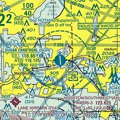
| Sectional chart |
|---|
|
CAUTION: Diagram may not be current
 Download PDF
of official airport diagram from the FAA
| Airport distance calculator |
|---|
|
|
| Sunrise and sunset |
|---|
|
Times for 27-Jun-2025
| | Local
(UTC-5) | | Zulu
(UTC) |
|---|
| Morning civil twilight | | 05:58 | | 10:58 |
| Sunrise | | 06:26 | | 11:26 |
| Sunset | | 20:26 | | 01:26 |
| Evening civil twilight | | 20:53 | | 01:53 |
|
| Current date and time |
|---|
| Zulu (UTC) | 27-Jun-2025 10:24:56 |
|---|
| Local (UTC-5) | 27-Jun-2025 05:24:56 |
|---|
|
| METAR |
|---|
| KSGR | 270953Z AUTO 00000KT 9SM CLR 24/23 A3001 RMK AO2 SLP162 T02390228
|
KAXH
12nm SE | 270955Z AUTO 00000KT 5SM HZ CLR A3001 RMK AO2
|
KHOU
19nm E | 270953Z 15004KT 10SM FEW020 25/23 A3000 RMK AO2 SLP163 T02500233
|
|
| TAF |
|---|
| KSGR | 270520Z 2706/2806 16004KT P6SM FEW025 SCT250 FM271500 14005KT P6SM SCT030 SCT250 FM271800 15007KT P6SM SCT045 BKN250 PROB30 2721/2723 TSRA BKN035CB FM280100 15007KT P6SM FEW030 BKN250
|
KHOU
19nm E | 270520Z 2706/2806 16004KT P6SM FEW025 SCT250 FM271500 14005KT P6SM SCT030 SCT250 FM271800 15008KT P6SM SCT035 BKN250 PROB30 2719/2721 TSRA BKN035CB FM280100 16007KT P6SM FEW030 BKN250
|
|
| NOTAMs |
|---|
NOTAMs are issued by the DoD/FAA and will open in a separate window not controlled by AirNav.
|
|


