FAA INFORMATION EFFECTIVE 20 FEBRUARY 2025
Location
| FAA Identifier: | SLC |
| Lat/Long: | 40-47-18.2160N 111-58-39.9840W
40-47.303600N 111-58.666400W
40.7883933,-111.9777733
(estimated) |
| Elevation: | 4230.9 ft. / 1289.6 m (surveyed) |
| Variation: | 11E (2020) |
| From city: | 3 miles W of SALT LAKE CITY, UT |
| Time zone: | UTC -7 (UTC -6 during Daylight Saving Time) |
| Zip code: | 84116 |
Airport Operations
| Airport use: | Open to the public |
| Activation date: | 11/1938 |
| Control tower: | yes |
| ARTCC: | SALT LAKE CITY CENTER |
| FSS: | CEDAR CITY FLIGHT SERVICE STATION |
| NOTAMs facility: | SLC (NOTAM-D service available) |
| Attendance: | CONTINUOUS |
| Wind indicator: | lighted |
| Segmented circle: | no |
| Lights: | SS-SR |
| Beacon: | white-green (lighted land airport)
Operates sunset to sunrise. |
| Fire and rescue: | ARFF index E |
| International operations: | customs landing rights airport |
Airport Communications
| UNICOM: | 122.95 |
| WX ASOS: | 125.625 (801-359-4103) |
| SALT LAKE CITY GROUND: | 121.9 ;RWY 14/32, 17/35 123.775 ;RWY 16L/34R, 16R/34L 348.6 |
| SALT LAKE CITY TOWER: | 118.3 ;RWY 14/32, 17/35 119.05 ;RWY 16L/34R 132.65 ;RWY 16R/34L 257.8 ;RWY 14/32, 16L/34R, 17/35 336.4 ;RWY 16R/34L |
| SALT LAKE CITY APPROACH: | 120.9 ;SOUTH OF 41 DEG LAT BLW 8000 121.1 ;NORTH OF 41 DEG LAT BLW 8000 124.9 ;300-340 ABV 8000 FT 125.7 126.25 128.1 ;160-250 ABV 8000 FT 128.6 ;110-160 TCH ABV 8,000 FT 135.5 ;340-110 ABV 8000 FT. |
| SALT LAKE CITY DEPARTURE: | 120.9 ;SOUTH OF 41 DEG LAT BLW 8000 121.1 ;NORTH OF 41 DEG LAT BLW 8000 125.7 126.25 126.25 ;250-300 ABV 8000 FT 128.1 ;160-250 ABV 8000 FT 128.6 ;110-160 TCH ABV 8,000 FT 135.5 ;340-110 ABV 8000 FT. |
| CLEARANCE DELIVERY: | 127.3 127.3 379.975 |
| PRE-TAXI CLEARANCE: | 127.3 |
| ANG COMD POST: | 303.15 311.0 |
| ARCHZ DP: | 128.1 |
| BEARR STAR: | 124.9 |
| BONNEVILLE STAR: | 128.6 |
| BRIGHAM CITY STAR: | 124.9 |
| CARTR STAR: | 124.9 |
| CGULL DP: | 135.5 |
| CLASS B: | 120.9 ;SOUTH OF 41 DEG LAT 121.1 ;NORTH OF 41 DEG LAT |
| D-ATIS: | 124.75 125.625 |
| DELTA RNAV STAR: | 128.1 |
| DZERT DP: | 135.5 |
| EMERG: | 121.5 243.0 |
| FAIRFIELD DP: | 128.6 |
| FINAL: | 125.7 |
| IC: | 125.7 |
| JAMMN STAR: | 128.1 |
| JAZZZ STAR: | 128.6 |
| LEEHY RNAV STAR: | 128.6 |
| NORDK RNAV STAR: | 124.9 |
| PITTT STAR: | 128.1 |
| PRE DEP CLNC: | 127.3 |
| QWENN RNAV STAR: | 128.6 |
| RUGGD DP: | 135.5 |
| SALT LAKE DP: | 128.6 |
| SEVYR DP: | 128.1 |
| SKEES RNAV STAR: | 124.9 |
| SPANE STAR: | 128.6 |
| WAATS RNAV STAR: | 128.1 |
| YUTES STAR: | 128.1 |
| ZIONZ RNAV DP: | 128.6 |
| WX AWOS-3 at U42 (10 nm S): | 134.425 (801-562-0271) |
| WX AWOS-3 at TVY (20 nm SW): | 119.725 (435-882-6648) |
- ASDE-X IN USE. OPERATE TRANSPONDERS WITH ALTITUDE REPORTING MODE AND ADS-B (IF EQUIPPED) ENABLED ON ALL AIRPORT SURFACES.
- ANG.
Nearby radio navigation aids
| VOR radial/distance | | VOR name | | Freq | | Var |
|---|
| TCHr161/3.7 | | WASATCH VORTAC | | 116.80 | | 16E |
| OGDr154/26.7 | | OGDEN VORTAC | | 115.70 | | 14E |
| FFUr341/30.9 | | FAIRFIELD VORTAC | | 116.60 | | 16E |
| PVUr326/36.3 | | PROVO VOR/DME | | 108.40 | | 15E |
Airport Services
| Fuel available: | 100LL JET-A1+ |
| Parking: | hangars and tiedowns |
| Airframe service: | MAJOR |
| Powerplant service: | MAJOR |
| Bottled oxygen: | HIGH/LOW |
| Bulk oxygen: | HIGH/LOW |
Runway Information
Runway 16L/34R
| Dimensions: | 12002 x 150 ft. / 3658 x 46 m |
| Surface: | asphalt/grooved, in good condition |
| Weight bearing capacity: | | Single wheel: | 60.0 | | Double wheel: | 200.0 | | Double tandem: | 350.0 | | Dual double tandem: | 850.0 |
|
| Runway edge lights: | high intensity |
| RUNWAY 16L | | RUNWAY 34R |
| Latitude: | 40-48.447163N | | 40-46.478642N |
| Longitude: | 111-58.615928W | | 111-58.387610W |
| Elevation: | 4229.1 ft. | | 4224.3 ft. |
| Traffic pattern: | left | | left |
| Runway heading: | 164 magnetic, 175 true | | 344 magnetic, 355 true |
| Declared distances: | TORA:12002 TODA:12002 ASDA:12002 LDA:12002 | | TORA:12002 TODA:12002 ASDA:12002 LDA:12002 |
| Markings: | precision, in good condition | | precision, in good condition |
| Visual slope indicator: | 4-light PAPI on left (3.00 degrees glide path) | | 4-light PAPI on left (3.00 degrees glide path) |
| RVR equipment: | touchdown, midfield, rollout | | touchdown, midfield, rollout |
| Approach lights: | ALSF2: standard 2,400 foot high intensity approach lighting system with centerline sequenced flashers (category II or III) | | ALSF2: standard 2,400 foot high intensity approach lighting system with centerline sequenced flashers (category II or III) |
| Centerline lights: | yes | | yes |
| Touchdown point: | yes, lighted | | yes, lighted |
| Instrument approach: | ILS/DME | | ILS/DME |
Runway 16R/34L
| Dimensions: | 12000 x 150 ft. / 3658 x 46 m |
| Surface: | concrete/grooved, in good condition |
| Weight bearing capacity: | | Single wheel: | 120.0 | | Double wheel: | 250.0 | | Double tandem: | 550.0 | | Dual double tandem: | 1120.0 |
|
| Runway edge lights: | high intensity |
| RUNWAY 16R | | RUNWAY 34L |
| Latitude: | 40-48.466725N | | 40-46.498618N |
| Longitude: | 111-59.957137W | | 111-59.728188W |
| Elevation: | 4223.4 ft. | | 4228.8 ft. |
| Traffic pattern: | left | | left |
| Runway heading: | 164 magnetic, 175 true | | 344 magnetic, 355 true |
| Declared distances: | TORA:12000 TODA:12000 ASDA:12000 LDA:12000 | | TORA:12000 TODA:12000 ASDA:12000 LDA:12000 |
| Markings: | precision, in good condition | | precision, in good condition |
| Visual slope indicator: | 4-light PAPI on left (3.00 degrees glide path) | | 4-light PAPI on left (3.00 degrees glide path) |
| RVR equipment: | touchdown, midfield, rollout | | touchdown, midfield, rollout |
| Approach lights: | ALSF2: standard 2,400 foot high intensity approach lighting system with centerline sequenced flashers (category II or III) | | ALSF2: standard 2,400 foot high intensity approach lighting system with centerline sequenced flashers (category II or III) |
| Centerline lights: | yes | | yes |
| Touchdown point: | yes, lighted | | yes, lighted |
| Instrument approach: | ILS/DME | | ILS/DME |
Runway 17/35
| Dimensions: | 9596 x 150 ft. / 2925 x 46 m |
| Surface: | asphalt/grooved, in good condition |
| Weight bearing capacity: | | Single wheel: | 60.0 | | Double wheel: | 200.0 | | Double tandem: | 350.0 | | Dual double tandem: | 850.0 |
|
| Runway edge lights: | high intensity |
| RUNWAY 17 | | RUNWAY 35 |
| Latitude: | 40-47.935072N | | 40-46.355037N |
| Longitude: | 111-57.724253W | | 111-57.724160W |
| Elevation: | 4221.7 ft. | | 4226.8 ft. |
| Traffic pattern: | left | | left |
| Runway heading: | 169 magnetic, 180 true | | 349 magnetic, 360 true |
| Displaced threshold: | no | | 324 ft. |
| Declared distances: | TORA:9596 TODA:9596 ASDA:9596 LDA:9596 | | TORA:9596 TODA:9596 ASDA:9596 LDA:9272 |
| Markings: | precision, in good condition | | precision, in good condition |
| Visual slope indicator: | 4-light PAPI on right (3.00 degrees glide path) | | 4-light PAPI on left (3.00 degrees glide path) |
| RVR equipment: | touchdown, rollout | | touchdown, rollout |
| Approach lights: | MALSR: 1,400 foot medium intensity approach lighting system with runway alignment indicator lights | | MALSR: 1,400 foot medium intensity approach lighting system with runway alignment indicator lights |
| Centerline lights: | yes | | yes |
| Touchdown point: | yes, lighted | | yes, lighted |
| Instrument approach: | ILS/DME | | LDA/DME |
| Obstructions: | none | | 24 ft. ant, 1005 ft. from runway, 250 ft. left of centerline, 33:1 slope to clear
HAS 24 FT ANT 1005 FT, 250 FT, 50:1 SLOPE TO DTHR. |
Runway 14/32
| Dimensions: | 4893 x 150 ft. / 1491 x 46 m |
| Surface: | asphalt/grooved, in good condition |
| Weight bearing capacity: | | Single wheel: | 60.0 | | Double wheel: | 200.0 | | Double tandem: | 350.0 | | Dual double tandem: | 850.0 |
|
| Runway edge lights: | high intensity |
| Operational restrictions: | RWY 14/32 CLSD BLW 1200 FT RVR. |
| RUNWAY 14 | | RUNWAY 32 |
| Latitude: | 40-47.143080N | | 40-46.425320N |
| Longitude: | 111-58.274435W | | 111-57.793192W |
| Elevation: | 4224.7 ft. | | 4226.8 ft. |
| Traffic pattern: | left | | left |
| Runway heading: | 142 magnetic, 153 true | | 322 magnetic, 333 true |
| Declared distances: | TORA:4893 TODA:4893 ASDA:4893 LDA:4893 | | TORA:4893 TODA:4893 ASDA:4893 LDA:4893 |
| Markings: | basic, in good condition | | basic, in good condition |
| Visual slope indicator: | 4-light PAPI on left (3.00 degrees glide path) | | 4-light PAPI on left (3.00 degrees glide path) |
| Runway end identifier lights: | no | | no |
| Touchdown point: | yes, no lights | | yes, no lights |
Helipad HB
| Dimensions: | 60 x 60 ft. / 18 x 18 m |
| Surface: | asphalt, in good condition |
| Runway edge lights: | PERI |
| Operational restrictions: | LIGHTED POLE 51 FT AGL 383 FT ESE OF HELIPAD B. |
| Latitude: | 40-46.451378N | | |
| Longitude: | 111-57.400937W | | |
| Elevation: | 4220.4 ft. | | |
| Traffic pattern: | left | | left |
| Markings: | basic, in fair condition | | |
Helipad HF
| Dimensions: | 60 x 60 ft. / 18 x 18 m |
| Surface: | asphalt, in good condition |
| Runway edge lights: | PERI |
| Latitude: | 40-46.944667N | | |
| Longitude: | 111-57.563500W | | |
| Elevation: | 4220.0 ft. | | |
| Traffic pattern: | left | | left |
| Markings: | basic, in fair condition | | |
Airport Ownership and Management from official FAA records
| Ownership: | Publicly-owned |
| Owner: | SALT LAKE CITY
CITY AND COUNTY BLDG
SALT LAKE CITY, UT 84101
Phone 801-575-2460 |
| Manager: | MATTHEW BROWN
P.O. BOX 145550
SALT LAKE CITY, UT 84114-5550
Phone 801-575-2244 |
Additional Remarks
| A39-16L/34R | PCR VALUE: 900/F/D/X/U |
| A39-16R/34L | PCR VALUE: 1370/R/D/W/T |
| A39-17/35 | PCR VALUE: 900/F/D/X/U |
| - | SURFACE MOVEMENT GUIDANCE CONTROL SYSTEM & LOW VISIBILITY TAXI PROCEDURES. |
| - | DUE TO TFC VOL, LCL DEPARTURE AND ARR OPNS ARE DISCOURAGED AND DLAS CAN BE EXPCD BTN 1500-1730Z++ AND 0130-0300Z++. |
| - | SVFR IS NOT RCMD AT THE ARPT, IF REQD, EXPT DLAS. |
| - | MILITARY: ANG RAMP: OPR 1430-2230Z++ MON-THU. CLSD FRI-SUN AND HOL. OFFL BUS ONLY. PPR REQ 48 HR ALL ACFT, VALID 1 HR +/- ETA. TRAN PRK/SVC EXTREMELY LTD. BASE OPS DSN 245-2274, C801-245-2274. MIL ALT HILL AFB (KHIF) 25 NM N. ALL ACFT CTC UTAH CTL (COMD POST) 20 MIN OUT WITH ETA AND REQ. |
| - | MILITARY: ANG RAMP: ALL ACFT CTC UTAH CONTROL WITH LDG & DEP TIMES. COMD POST DSN: 245-2416/2417; C801-245-2416/2417. PHASE II WILDLIFE ACT DURING MIGRATION/MORNING/EVENING HRS FR OCT-APR. CTC UTAH CTL FOR CURRENT BIRD-WATCH COND. |
| - | SEE FLIP AP/1 SUPPLEMENTARY ARPT INFO. |
| - | MILITARY: COMMUNICATIONS: ANG COMD POST - CALL UTAH CONTROL. |
| - | USE CAUTION FOR EXTENSIVE PARAGLIDING OPS INVOF POINT OF THE MOUNTAIN. |
| - | SEE CURRENT NOTAMS FOR DATES AND ADDITIONAL INFO. |
| - | FLOCK OF BIRDS ON AND IN VICINITY OF ARPT. |
| - | MILITARY: SVC: FUEL A++. |
| - | TWY G RSTD TO WINGSPANS LESS THAN 171 FT BTWN TWY G2 AND G3. |
| - | USE MINIMUM THRUST IN CONSTRUCTION AREAS. |
| - | CONTACT GROUND ON 123.775 BEFORE TAXIING OUT OF NORTH CARGO. |
| - | MILITARY: ANG RAMP: NSTD PAVEMENT MARK ON RAMP. |
| - | TWY K RSTRD TO ACFT WITH WINGSPAN LESS THAN 171 FT. |
| - | HELIPADS B AND F LOCATED ON GENERAL AVIATION APRONS. |
| - | TWY F BTN TWY F2 & TWY F3 NORTH SIDE SAFETY AREA NOT STD. |
Instrument Procedures
NOTE: All procedures below are presented as PDF files. If you need a reader for these files, you should download the free Adobe Reader.NOT FOR NAVIGATION. Please procure official charts for flight.
FAA instrument procedures published for use from 20 February 2025 at 0901Z to 20 March 2025 at 0900Z.
STARs - Standard Terminal Arrivals |
|---|
| BEARR FIVE | |
2 pages:
[1] [2] (290KB) |
| BONNEVILLE TWO | |
download (117KB) |
| BRIGHAM CITY FIVE | |
2 pages:
[1] [2] (361KB) |
| CARTR ONE (RNAV) **NEW** | |
2 pages:
[1] [2] (406KB) |
| JAMMN FIVE | |
2 pages:
[1] [2] (253KB) |
| JAZZZ ONE (RNAV) **NEW** | |
download (179KB) |
| PITTT ONE (RNAV) **NEW** | |
2 pages:
[1] [2] (358KB) |
| QWENN SIX (RNAV) **NEW** | |
download (170KB) |
| SKEES SIX (RNAV) **NEW** | |
2 pages:
[1] [2] (343KB) |
| SPANE EIGHT | |
download (254KB) |
| YUTES ONE (RNAV) **NEW** | |
download (246KB) |
IAPs - Instrument Approach Procedures |
|---|
| ILS OR LOC RWY 16L **CHANGED** | |
download (667KB) |
| ILS OR LOC RWY 16R **CHANGED** | |
download (662KB) |
| ILS OR LOC RWY 17 **CHANGED** | |
download (687KB) |
| ILS OR LOC RWY 34L **CHANGED** | |
download (893KB) |
| ILS OR LOC RWY 34R **CHANGED** | |
download (881KB) |
| ILS RWY 16R (SA CAT I) **CHANGED** | |
download (643KB) |
| ILS RWY 34L (SA CAT I) **CHANGED** | |
download (866KB) |
| ILS RWY 34R (SA CAT I) **CHANGED** | |
download (854KB) |
| ILS RWY 17 (SA CAT I - II) **CHANGED** | |
download (688KB) |
| ILS RWY 16L (CAT II - III) **CHANGED** | |
download (662KB) |
| ILS RWY 16R (CAT II - III) **CHANGED** | |
download (646KB) |
| ILS RWY 34L (CAT II - III) **CHANGED** | |
download (872KB) |
| ILS RWY 34R (CAT II - III) **CHANGED** | |
download (869KB) |
| RNAV (RNP) Z RWY 16L **NEW** | |
download (615KB) |
| RNAV (RNP) Z RWY 16R **NEW** | |
download (398KB) |
| RNAV (RNP) Z RWY 17 **NEW** | |
download (627KB) |
| RNAV (RNP) Z RWY 34L **NEW** | |
download (821KB) |
| RNAV (RNP) Z RWY 34R **NEW** | |
download (808KB) |
| RNAV (RNP) Z RWY 35 **NEW** | |
download (814KB) |
| RNAV (GPS) Y RWY 16L **NEW** | |
download (649KB) |
| RNAV (GPS) Y RWY 16R **NEW** | |
download (634KB) |
| RNAV (GPS) Y RWY 17 **NEW** | |
download (690KB) |
| RNAV (GPS) Y RWY 34L **NEW** | |
download (843KB) |
| RNAV (GPS) Y RWY 34R **NEW** | |
download (865KB) |
| RNAV (GPS) Y RWY 35 **NEW** | |
download (855KB) |
| LDA RWY 35 **CHANGED** | |
download (886KB) |
Departure Procedures |
|---|
| ARCHZ ONE (RNAV) | |
download (201KB) |
| CGULL ONE (RNAV) | |
download (222KB) |
| DEZRT TWO (RNAV) | |
download (260KB) |
| FAIRFIELD NINE | |
2 pages:
[1] [2] (420KB) |
| RUGGD THREE (RNAV) | |
2 pages:
[1] [2] (392KB) |
| SALT LAKE FOUR | |
2 pages:
[1] [2] (514KB) |
| SEVYR THREE | |
2 pages:
[1] [2] (344KB) |
| ZIONZ ONE (RNAV) | |
download (222KB) |
| NOTE: Special Take-Off Minimums/Departure Procedures apply | |
download (540KB) |
Other nearby airports with instrument procedures:
U42 - South Valley Regional Airport (10 nm S)
KTVY - Bolinder Field/Tooele Valley Airport (20 nm SW)
KHIF - Hill Air Force Base (20 nm N)
KOGD - Ogden-Hinckley Airport (24 nm N)
KHCR - Heber Valley Airport (31 nm SE)
|
|

Road maps at:
MapQuest
Bing
Google
| Aerial photo |
|---|
WARNING: Photo may not be current or correct
 Photo courtesy of Mitch Bowers Imagewerx.us Aerial Photography
Photo taken 24-Apr-2013
from 11,500' looking north.
Photo courtesy of Mitch Bowers Imagewerx.us Aerial Photography
Photo taken 24-Apr-2013
from 11,500' looking north.
Do you have a better or more recent aerial photo of Salt Lake City International Airport that you would like to share? If so, please send us your photo.
|
| Sectional chart |
|---|
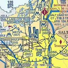
|
CAUTION: Diagram may not be current
 Download PDF
of official airport diagram from the FAA
| Airport distance calculator |
|---|
|
|
| Sunrise and sunset |
|---|
|
Times for 11-Mar-2025
| | Local
(UTC-7) | | Zulu
(UTC) |
|---|
| Morning civil twilight | | 06:20 | | 13:20 |
| Sunrise | | 06:47 | | 13:47 |
| Sunset | | 18:29 | | 01:29 |
| Evening civil twilight | | 18:56 | | 01:56 |
|
| Current date and time |
|---|
| Zulu (UTC) | 11-Mar-2025 09:51:48 |
|---|
| Local (UTC-7) | 11-Mar-2025 02:51:48 |
|---|
|
| METAR |
|---|
| KSLC | 110854Z 00000KT 10SM FEW220 BKN250 04/M03 A2983
|
KU42
10nm S | 110935Z AUTO 22005KT 10SM CLR 06/M08 A2985 RMK AO2
|
KHIF
20nm N | 110855Z AUTO 11011KT 10SM CLR 05/M06 A2986 RMK AO2 SLP089 T00511056 58003 $
|
KTVY
20nm SW | 110935Z AUTO 17011KT 10SM CLR 03/M04 A2985 RMK AO2
|
|
| TAF |
|---|
| KSLC | 110533Z 1106/1212 15007KT P6SM SCT250 FM111700 17014G24KT P6SM SCT150 SCT200 FM120200 16010KT P6SM SCT150
|
KHIF
20nm N | 110500Z 1105/1211 09012KT 9999 SCT180 QNH2982INS BECMG 1116/1117 18012G18KT 9999 SCT200 QNH2975INS BECMG 1202/1203 09012KT 9999 FEW070 SCT120 QNH2974INS TX15/1121Z TN03/1111Z
|
|
| NOTAMs |
|---|
NOTAMs are issued by the DoD/FAA and will open in a separate window not controlled by AirNav.
|
|


