FAA INFORMATION EFFECTIVE 27 NOVEMBER 2025
Location
| FAA Identifier: | T30 |
| Lat/Long: | 28-49-20.1000N 099-06-32.5000W
28-49.335000N 099-06.541667W
28.8222500,-99.1090278
(estimated) |
| Elevation: | 586.4 ft. / 178.7 m (surveyed) |
| Variation: | 07E (1980) |
| From city: | 4 miles S of PEARSALL, TX |
| Time zone: | UTC -6 (UTC -5 during Daylight Saving Time) |
| Zip code: | 78061 |
Airport Operations
| Airport use: | Open to the public |
| Activation date: | 09/1955 |
| Control tower: | no |
| ARTCC: | HOUSTON CENTER |
| FSS: | SAN ANGELO FLIGHT SERVICE STATION |
| NOTAMs facility: | SJT (NOTAM-D service available) |
| Attendance: | CONTINUOUS |
| Wind indicator: | lighted |
| Segmented circle: | yes |
| Lights: | SS-SR |
| Landing fee: | yes |
Airport Communications
- APCH/DEP CTL SVC PRVDD BY HOUSTON ARTCC (ZHU) ON FREQS 134.6/322.5 (THREE RIVERS RCAG).
Nearby radio navigation aids
| VOR radial/distance | | VOR name | | Freq | | Var |
|---|
| COTr352/21.6 | | COTULLA VORTAC | | 115.80 | | 09E |
| NDB name | | Hdg/Dist | | Freq | | Var | | ID |
|---|
| DEVINE | | 198/21.0 | | 359 | | 07E | | HHH | .... .... .... |
| LA PRYOR | | 090/39.7 | | 223 | | 09E | | LKX | .-.. -.- -..- |
Airport Services
| Fuel available: | A |
| Parking: | tiedowns |
| Airframe service: | NONE |
| Powerplant service: | NONE |
| Bottled oxygen: | NONE |
| Bulk oxygen: | NONE |
Runway Information
Runway 13/31
| Dimensions: | 5027 x 60 ft. / 1532 x 18 m |
| Surface: | asphalt, in good condition |
| Weight bearing capacity: | | Single wheel: | 15.0, ESTD. |
|
| Runway edge lights: | low intensity
NSTD LIRL; SPACING 20 FT FM EDGE & 300 FT BTN LGTS. |
| Runway edge markings: | MKGS FADED. |
| RUNWAY 13 | | RUNWAY 31 |
| Latitude: | 28-49.639250N | | 28-49.030833N |
| Longitude: | 099-06.861867W | | 099-06.221767W |
| Elevation: | 586.4 ft. | | 553.8 ft. |
| Traffic pattern: | left | | left |
| Runway heading: | 130 magnetic, 137 true | | 310 magnetic, 317 true |
| Displaced threshold: | 168 ft. | | 154 ft. |
| Markings: | basic, in poor condition | | basic, in poor condition |
| Touchdown point: | yes, no lights | | yes, no lights |
| Obstructions: | 15 ft. road, 201 ft. from runway, 76 ft. right of centerline
APCH RATIO 22:1 TO DSPLCD THR; 15 FT ROAD 330 FT FM DSPLCD THR 130 FT RIGHT. | | 60 ft. pline, 2120 ft. from runway, 32:1 slope to clear
RWY 31 APCH RATIO 37:1 TO DSPLCD THR. |
Airport Ownership and Management from official FAA records
| Ownership: | Privately-owned |
| Owner: | AERIAL LLC
BOX 764
PEARSALL, TX 78061
Phone 830-334-7306 |
| Manager: | IKE & NATHAN MC KINLEY
170 ENCINO
PEARSALL, TX 78061
Phone 830-334-7306
ALT MGR NUMBER NATHAN MC KINLEY 210-542-0093 |
Additional Remarks
| - | FOR CD CTC HOUSTON ARTCC AT 281-230-5622. |
| - | DSPLCD THRS NOT LGTD, 4705 FT AVBL NGT. |
Instrument Procedures
NOTE: All procedures below are presented as PDF files. If you need a reader for these files, you should download the free Adobe Reader.NOT FOR NAVIGATION. Please procure official charts for flight.
FAA instrument procedures published for use from 27 November 2025 at 0901Z to 25 December 2025 at 0900Z.
IAPs - Instrument Approach Procedures |
|---|
| VOR/DME OR GPS-A | |
download (149KB) |
| NOTE: Special Take-Off Minimums/Departure Procedures apply | |
download (294KB) |
Other nearby airports with instrument procedures:
23R - Devine Municipal Airport (21 nm NE)
KCOT - Cotulla-La Salle County Airport (23 nm S)
KPEZ - Pleasanton Municipal Airport (32 nm E)
KHDO - South Texas Regional Airport at Hondo (32 nm N)
KCVB - Castroville Municipal Airport (34 nm NE)
|
|

Road maps at:
MapQuest
Bing
Google
| Aerial photo |
|---|
WARNING: Photo may not be current or correct
 Photo by Murray McKinley
Photo taken 23-Apr-2010
looking southeast.
Photo by Murray McKinley
Photo taken 23-Apr-2010
looking southeast.
Do you have a better or more recent aerial photo of Mc Kinley Field Airport that you would like to share? If so, please send us your photo.
|
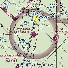
| Sectional chart |
|---|
|
| Airport distance calculator |
|---|
|
|
| Sunrise and sunset |
|---|
|
Times for 21-Dec-2025
| | Local
(UTC-6) | | Zulu
(UTC) |
|---|
| Morning civil twilight | | 07:00 | | 13:00 |
| Sunrise | | 07:26 | | 13:26 |
| Sunset | | 17:43 | | 23:43 |
| Evening civil twilight | | 18:09 | | 00:09 |
|
| Current date and time |
|---|
| Zulu (UTC) | 21-Dec-2025 18:43:37 |
|---|
| Local (UTC-6) | 21-Dec-2025 12:43:37 |
|---|
|
| METAR |
|---|
KCOT
23nm S | 211753Z AUTO 03006KT 6SM BR OVC005 18/17 A3016 RMK AO2 SLP207 T01780172 10178 20133 50013 $
|
KPEZ
32nm E | 211815Z AUTO 10SM OVC010 18/11 A3019 RMK AO2 T01790110
|
KHDO
33nm N | 211751Z AUTO 03007KT 10SM CLR 21/06 A3018 RMK AO2 SLP210 T02110056 10211 20083 50013 $
|
KCVB
34nm NE | 211815Z AUTO 10004KT 10SM CLR 23/08 A3016 RMK AO2
|
KUVA
41nm NW | 211815Z AUTO 00000KT CLR 23/07 A3019 RMK AO2 T02260066 PWINO
|
KCZT
42nm SW | 119.625
211815Z AUTO 09004KT 10SM CLR 22/16 A3017 RMK AO2
|
KSKF
43nm NE | 211755Z AUTO 06005KT 10SM CLR 21/04 A3013 RMK AO2 SLP200 T02060042 10206 20119 50011 $
|
KSSF
46nm NE | 211753Z 06006KT 10SM CLR 21/06 A3015 RMK AO2 SLP207 T02060056 10206 20122 50010 $
|
|
| TAF |
|---|
KCOT
23nm S | 211730Z 2118/2218 06005KT 2SM BR OVC005 FM211900 05005KT 6SM BR OVC015 FM212100 VRB05KT P6SM BKN050 FM220800 06005KT 4SM BR BKN015 TEMPO 2211/2215 1/2SM FG OVC003
|
|
| NOTAMs |
|---|
NOTAMs are issued by the DoD/FAA and will open in a separate window not controlled by AirNav.
|
|

