FAA INFORMATION EFFECTIVE 14 MAY 2026
Location
| FAA Identifier: | TXK |
| Lat/Long: | 33-27-13.3790N 093-59-27.7100W
33-27.222983N 093-59.461833W
33.4537164,-93.9910306
(estimated) |
| Elevation: | 389.7 ft. / 118.8 m (surveyed) |
| Variation: | 05E (1985) |
| From city: | 3 miles NE of TEXARKANA, AR |
| Time zone: | UTC -5 (UTC -6 during Standard Time) |
| Zip code: | 71854 |
Airport Operations
| Airport use: | Open to the public |
| Activation date: | 04/1940 |
| Control tower: | yes |
| ARTCC: | FORT WORTH CENTER |
| FSS: | JONESBORO FLIGHT SERVICE STATION |
| NOTAMs facility: | TXK (NOTAM-D service available) |
| Attendance: | 0600-2200 |
| Pattern altitude: | 1589.7 ft. MSL |
| Wind indicator: | lighted |
| Segmented circle: | yes |
| Lights: | WHEN ATCT CLSD ACTVT MALSR RWY 22; HIRL RWY 04/22; MIRL RWY 13/31 - CTAF. |
| Beacon: | white-green (lighted land airport)
Operates sunset to sunrise. |
| Landing fee: | yes |
| Fire and rescue: | ARFF index A |
Airport Communications
| CTAF: | 123.875 |
| ATIS: | 120.2 |
| WX ASOS: | 120.2 (870-774-0404) |
| TEXARKANA GROUND: | 119.225 [0600-2200] |
| TEXARKANA TOWER: | 123.875 235.625 [0600-2200] |
| EMERG: | 121.5 243.0 |
- APCH/DEP CTL SVC PRVDD BY FORT WORTH ARTCC (ZFW) ON FREQS 123.925/269.475 (TEXARKANA RCAG).
- ATCT OPERATED BY ROBERTSON VAN BUREN ASSOCIATE INC.
Nearby radio navigation aids
| VOR radial/distance | | VOR name | | Freq | | Var |
|---|
| TXKr124/5.5 | | TEXARKANA VORTAC | | 116.30 | | 07E |
| NDB name | | Hdg/Dist | | Freq | | Var | | ID |
|---|
| TECCO | | 220/6.0 | | 234 | | 05E | | TX | - -..- |
| ATLANTA | | 021/23.2 | | 347 | | 04E | | ATA | .- - .- |
| HOPE | | 224/23.3 | | 362 | | 03E | | HPC | .... .--. -.-. |
Airport Services
| Fuel available: | 100LL JET-A |
| Parking: | hangars and tiedowns |
| Airframe service: | MAJOR |
| Powerplant service: | MAJOR |
| Bottled oxygen: | HIGH |
Runway Information
Runway 4/22
| Dimensions: | 6602 x 150 ft. / 2012 x 46 m |
| Surface: | asphalt/grooved, in good condition |
| Weight bearing capacity: | | Single wheel: | 50.0 | | Double wheel: | 86.0 | | Double tandem: | 120.0 |
|
| Runway edge lights: | high intensity |
| RUNWAY 4 | | RUNWAY 22 |
| Latitude: | 33-26.775117N | | 33-27.545143N |
| Longitude: | 094-00.081355W | | 093-59.163618W |
| Elevation: | 338.4 ft. | | 384.3 ft. |
| Traffic pattern: | left | | left |
| Runway heading: | 040 magnetic, 045 true | | 220 magnetic, 225 true |
| Declared distances: | TORA:6602 TODA:6602 ASDA:6602 LDA:6602 | | TORA:6602 TODA:6602 ASDA:6602 LDA:6602 |
| Markings: | precision, in good condition | | precision, in good condition |
| Visual slope indicator: | 4-box VASI on left (3.00 degrees glide path) | | |
| Approach lights: | | | MALSR: 1,400 foot medium intensity approach lighting system with runway alignment indicator lights |
| Touchdown point: | yes, no lights | | yes, no lights |
| Instrument approach: | | | ILS/DME |
| Obstructions: | 31 ft. trees, 263 ft. from runway, 505 ft. left of centerline, 2:1 slope to clear | | 17 ft. trees, 358 ft. from runway, 511 ft. left of centerline, 9:1 slope to clear |
Runway 13/31
| Dimensions: | 5200 x 100 ft. / 1585 x 30 m |
| Surface: | asphalt/grooved, in good condition |
| Weight bearing capacity: | |
| Runway edge lights: | medium intensity |
| RUNWAY 13 | | RUNWAY 31 |
| Latitude: | 33-27.605792N | | 33-26.999680N |
| Longitude: | 093-59.619488W | | 093-58.896155W |
| Elevation: | 360.7 ft. | | 385.6 ft. |
| Traffic pattern: | left | | left |
| Runway heading: | 130 magnetic, 135 true | | 310 magnetic, 315 true |
| Displaced threshold: | 641 ft. | | no |
| Declared distances: | TORA:5200 TODA:5200 ASDA:5200 LDA:4559 | | TORA:5200 TODA:5200 ASDA:4559 LDA:4559 |
| Markings: | nonprecision, in good condition | | nonprecision, in good condition |
| Visual slope indicator: | 4-light PAPI on left (3.00 degrees glide path) | | |
| Touchdown point: | yes, no lights | | yes, no lights |
| Obstructions: | 15 ft. rr, 350 ft. from runway, 22:1 slope to clear | | 40 ft. tree, 750 ft. from runway, 300 ft. left of centerline, 20:1 slope to clear |
Airport Ownership and Management from official FAA records
| Ownership: | Publicly-owned |
| Owner: | TEXARKANA AIRPORT AUTHORITY
201 AIRPORT DR
TEXARKANA, AR 71854
Phone 870-774-2171
TEXARKANA AIRPORT AUTHORITY |
| Manager: | FERDINAND PAUL MEHRLICH III, ACE
201 AIRPORT DR
TEXARKANA, AR 71854
Phone 870-774-2171 |
Additional Remarks
| A39-13/31 | PCR VALUE: 180/F/C/Y/U |
| A39-04/22 | PCR VALUE: 459/F/B/X/T |
| - | DEER ON & INVOF ARPT. |
| - | FOR CD IF UNA TO CTC ON FSS FREQ, CTC FORT WORTH ARTCC AT 817-858-7584. |
| - | BIRDS ON & INVOF ARPT. |
Instrument Procedures
NOTE: All procedures below are presented as PDF files. If you need a reader for these files, you should download the free Adobe Reader.NOT FOR NAVIGATION. Please procure official charts for flight.
FAA instrument procedures published for use from 14 May 2026 at 0901Z to 11 June 2026 at 0900Z.
IAPs - Instrument Approach Procedures |
|---|
| ILS OR LOC RWY 22 | |
download (257KB) |
| RNAV (GPS) RWY 04 | |
download (263KB) |
| RNAV (GPS) RWY 13 | |
download (274KB) |
| RNAV (GPS) RWY 22 | |
download (267KB) |
| RNAV (GPS) RWY 31 | |
download (259KB) |
| VOR RWY 13 | |
download (249KB) |
| NOTE: Special Alternate Minimums apply | |
download (144KB) |
| NOTE: Special Take-Off Minimums/Departure Procedures apply | |
download (390KB) |
Other nearby airports with instrument procedures:
M18 - Hope Municipal Airport (23 nm NE)
KATA - Hall-Miller Municipal Airport (23 nm SW)
M77 - Howard County Airport (33 nm N)
3F4 - Vivian Airport (36 nm S)
KSPH - Springhill Airport (41 nm SE)
|
|

Road maps at:
MapQuest
Bing
Google
| Aerial photo |
|---|
WARNING: Photo may not be current or correct
 Photo courtesy of the Arkansas Department of Aeronautics
Taken in the Spring of 2007
Photo courtesy of the Arkansas Department of Aeronautics
Taken in the Spring of 2007
Do you have a better or more recent aerial photo of Texarkana Regional Airport-Webb Field that you would like to share? If so, please send us your photo.
|
| Sectional chart |
|---|
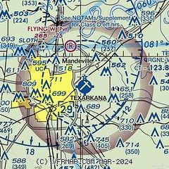
|
 Download PDF
of official airport diagram from the FAA
| Airport distance calculator |
|---|
|
|
| Sunrise and sunset |
|---|
|
Times for 15-May-2026
| | Local
(UTC-5) | | Zulu
(UTC) |
|---|
| Morning civil twilight | | 05:49 | | 10:49 |
| Sunrise | | 06:17 | | 11:17 |
| Sunset | | 20:08 | | 01:08 |
| Evening civil twilight | | 20:35 | | 01:35 |
|
| Current date and time |
|---|
| Zulu (UTC) | 15-May-2026 21:59:54 |
|---|
| Local (UTC-5) | 15-May-2026 16:59:54 |
|---|
|
| METAR |
|---|
| KTXK | 152153Z 18011G20KT 10SM CLR 32/18 A2987 RMK AO2 SLP109 T03220178
|
|
| TAF |
|---|
| KTXK | 151740Z 1518/1618 18010KT P6SM SKC FM160000 17010KT P6SM BKN180 BKN250 FM161500 20010G20KT P6SM SCT150 BKN180 BKN250
|
|
| NOTAMs |
|---|
NOTAMs are issued by the DoD/FAA and will open in a separate window not controlled by AirNav.
|
|


