FAA INFORMATION EFFECTIVE 04 SEPTEMBER 2025
Location
| FAA Identifier: | 3F4 |
| Lat/Long: | 32-51-40.8000N 094-00-36.5530W
32-51.680000N 094-00.609217W
32.8613333,-94.0101536
(estimated) |
| Elevation: | 260 ft. / 79.2 m (surveyed) |
| Variation: | 02E (2010) |
| From city: | 2 miles SW of VIVIAN, LA |
| Time zone: | UTC -5 (UTC -6 during Standard Time) |
| Zip code: | 71082 |
Airport Operations
| Airport use: | Open to the public |
| Activation date: | 02/1960 |
| Control tower: | no |
| ARTCC: | FORT WORTH CENTER |
| FSS: | DE RIDDER FLIGHT SERVICE STATION |
| NOTAMs facility: | DRI (NOTAM-D service available) |
| Attendance: | MON-SAT DAWN-DUSK |
| Wind indicator: | lighted |
| Segmented circle: | no |
| Lights: | MIRL RY 09/27 AND REIL RY 09 PRESET LOW INTST DUSK-DAWN; TO INCR INTST ACTVT - CTAF. |
| Beacon: | white-green (lighted land airport)
Operates sunset to sunrise. |
Airport Communications
| CTAF/UNICOM: | 122.8 |
| SHREVEPORT APPROACH: | 119.9 |
| SHREVEPORT DEPARTURE: | 119.9 |
| WX AWOS-3 at ATA (17 nm NW): | 118.250 (903-799-4066) |
Nearby radio navigation aids
| VOR radial/distance | | VOR name | | Freq | | Var |
|---|
| EICr291/11.4 | | BELCHER VORTAC | | 117.40 | | 07E |
| EMGr316/34.7 | | ELM GROVE VORTAC | | 116.65 | | 07E |
| TXKr168/39.3 | | TEXARKANA VORTAC | | 116.30 | | 07E |
| NDB name | | Hdg/Dist | | Freq | | Var | | ID |
|---|
| ATLANTA | | 144/17.2 | | 347 | | 04E | | ATA | .- - .- |
Airport Services
| Fuel available: | 100LL
100LL:FUEL AVBL 24 HRS SELF SVC WITH CREDIT CARD. |
| Parking: | hangars and tiedowns |
| Airframe service: | MAJOR |
| Powerplant service: | MAJOR |
| Bottled oxygen: | NONE |
| Bulk oxygen: | NONE |
Runway Information
Runway 9/27
| Dimensions: | 2998 x 75 ft. / 914 x 23 m |
| Surface: | asphalt, in good condition |
| Weight bearing capacity: | |
| Runway edge lights: | medium intensity |
| RUNWAY 9 | | RUNWAY 27 |
| Latitude: | 32-51.678283N | | 32-51.681517N |
| Longitude: | 094-00.902067W | | 094-00.316267W |
| Elevation: | 247.0 ft. | | 259.0 ft. |
| Traffic pattern: | left | | left |
| Runway heading: | 088 magnetic, 090 true | | 268 magnetic, 270 true |
| Markings: | nonprecision, in good condition | | nonprecision, in good condition |
| Visual slope indicator: | 2-light PAPI on left (3.00 degrees glide path)
RWY 09 PAPI OTS - PAPIS ARE NOT COMMISSIONED | | 2-light PAPI on left (3.00 degrees glide path)
RWY 27 PAPI OTS - PAPIS ARE NOT COMMISSIONED |
| Runway end identifier lights: | yes | | yes |
| Touchdown point: | yes, no lights | | yes, no lights |
| Obstructions: | 27 ft. trees, 720 ft. from runway, 62 ft. left of centerline, 19:1 slope to clear | | 106 ft. trees, 2392 ft. from runway, 208 ft. right of centerline, 20:1 slope to clear |
Airport Ownership and Management from official FAA records
| Ownership: | Publicly-owned |
| Owner: | TOWN OF VIVIAN
P. O. BOX 832
VIVIAN, LA 71082
Phone 318-375-3856 |
| Manager: | MR. MARTY MUSICK
P. O. BOX 648
VIVIAN, LA 71082
Phone (318) 455-5499 |
Additional Remarks
| - | GCO AVBL ON FREQ 135.075 THRU BAD APCH CTL AND FLT SVCS. |
| - | FOR CD IF UNA VIA GCO CTC FORT WORTH ARTCC AT 817-858-7584. |
| - | CTC ARPT MGR FOR DSNGD RAMP SPACE FOR PUB USE AT THE ARPT |
Instrument Procedures
NOTE: All procedures below are presented as PDF files. If you need a reader for these files, you should download the free Adobe Reader.NOT FOR NAVIGATION. Please procure official charts for flight.
FAA instrument procedures published for use from 04 September 2025 at 0901Z to 02 October 2025 at 0900z.
IAPs - Instrument Approach Procedures |
|---|
| RNAV (GPS) RWY 09 **CHANGED** | |
download (197KB) |
| RNAV (GPS) RWY 27 **CHANGED** | |
download (179KB) |
| VOR/DME-A **CHANGED** | |
download (158KB) |
| NOTE: Special Take-Off Minimums/Departure Procedures apply | |
download (116KB) |
Other nearby airports with instrument procedures:
KATA - Hall-Miller Municipal Airport (17 nm NW)
KDTN - Shreveport Downtown Airport (23 nm SE)
KASL - Harrison County Airport (25 nm SW)
KSHV - Shreveport Regional Airport (27 nm S)
KBAD - Barksdale Air Force Base (28 nm SE)
|
|

Road maps at:
MapQuest
Bing
Google
| Aerial photo |
|---|
WARNING: Photo may not be current or correct
 Photo by Carl Hennigan
Taken in May 2007
Photo by Carl Hennigan
Taken in May 2007
Do you have a better or more recent aerial photo of Vivian Airport that you would like to share? If so, please send us your photo.
|
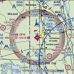
| Sectional chart |
|---|
|
| Airport distance calculator |
|---|
|
|
| Sunrise and sunset |
|---|
|
Times for 28-Sep-2025
| | Local
(UTC-5) | | Zulu
(UTC) |
|---|
| Morning civil twilight | | 06:45 | | 11:45 |
| Sunrise | | 07:09 | | 12:09 |
| Sunset | | 19:04 | | 00:04 |
| Evening civil twilight | | 19:29 | | 00:29 |
|
| Current date and time |
|---|
| Zulu (UTC) | 28-Sep-2025 10:18:33 |
|---|
| Local (UTC-5) | 28-Sep-2025 05:18:33 |
|---|
|
| METAR |
|---|
KDTN
23nm SE | 280953Z AUTO 00000KT 10SM CLR 18/17 A3004 RMK AO2 SLP170 T01830167
|
KASL
25nm SW | 280955Z AUTO 00000KT 8SM CLR 15/15 A3003 RMK AO2 T01550155 $
|
KSHV
26nm S | 280956Z 00000KT 10SM CLR 19/16 A3003 RMK SLPNO
|
KBAD
28nm SE | 280955Z AUTO 00000KT 10SM CLR 18/16 A3003 RMK AO2 SLP172 T01780159 $
|
|
| TAF |
|---|
KSHV
26nm S | 280520Z 2806/2906 VRB03KT P6SM FEW250 FM281700 06007KT P6SM FEW040 SCT250 FM290000 05004KT P6SM SKC
|
|
| NOTAMs |
|---|
NOTAMs are issued by the DoD/FAA and will open in a separate window not controlled by AirNav.
|
|


