FAA INFORMATION EFFECTIVE 30 OCTOBER 2025
Location
| FAA Identifier: | X07 |
| Lat/Long: | 27-53-35.5590N 081-37-17.2520W
27-53.592650N 081-37.287533W
27.8932108,-81.6214589
(estimated) |
| Elevation: | 126.7 ft. / 38.6 m (surveyed) |
| Variation: | 07W (2025) |
| From city: | 2 miles W of LAKE WALES, FL |
| Time zone: | UTC -5 (UTC -4 during Daylight Saving Time) |
| Zip code: | 33853 |
Airport Operations
| Airport use: | Open to the public |
| Activation date: | 04/1940 |
| Control tower: | no |
| ARTCC: | MIAMI CENTER |
| FSS: | SAINT PETERSBURG FLIGHT SERVICE STATION |
| NOTAMs facility: | PIE (NOTAM-D service available) |
| Attendance: | 0800-1700 |
| Wind indicator: | lighted |
| Segmented circle: | yes |
| Lights: | ACTVT REIL RWY 6 & 24; PAPI RWY 17 & 35; MIRL RWY 6/ 24 - CTAF. PAPI 6 & 24 OPR CONSLY. |
| Beacon: | white-green (lighted land airport)
Operates sunset to sunrise. |
Airport Communications
| CTAF/UNICOM: | 122.8 |
| WX AWOS-3: | 124.225 (863-678-1334) |
| WX AWOS-3 at BOW (9 nm W): | 123.775 (863-533-9004) |
| WX ASOS at GIF (12 nm NW): | 133.675 (863-956-2097) |
| WX AWOS-3 at AVO (19 nm S): | 118.725 (863-453-4223) |
- APCH/DEP SVC PRVDD BY MIAMI ARTCC ON FREQS 134.55/257.7 (AVON PARK RCAG).
Nearby radio navigation aids
| VOR radial/distance | | VOR name | | Freq | | Var |
|---|
| LALr104/21.5 | | LAKELAND VORTAC | | 116.00 | | 01E |
Airport Services
| Fuel available: | 100LL JET-A
100LL:FUEL AVBL 24 HR CREDIT CARD SVC. |
| Parking: | tiedowns |
| Airframe service: | NONE |
| Powerplant service: | NONE |
| Bottled oxygen: | NONE |
| Bulk oxygen: | NONE |
Runway Information
Runway 6/24
| Dimensions: | 5400 x 100 ft. / 1646 x 30 m |
| Surface: | asphalt/grooved, in good condition |
| Weight bearing capacity: | | PCN 6 /F/B/Y/T | | Single wheel: | 15.0 |
|
| Runway edge lights: | medium intensity |
| RUNWAY 6 | | RUNWAY 24 |
| Latitude: | 27-53.308487N | | 27-53.760875N |
| Longitude: | 081-37.751923W | | 081-36.887887W |
| Elevation: | 123.4 ft. | | 121.4 ft. |
| Traffic pattern: | left | | left |
| Runway heading: | 066 magnetic, 059 true | | 246 magnetic, 239 true |
| Markings: | nonprecision, in fair condition | | nonprecision, in fair condition |
| Visual slope indicator: | 4-light PAPI on left (3.50 degrees glide path) | | 4-light PAPI on left (3.50 degrees glide path) |
| Runway end identifier lights: | yes | | yes |
| Touchdown point: | yes, no lights | | yes, no lights |
| Obstructions: | 36 ft. trees, 1305 ft. from runway, 300 ft. left of centerline, 31:1 slope to clear | | 51 ft. trees, 1770 ft. from runway, 165 ft. right of centerline, 31:1 slope to clear |
Runway 17/35
| Dimensions: | 3860 x 75 ft. / 1177 x 23 m |
| Surface: | asphalt, in fair condition |
| Weight bearing capacity: | | PCN 8 /F/B/Y/T | | Single wheel: | 15.0 |
|
| RUNWAY 17 | | RUNWAY 35 |
| Latitude: | 27-53.984645N | | 27-53.362815N |
| Longitude: | 081-37.319857W | | 081-37.164622W |
| Elevation: | 123.6 ft. | | 122.3 ft. |
| Traffic pattern: | left | | left |
| Runway heading: | 174 magnetic, 167 true | | 354 magnetic, 347 true |
| Markings: | basic, in fair condition | | basic, in fair condition |
| Visual slope indicator: | 2-light PAPI on right (3.37 degrees glide path) | | 2-light PAPI on left (3.00 degrees glide path) |
| Touchdown point: | yes, no lights | | yes, no lights |
| Obstructions: | 18 ft. trees, 410 ft. from runway, 125 ft. right of centerline, 11:1 slope to clear | | none |
Airport Ownership and Management from official FAA records
| Ownership: | Publicly-owned |
| Owner: | LAKE WALES AIRPORT AUTHORITY
CITY ADMINISTRATION BUILDING, 201 CENTRAL AVENUE WEST
LAKE WALES, FL 33853-1320
Phone 863-678-4182
CONTACT PERSON: JAMES SLATON |
| Manager: | AMANDA LOMNECK
450 SOUTH AIRPORT RD
LAKE WALES, FL 33859-1320
Phone 863-678-0080 |
Additional Remarks
| - | ULTRALIGHT ACTIVITY ON & INVOF ARPT. |
| - | TREES IN TRANSITIONAL SFC RY 17; APCH WEST OF RY. |
| - | FOR CD CTC MIAMI ARTCC AT 305-716-1731. |
Instrument Procedures
NOTE: All procedures below are presented as PDF files. If you need a reader for these files, you should download the free Adobe Reader.NOT FOR NAVIGATION. Please procure official charts for flight.
FAA instrument procedures published for use from 30 October 2025 at 0901Z to 27 November 2025 at 0900Z.
IAPs - Instrument Approach Procedures |
|---|
| RNAV (GPS) RWY 06 | |
download (217KB) |
| RNAV (GPS) RWY 24 | |
download (211KB) |
| NOTE: Special Alternate Minimums apply | |
download (123KB) |
| NOTE: Special Take-Off Minimums/Departure Procedures apply | |
download (401KB) |
Other nearby airports with instrument procedures:
KBOW - Bartow Executive Airport (9 nm W)
KGIF - Winter Haven Regional Airport (12 nm NW)
KAVO - Avon Park Executive Airport (19 nm S)
KLAL - Lakeland Linder International Airport (22 nm W)
KISM - Kissimmee Gateway Airport (26 nm N)
|
|

Road maps at:
MapQuest
Bing
Google
| Aerial photo |
|---|
WARNING: Photo may not be current or correct
 Photo taken 28-Aug-2010
looking south.
Photo taken 28-Aug-2010
looking south.
Do you have a better or more recent aerial photo of Lake Wales Municipal Airport that you would like to share? If so, please send us your photo.
|
| Sectional chart |
|---|
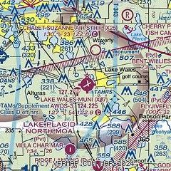
|
| Airport distance calculator |
|---|
|
|
| Sunrise and sunset |
|---|
|
Times for 17-Nov-2025
| | Local
(UTC-5) | | Zulu
(UTC) |
|---|
| Morning civil twilight | | 06:26 | | 11:26 |
| Sunrise | | 06:50 | | 11:50 |
| Sunset | | 17:32 | | 22:32 |
| Evening civil twilight | | 17:57 | | 22:57 |
|
| Current date and time |
|---|
| Zulu (UTC) | 17-Nov-2025 23:44:15 |
|---|
| Local (UTC-5) | 17-Nov-2025 18:44:15 |
|---|
|
| METAR |
|---|
KBOW
8nm W | 172320Z AUTO 06004KT 10SM CLR 21/18 A3000 RMK AO2 PWINO
|
KGIF
12nm NW | 172253Z AUTO 05004KT 10SM CLR 23/17 A3000 RMK AO1 SLP156 T02330172
|
|
| TAF |
|---|
KLAL
21nm W | 171736Z 1718/1818 33005KT P6SM FEW250 FM172300 VRB03KT P6SM BKN250
|
KISM
25nm NE | 171741Z 1718/1818 33006KT P6SM FEW020 SCT045 FM172200 04006KT P6SM SCT050 FM180800 35003KT P6SM MIFG SCT300 TEMPO 1811/1813 5SM BR FM181400 04004KT P6SM FEW035
|
|
| NOTAMs |
|---|
NOTAMs are issued by the DoD/FAA and will open in a separate window not controlled by AirNav.
|
|


