FAA INFORMATION EFFECTIVE 25 DECEMBER 2025
Location
| FAA Identifier: | X26 |
| Lat/Long: | 27-48-47.7000N 080-29-44.1000W
27-48.795000N 080-29.735000W
27.8132500,-80.4955833
(estimated) |
| Elevation: | 21.5 ft. / 6.6 m (surveyed) |
| Variation: | 06W (2010) |
| From city: | 1 mile W of SEBASTIAN, FL |
| Time zone: | UTC -5 (UTC -4 during Daylight Saving Time) |
| Zip code: | 32958 |
Airport Operations
| Airport use: | Open to the public |
| Activation date: | 04/1959 |
| Control tower: | no |
| ARTCC: | MIAMI CENTER |
| FSS: | SAINT PETERSBURG FLIGHT SERVICE STATION |
| NOTAMs facility: | PIE (NOTAM-D service available) |
| Attendance: | MON-FRI 0800-1700 |
| Wind indicator: | lighted |
| Segmented circle: | yes |
| Lights: | PAPI OPRS CONSLY. ACTVT REIL RWY 5 & 23; MIRL RWY 5/23 - CTAF. |
| Beacon: | white-green (lighted land airport)
Operates sunset to sunrise. |
Airport Communications
| CTAF: | 123.05 |
| WX AWOS-3PT: | 118.125 (772-228-7020) |
| MIAMI ARTCC APPROACH: | 123.625 ;NORTH |
| MIAMI ARTCC DEPARTURE: | 123.625 ;NORTH |
| WX AWOS-3PT at X59 (9 nm N): | 119.525 |
| WX ASOS at VRB (10 nm SE): | 120.575 (772-978-9535) |
| WX ASOS at MLB (19 nm NW): | 132.55 (321-951-7575) |
Nearby radio navigation aids
| VOR radial/distance | | VOR name | | Freq | | Var |
|---|
| MLBr164/19.0 | | MELBOURNE VOR/DME | | 115.85 | | 07W |
Airport Services
| Fuel available: | 100LL
100LL:FUEL 24 HR CREDIT CARD SVC AVBL. |
| Parking: | tiedowns |
| Airframe service: | MINOR |
| Powerplant service: | MINOR |
| Bottled oxygen: | NONE |
| Bulk oxygen: | NONE |
Runway Information
Runway 5/23
| Dimensions: | 4023 x 75 ft. / 1226 x 23 m |
| Surface: | asphalt, in excellent condition |
| Weight bearing capacity: | | PCN 6 /F/B/Y/T | | Single wheel: | 22.0 |
|
| Runway edge lights: | medium intensity |
| RUNWAY 5 | | RUNWAY 23 |
| Latitude: | 27-48.521242N | | 27-48.989923N |
| Longitude: | 080-30.018500W | | 080-29.489750W |
| Elevation: | 18.4 ft. | | 21.5 ft. |
| Traffic pattern: | left | | right |
| Runway heading: | 051 magnetic, 045 true | | 231 magnetic, 225 true |
| Markings: | nonprecision, in good condition | | nonprecision, in good condition |
| Visual slope indicator: | 2-light PAPI on left | | 2-light PAPI on left |
| Runway end identifier lights: | yes | | yes |
| Touchdown point: | yes, no lights | | yes, no lights |
| Obstructions: | 37 ft. trees, 1090 ft. from runway, 120 ft. left of centerline, 24:1 slope to clear | | 45 ft. trees, 1520 ft. from runway, 135 ft. left of centerline, 29:1 slope to clear |
Runway 10/28
| Dimensions: | 3199 x 75 ft. / 975 x 23 m |
| Surface: | asphalt, in fair condition |
| Weight bearing capacity: | |
| RUNWAY 10 | | RUNWAY 28 |
| Latitude: | 27-48.843167N | | 27-48.842135N |
| Longitude: | 080-30.007970W | | 080-29.414267W |
| Elevation: | 18.3 ft. | | 20.8 ft. |
| Traffic pattern: | left | | right |
| Runway heading: | 096 magnetic, 090 true | | 276 magnetic, 270 true |
| Markings: | basic, in good condition | | basic, in good condition |
| Visual slope indicator: | 2-light PAPI on left | | 2-light PAPI on left |
| Touchdown point: | yes, no lights | | yes, no lights |
| Obstructions: | 29 ft. trees, 735 ft. from runway, 125 ft. left of centerline, 18:1 slope to clear
RWY 10 APRCH SLOPE 24:1 TO AER. | | 20 ft. trees, 665 ft. from runway, 65 ft. right of centerline, 23:1 slope to clear |
Airport Ownership and Management from official FAA records
| Ownership: | Publicly-owned |
| Owner: | CITY OF SEBASTIAN
1225 MAIN STREET
SEBASTIAN, FL 32958
Phone 772-638-8820
CTC PERSON: BRIAN BENTON 772-638-8820 |
| Manager: | JEFFREY SABO
202 AIRPORT DRIVE EAST
SEBASTIAN, FL 32958
Phone 772-228-7013 |
Additional Remarks
| - | TREES & BRUSH IN ALL TRSN SFCS RWY 5/23. |
| - | NOISE ABATEMENT PROCS IN EFCT: CTC AMGR 772-633-0897. |
| - | IDENTIFICATION RQR FOR ARPT ACCESS. |
| - | EXTSV PRCHT OPNS. AVOID OVERFLYING ARPT DURG PRCHT OPNS. |
| - | FOR CD CTC PALM BEACH APCH AT 561-275-1430 |
Instrument Procedures
NOTE: All procedures below are presented as PDF files. If you need a reader for these files, you should download the free Adobe Reader.NOT FOR NAVIGATION. Please procure official charts for flight.
FAA instrument procedures published for use from 25 December 2025 at 0901z to 22 January 2026 at 0900z.
IAPs - Instrument Approach Procedures |
|---|
| RNAV (GPS)-A | |
download (219KB) |
| NOTE: Special Take-Off Minimums/Departure Procedures apply | |
download (296KB) |
Other nearby airports with instrument procedures:
X59 - Valkaria Airport (9 nm N)
KVRB - Vero Beach Regional Airport (10 nm SE)
KMLB - Melbourne Orlando International Airport (19 nm NW)
KFPR - Treasure Coast International Airport (20 nm S)
KCOF - Patrick Space Force Base Airport (26 nm N)
|
|

Road maps at:
MapQuest
Bing
Google
| Aerial photo |
|---|
WARNING: Photo may not be current or correct
 Photo taken 24-Jan-2013
looking west.
Photo taken 24-Jan-2013
looking west.
Do you have a better or more recent aerial photo of Sebastian Municipal Airport that you would like to share? If so, please send us your photo.
|
| Sectional chart |
|---|
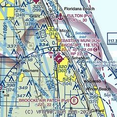
|
CAUTION: Diagram may not be current

| Airport distance calculator |
|---|
|
|
| Sunrise and sunset |
|---|
|
Times for 11-Jan-2026
| | Local
(UTC-5) | | Zulu
(UTC) |
|---|
| Morning civil twilight | | 06:50 | | 11:50 |
| Sunrise | | 07:16 | | 12:16 |
| Sunset | | 17:45 | | 22:45 |
| Evening civil twilight | | 18:10 | | 23:10 |
|
| Current date and time |
|---|
| Zulu (UTC) | 11-Jan-2026 12:27:57 |
|---|
| Local (UTC-5) | 11-Jan-2026 07:27:57 |
|---|
|
| METAR |
|---|
| KX26 | 111215Z AUTO 23004KT 1/2SM FG OVC001 16/16 A3013 RMK AO2 VIS 1/4V1 1/4
|
KVRB
11nm SE | 111153Z 25006KT 8SM CLR 18/17 A3014 RMK AO2 SLP206 T01780172 10183 20156 53006 $
|
KMLB
19nm NW | 111153Z 25003KT 10SM CLR 17/16 A3013 RMK AO2 SLP201 T01670156 10200 20167 53005
|
KFPR
20nm S | 111153Z 25004KT 10SM CLR 17/16 A3014 RMK AO2 SLP204 T01670161 10172 20144 53005
|
|
| TAF |
|---|
KVRB
11nm SE | 111120Z 1112/1212 24004KT P6SM SCT040 FM111500 25009KT P6SM FEW040 SCT250 FM112000 34012G20KT P6SM SCT050 FM120000 36014G22KT P6SM SCT025 BKN040 FM120800 01010KT P6SM SCT030 BKN040 OVC250
|
KMLB
19nm NW | 111120Z 1112/1212 VRB06KT P6SM SCT040 FM111500 25009KT P6SM SCT040 SCT250 FM111900 33012G18KT P6SM VCSH SCT045 FM112200 36015G25KT P6SM SCT020 BKN045 FM120800 01010KT P6SM SCT030 BKN040 OVC250
|
KFPR
20nm S | 111120Z 1112/1212 23003KT P6SM SCT040 TEMPO 1112/1113 4SM BR FM111500 25007KT P6SM FEW040 SCT250 FM112000 33010G15KT P6SM SCT050 FM120000 36012G20KT P6SM SCT025 BKN040 FM120800 01010KT P6SM SCT030 BKN040 OVC250
|
|
| NOTAMs |
|---|
NOTAMs are issued by the DoD/FAA and will open in a separate window not controlled by AirNav.
|
|


