FAA INFORMATION EFFECTIVE 14 MAY 2026
Location
| FAA Identifier: | X59 |
| Lat/Long: | 27-57-39.1160N 080-33-29.9800W
27-57.651933N 080-33.499667W
27.9608656,-80.5583278
(estimated) |
| Elevation: | 25.8 ft. / 7.9 m (surveyed) |
| Variation: | 07W (2025) |
| From city: | 1 mile W of VALKARIA, FL |
| Time zone: | UTC -4 (UTC -5 during Standard Time) |
| Zip code: | 32950 |
Airport Operations
| Airport use: | Open to the public |
| Activation date: | 12/1946 |
| Control tower: | no |
| ARTCC: | JACKSONVILLE CENTER |
| FSS: | SAINT PETERSBURG FLIGHT SERVICE STATION |
| NOTAMs facility: | PIE (NOTAM-D service available) |
| Attendance: | MON-FRI 0800-1700 |
| Wind indicator: | lighted |
| Segmented circle: | yes |
| Lights: | APLG NOT OPR DURG DALGT HOURS. SS-SR, ACTVT MIRL 14/32- CTAF. |
| Beacon: | white-green (lighted land airport)
Operates sunset to sunrise. |
Airport Communications
| CTAF/UNICOM: | 122.725 |
| WX AWOS-3PT: | 119.525 |
| ORLANDO APPROACH: | 126.025 |
| ORLANDO DEPARTURE: | 126.025 |
| WX AWOS-3PT at X26 (9 nm S): | 118.125 (772-228-7020) |
| WX ASOS at MLB (10 nm NW): | 132.55 (321-237-1257) |
| WX ASOS at VRB (20 nm S): | 120.575 (772-978-9535) |
Nearby radio navigation aids
| VOR radial/distance | | VOR name | | Freq | | Var |
|---|
| MLBr162/9.6 | | MELBOURNE VOR/DME | | 115.85 | | 07W |
Airport Services
| Fuel available: | 100LL |
| Parking: | tiedowns |
| Airframe service: | MAJOR |
| Powerplant service: | MAJOR |
| Bottled oxygen: | NONE |
| Bulk oxygen: | NONE |
Runway Information
Runway 10/28
| Dimensions: | 4000 x 75 ft. / 1219 x 23 m |
| Surface: | asphalt, in fair condition |
| Weight bearing capacity: | | PCN 6 /F/B/Y/T | | Single wheel: | 12.5 |
|
| RUNWAY 10 | | RUNWAY 28 |
| Latitude: | 27-57.574833N | | 27-57.572667N |
| Longitude: | 080-33.947167W | | 080-33.203500W |
| Elevation: | 23.5 ft. | | 25.7 ft. |
| Traffic pattern: | left | | left |
| Markings: | basic, in fair condition | | basic, in fair condition |
| Visual slope indicator: | | | 4-light PAPI on right (3.00 degrees glide path) |
| Touchdown point: | yes, no lights | | yes, no lights |
| Obstructions: | 37 ft. trees, 735 ft. from runway, 90 ft. right of centerline, 14:1 slope to clear | | 20 ft. trees, 430 ft. from runway, 120 ft. left of centerline, 11:1 slope to clear |
Runway 14/32
| Dimensions: | 4000 x 75 ft. / 1219 x 23 m |
| Surface: | asphalt, in good condition |
| Weight bearing capacity: | | PCN 8 /F/A/Y/T | | Single wheel: | 12.5 |
|
| Runway edge lights: | medium intensity |
| RUNWAY 14 | | RUNWAY 32 |
| Latitude: | 27-57.974538N | | 27-57.485717N |
| Longitude: | 080-33.673700W | | 080-33.174217W |
| Elevation: | 24.6 ft. | | 24.2 ft. |
| Traffic pattern: | left | | left |
| Markings: | nonprecision, in fair condition | | nonprecision, in fair condition |
| Visual slope indicator: | 4-light PAPI on right (3.00 degrees glide path) | | 4-light PAPI on left (3.00 degrees glide path) |
| Touchdown point: | yes, no lights | | yes, no lights |
| Obstructions: | 23 ft. trees, 485 ft. from runway, 95 ft. left of centerline, 12:1 slope to clear | | 21 ft. trees, 460 ft. from runway, 125 ft. left of centerline, 12:1 slope to clear |
Airport Ownership and Management from official FAA records
| Ownership: | Publicly-owned |
| Owner: | BREVARD COUNTY
2725 JUDGE FRAN JAMIESON WAY, BUILDING C SUITE 301
VIERA, FL 32940
Phone 321-633-2001 |
| Manager: | PHILLIP HIED
1 PILOT'S PLACE
VALKARIA, FL 32950
Phone 321-952-4590 |
Additional Remarks
| - | USE CTN EXTSV PWRD PARAGLIDER OPS. |
| - | FOR CD OR TO CNL IFR CTC ORLANDO APCH AT 407-852-7500. |
| - | TSNT GATE CODE 1467. |
| - | FM TOUCH & GO OPNS PROHIBITED IF THERE ARE 3 OR MORE ACFT IN THE TFC PAT. |
| - | TRANSIENT AIRCRAFT PLEASE PARK ON APRON BETWEEN AIRPORT BEACON AND TERMINAL. |
| - | PPR FOR ACFT EQUIPPED WITH WEATHER MODIFICATION OR GEOENGINEERING EQPT CALL 321-952-4590 MON-FRI 0800-1700 EXCLD HOLS. |
Instrument Procedures
NOTE: All procedures below are presented as PDF files. If you need a reader for these files, you should download the free Adobe Reader.NOT FOR NAVIGATION. Please procure official charts for flight.
FAA instrument procedures published for use from 14 May 2026 at 0901Z to 11 June 2026 at 0900Z.
IAPs - Instrument Approach Procedures |
|---|
| RNAV (GPS)-A | |
download (170KB) |
| RNAV (GPS)-A | |
download (170KB) |
| RNAV (GPS)-B | |
download (179KB) |
| RNAV (GPS)-B | |
download (179KB) |
| NOTE: Special Alternate Minimums apply | |
download (149KB) |
| NOTE: Special Alternate Minimums apply | |
download (149KB) |
| NOTE: Special Take-Off Minimums/Departure Procedures apply | |
download (409KB) |
| NOTE: Special Take-Off Minimums/Departure Procedures apply | |
download (409KB) |
Other nearby airports with instrument procedures:
X26 - Sebastian Municipal Airport (9 nm S)
KMLB - Melbourne Orlando International Airport (10 nm NW)
KCOF - Patrick Space Force Base Airport (17 nm N)
KVRB - Vero Beach Regional Airport (20 nm S)
KCOI - Merritt Island Airport (24 nm N)
|
|

Road maps at:
MapQuest
Bing
Google
| Aerial photo |
|---|
WARNING: Photo may not be current or correct
 Photo by Lance Jackson
looking southeast
Photo by Lance Jackson
looking southeast
Do you have a better or more recent aerial photo of Valkaria Airport that you would like to share? If so, please send us your photo.
|
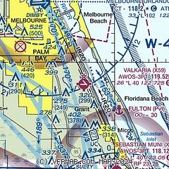
| Sectional chart |
|---|
|
| Airport distance calculator |
|---|
|
|
| Sunrise and sunset |
|---|
|
Times for 31-May-2026
| | Local
(UTC-4) | | Zulu
(UTC) |
|---|
| Morning civil twilight | | 06:01 | | 10:01 |
| Sunrise | | 06:27 | | 10:27 |
| Sunset | | 20:12 | | 00:12 |
| Evening civil twilight | | 20:39 | | 00:39 |
|
| Current date and time |
|---|
| Zulu (UTC) | 01-Jun-2026 01:40:20 |
|---|
| Local (UTC-4) | 31-May-2026 21:40:20 |
|---|
|
| METAR |
|---|
KX26
9nm S | 010055Z AUTO 19002KT 10SM BKN046 BKN050 BKN120 26/26 A2998 RMK AO2
|
KMLB
10nm NW | 010106Z 16007KT 10SM FEW007 FEW055 24/23 A2997 RMK AO2 RAE0058 TSE00 P0000 T02440228 $
|
KCOF
15nm N | 010055Z AUTO 19004KT 10SM VCTS FEW007 BKN130 25/23 A2993 RMK AO2 RAB09E32 TSB2355E42 SLP140 P0000 T02540229
|
|
| TAF |
|---|
KMLB
10nm NW | 010014Z 0100/0124 16008KT P6SM VCTS FEW050CB FEW080 BKN120 TEMPO 0100/0101 33012G20KT 2SM TSRA FEW010 BKN025CB FM010300 19004KT P6SM FEW050 SCT150 FM011400 29013G21KT P6SM SCT030 SCT080 BKN100 FM011700 30012G20KT P6SM VCTS SCT050CB BKN120 FM012300 31008KT P6SM FEW035 FEW060 SCT140
|
|
| NOTAMs |
|---|
NOTAMs are issued by the DoD/FAA and will open in a separate window not controlled by AirNav.
|
|


