FAA INFORMATION EFFECTIVE 15 MAY 2025
Location
| FAA Identifier: | L70 |
| Lat/Long: | 34-30-12.6534N 118-18-47.3658W
34-30.210890N 118-18.789430W
34.5035148,-118.3131572
(estimated) |
| Elevation: | 2633 ft. / 803 m (estimated) |
| Variation: | 14E (1985) |
| From city: | 2 miles E of AGUA DULCE, CA |
| Time zone: | UTC -7 (UTC -8 during Standard Time) |
| Zip code: | 91350 |
Airport Operations
| Airport use: | Open to the public |
| Activation date: | 10/1958 |
| Control tower: | no |
| ARTCC: | LOS ANGELES CENTER |
| FSS: | RIVERSIDE FLIGHT SERVICE STATION |
| NOTAMs facility: | RAL (NOTAM-D service available) |
| Attendance: | 0800-1800
AIRPORT UNATNDD CHRISTMAS DAY; THANKSGIVING DAY AND NEW YEARS DAY. |
| Wind indicator: | yes |
| Segmented circle: | yes |
Airport Communications
| CTAF/UNICOM: | 122.8 |
| WX ASOS at PMD (14 nm NE): | PHONE 661-272-3798 |
| WX ASOS at WJF (15 nm N): | PHONE 661-949-2840 |
| WX AWOS-3PT at WHP (15 nm S): | 132.1 (818-899-9820) |
| WX ASOS at BUR (18 nm S): | PHONE 818-841-1384 |
| WX ASOS at VNY (20 nm SW): | PHONE 818-904-9213 |
Nearby radio navigation aids
| VOR radial/distance | | VOR name | | Freq | | Var |
|---|
| PMDr223/14.5 | | PALMDALE VORTAC | | 115.55 | | 15E |
| LHSr115/16.9 | | LAKE HUGHES VORTAC | | 114.35 | | 15E |
| VNYr013/19.0 | | VAN NUYS VOR/DME | | 113.10 | | 15E |
| FIMr058/29.5 | | FILLMORE VORTAC | | 112.50 | | 15E |
| SMOr359/30.4 | | SANTA MONICA VOR/DME | | 110.80 | | 15E |
| GMNr108/32.5 | | GORMAN VORTAC | | 116.10 | | 16E |
| LAXr355/34.7 | | LOS ANGELES VORTAC | | 113.60 | | 15E |
| POMr299/36.5 | | POMONA VORTAC | | 110.40 | | 15E |
Airport Services
| Fuel available: | 100LL
100LL:SELF SERVICE |
| Parking: | tiedowns |
| Airframe service: | NONE |
| Powerplant service: | NONE |
| Bottled oxygen: | NONE |
| Bulk oxygen: | NONE |
Runway Information
Runway 4/22
| Dimensions: | 4205 x 50 ft. / 1282 x 15 m |
| Surface: | asphalt, in good condition |
| RUNWAY 4 | | RUNWAY 22 |
| Latitude: | 34-30.002603N | | 34-30.419177N |
| Longitude: | 118-19.124070W | | 118-18.454788W |
| Elevation: | 2556.0 ft. | | 2633.0 ft. |
| Traffic pattern: | left | | right |
| Displaced threshold: | 180 ft. | | 332 ft. |
| Markings: | basic, in good condition | | basic, in good condition |
| Runway end identifier lights: | no | | no |
| Touchdown point: | yes, no lights | | yes, no lights |
| Obstructions: | 15 ft. bldg, 240 ft. from runway, 85 ft. right of centerline, 2:1 slope to clear
RWY 04 +15 FT HANGER 140-160 FT FM EOR 80 FT RIGHT. | | 4 ft. fence, 200 ft. from runway, 35 ft. right of centerline
+4 FT FENCE 0 FT - 200 FT FROM EOR DIAGONALLY FROM 50 FT LEFT TO 35 FT RIGHT. |
Airport Ownership and Management from official FAA records
| Ownership: | Privately-owned |
| Owner: | LAND SEA AIR LEASING CORPORATION
15853 OLDEN STREET, P.O. BOX 9203
SYLMAR, CA 91392
Phone (661) 268-8835 |
| Manager: | JON BONNER
33638 AGUA DULCE CANYON ROAD, P. O. BOX 9203
AGUA DULCE, CA 91390
Phone (661) 268-8835
DOUG ABNEY, ASST ARPT OPNS - PHONE 661-268-8835 CELL 661-268-8835. EMAIL: SUPPORT@L70AIRPORT.COM |
Additional Remarks
| - | RIDGE SOUTH OF AIRPORT PARALLEL TO RY VIOLATES 7:1 TRANSITIONAL SURFACE. |
| - | FORMATION ARRIVALS AND DEPARTURES PROHIBITED. |
| - | NO AEROBATICS PERMITTED. |
| - | AIRPORT CLSD SUNSET TO SUNRISE. ALL NIGHT OPERATIONS PROHIBITED BY LOCAL RESTRICTIONS. |
| - | ACTVT MIKE 5 TIMES ON CTAF FREQ FOR ARPT WX. |
| - | FOR CD CTC JOSHUA APCH AT 661-277-3843. |
| - | 10-25 FT WIDE DITCH AT 170 FT ALONG SE EDGE OF RY. |
| - | TGL NOT PERMITTED. |
| - | AVOID FLYING WITHIN 1000 FT OF SCHOOL APRXLY ONE MILE SOUTHWEST. RY 04 DEP AVOID FLYING OVER HOMES 2,000 FT NE OF RY END. |
Instrument Procedures
There are no published instrument procedures at L70.
Some nearby airports with instrument procedures:
KPMD - Palmdale USAF Plant 42 Airport (14 nm NE)
KWJF - General Wm J Fox Airfield (15 nm N)
KWHP - Whiteman Airport (15 nm S)
KBUR - Bob Hope Airport (18 nm S)
KVNY - Van Nuys Airport (20 nm SW)
|
|

Road maps at:
MapQuest
Bing
Google
| Aerial photo |
|---|
WARNING: Photo may not be current or correct
 Photo by Mark Robinson & eatsleepfly.com
Photo taken 08-Mar-2014
looking northwest.
Photo by Mark Robinson & eatsleepfly.com
Photo taken 08-Mar-2014
looking northwest.
Do you have a better or more recent aerial photo of Agua Dulce Airport that you would like to share? If so, please send us your photo.
|
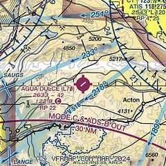
| Sectional chart |
|---|
|
| Airport distance calculator |
|---|
|
|
| Sunrise and sunset |
|---|
|
Times for 23-May-2025
| | Local
(UTC-7) | | Zulu
(UTC) |
|---|
| Morning civil twilight | | 05:18 | | 12:18 |
| Sunrise | | 05:46 | | 12:46 |
| Sunset | | 19:53 | | 02:53 |
| Evening civil twilight | | 20:22 | | 03:22 |
|
| Current date and time |
|---|
| Zulu (UTC) | 23-May-2025 20:04:08 |
|---|
| Local (UTC-7) | 23-May-2025 13:04:08 |
|---|
|
| METAR |
|---|
KWJF
14nm N | 231956Z 24023G31KT 10SM CLR 28/07 A2990 RMK AO2 PK WND 24032/1919 SLP105 T02780072
|
KPMD
14nm NE | 231953Z 26019KT 10SM CLR 28/03 A2991 RMK AO2 PK WND 29028/1905 SLP100 T02830033
|
KWHP
16nm S | 231955Z 12008KT 9SM SKC 23/12 A2996
|
KBUR
18nm S | 231953Z 21008KT 10SM CLR 23/12 A2994 RMK AO2 SLP127 T02280122
|
KVNY
19nm SW | 231951Z 15009G15KT 10SM CLR 23/12 A2993 RMK AO2 SLP129 T02330117
|
KMWS
21nm SE | 231820Z 26003G05KT 17/07
|
KSDB
25nm NW | 231951Z AUTO 15011G20KT 10SM CLR 23/07 A3004 RMK AO2 SLP123 T02280067
|
|
| TAF |
|---|
KWJF
14nm N | 231731Z 2318/2418 24020G28KT P6SM SKC FM240500 24015KT P6SM SKC FM241600 25018G26KT P6SM FEW250
|
KPMD
14nm NE | 231731Z 2318/2418 24020G30KT P6SM SKC FM240400 24015KT P6SM SKC FM241600 23015G25KT P6SM FEW250
|
KBUR
18nm S | 231731Z 2318/2418 18010KT P6SM SKC FM240400 15006KT P6SM SKC FM240800 14008KT P6SM OVC012
|
KVNY
19nm SW | 231731Z 2318/2418 15012KT P6SM SKC FM240300 13006KT P6SM SKC FM240800 14006KT P6SM OVC012
|
|
| NOTAMs |
|---|
NOTAMs are issued by the DoD/FAA and will open in a separate window not controlled by AirNav.
|
|


