FAA INFORMATION EFFECTIVE 23 JANUARY 2025
Location
| FAA Identifier: | TUS |
| Lat/Long: | 32-07-01.4455N 110-56-29.2661W
32-07.024092N 110-56.487768W
32.1170682,-110.9414628
(estimated) |
| Elevation: | 2643 ft. / 805.6 m (surveyed) |
| Variation: | 09E (2025) |
| From city: | 6 miles S of TUCSON, AZ |
| Time zone: | UTC -7 (year round; does not observe DST) |
| Zip code: | 85706 |
Airport Operations
| Airport use: | Open to the public |
| Activation date: | 11/1941 |
| Control tower: | yes |
| ARTCC: | ALBUQUERQUE CENTER |
| FSS: | PRESCOTT FLIGHT SERVICE STATION |
| NOTAMs facility: | TUS (NOTAM-D service available) |
| Attendance: | CONTINUOUS |
| Pattern altitude: | 3443 ft. MSL
TPA 800 FT AGL SMALL ACFT; 1400 FT AGL LARGE/HEAVY TURBOJET ACFT. |
| Wind indicator: | lighted |
| Segmented circle: | no |
| Lights: | SS-SR |
| Beacon: | white-green (lighted land airport)
Operates sunset to sunrise. |
| Fire and rescue: | ARFF index C |
| International operations: | international airport of entry |
Airport Communications
| UNICOM: | 122.95 |
| ATIS: | 123.8 279.65 |
| WX ASOS: | PHONE 520-295-5727 |
| TUCSON GROUND: | 120.025 348.6 |
| TUCSON TOWER: | 118.3 257.8 119.0 |
| TUCSON APPROACH: | 119.4 ;RWY 12 286-089 TUS 119.4 ;RWY 30 066-274 TUS 125.1 ;RWY 12 090-285 TUS 125.1 ;RWY 30 275-065 TUS 128.5 |
| TUCSON DEPARTURE: | 119.4 ;RWY 12 286-089 TUS 119.4 ;RWY 30 066-274 TUS 125.1 ;RWY 12 090-285 TUS 125.1 ;RWY 30 275-065 TUS |
| CLEARANCE DELIVERY: | 126.65 326.2 |
| ANG COMD POST: | 138.525 |
| BURRO DP: | 125.1 ;RWY 12 |
| CLASS C: | 119.4 ;RWY 12, 286-089 TUS 119.4 ;RWY 30 066-274 TUS 125.1 ;RWY 12 090-285 TUS 125.1 ;RWY 30 275-065 TUS |
| DINGO STAR: | 119.4 ;RWY 12 125.1 ;RWY 30 |
| EMERG: | 121.5 243.0 |
| IC: | 119.4 ;RWY 12 286-089 TUS |
| TUCSON DP: | 125.1 |
| WLDKT DP: | 125.1 ;RWY 30 |
| WX AWOS-3 at RYN (12 nm W): | 133.35 (520-578-0269) |
Nearby radio navigation aids
| VOR radial/distance | | VOR name | | Freq | | Var |
|---|
| TUSr302/1.9 | | TUCSON VORTAC | | 116.00 | | 12E |
| NDB name | | Hdg/Dist | | Freq | | Var | | ID |
|---|
| RYAN | | 085/11.3 | | 338 | | 12E | | RYN | .-. -.-- -. |
| ROBLES | | 071/21.4 | | 220 | | 12E | | RBJ | .-. -... .--- |
Airport Services
| Fuel available: | 100LL JET-A JET-A++ |
| Parking: | tiedowns |
| Airframe service: | MAJOR |
| Powerplant service: | MAJOR |
| Bottled oxygen: | HIGH/LOW |
| Bulk oxygen: | HIGH/LOW |
Runway Information
Runway 12/30
| Dimensions: | 10996 x 150 ft. / 3352 x 46 m |
| Surface: | asphalt/grooved, in good condition |
| Weight bearing capacity: | | Single wheel: | 120.0 | | Double wheel: | 214.0 | | Double tandem: | 405.0 | | Dual double tandem: | 918.0 |
|
| Runway edge lights: | high intensity
EXCEEDS 200 FT SPACING AT TWY INTXN ON N & S SIDE OF RWY. |
| Operational restrictions: | FIXED WING JET VSTOL/VTOL OPS NA. DSTC RMNG MKRS NE SIDE. |
| RUNWAY 12 | | RUNWAY 30 |
| Latitude: | 32-07.402148N | | 32-06.119330N |
| Longitude: | 110-56.874753W | | 110-55.369068W |
| Elevation: | 2577.7 ft. | | 2643.0 ft. |
| Traffic pattern: | left | | right |
| Runway heading: | 126 magnetic, 135 true | | 306 magnetic, 315 true |
| Declared distances: | TORA:10996 TODA:10996 ASDA:10996 LDA:10996 | | TORA:10996 TODA:10996 ASDA:10996 LDA:10996 |
| Markings: | precision, in good condition | | nonprecision, in good condition |
| Visual slope indicator: | 4-light PAPI on left (3.00 degrees glide path) | | 4-light PAPI on left (3.00 degrees glide path) |
| RVR equipment: | touchdown | | rollout |
| Approach lights: | MALSR: 1,400 foot medium intensity approach lighting system with runway alignment indicator lights | | |
| Runway end identifier lights: | | | yes |
| Touchdown point: | yes, no lights | | yes, no lights |
| Instrument approach: | ILS/DME | | |
| Obstructions: | none | | 8 ft. gnd, 400 ft. from runway, 500 ft. right of centerline, 25:1 slope to clear |
Runway 4/22
| Dimensions: | 7000 x 150 ft. / 2134 x 46 m |
| Surface: | asphalt/grooved, in good condition |
| Weight bearing capacity: | | Single wheel: | 119.0 | | Double wheel: | 209.0 | | Double tandem: | 393.0 | | Dual double tandem: | 830.0 |
|
| Runway edge lights: | medium intensity |
| RUNWAY 4 | | RUNWAY 22 |
| Latitude: | 32-07.029958N | | 32-07.845602N |
| Longitude: | 110-57.542397W | | 110-56.582558W |
| Elevation: | 2560.2 ft. | | 2568.8 ft. |
| Traffic pattern: | left | | right |
| Runway heading: | 036 magnetic, 045 true | | 216 magnetic, 225 true |
| Displaced threshold: | 850 ft. | | no |
| Declared distances: | TORA:7000 TODA:7000 ASDA:7000 LDA:6150 | | TORA:6000 TODA:7000 ASDA:6000 LDA:6000 |
| Markings: | nonprecision, in good condition | | nonprecision, in good condition |
| Visual slope indicator: | | | 4-light PAPI on left (3.00 degrees glide path) |
| Runway end identifier lights: | | | yes |
| Touchdown point: | yes, no lights | | yes, no lights |
| Obstructions: | 21 ft. rr, 270 ft. from runway, 250 ft. left of centerline, 3:1 slope to clear | | none |
Airport Ownership and Management from official FAA records
| Ownership: | Publicly-owned |
| Owner: | TUCSON AIRPORT AUTHORITY
7250 SOUTH TUCSON BLVD, SUITE 300
TUCSON, AZ 85756
Phone 520-573-8100 |
| Manager: | DANETTE BEWLEY
TUCSON APT AUTH 7250 S TUCSON BLVD, SUITE 300
TUCSON, AZ 85756
Phone 520-573-4820
ADAM MERRILL 520-573-5112. |
Additional Remarks
| A39-12/30 | PCR VALUE: 650/R/A/W/T |
| A39-04/22 | PCR VALUE: 470/F/A/X/T |
| A30A-30 | CTN: ENSURE DEP RWY; DO NOT MISTAKE FOR DEMOL RWY. |
| E60-30 | BAK-14 BAK-12(B) (1215) HOOK BAK 12B(B) (128 OVRN). |
| E60-12 | BAK-14 BAK-12B(B) (1000). |
| E60-04 | BAK-14 BAK-12B(B) (1500). |
| - | CTN: NW ARR & DEP DO NOT MISTAKE TWY A FOR LNDG SFC; TWY A N & PARL TO RWY 30. |
| - | GROUP V TAX WITH INBOARD ENG ONLY. TRML RAMP CLSD TO ADG IV & ABV WO PPR. |
| - | PTNS TWY D NOT VIS FM ATCT. |
| - | ACR USE RWY 04/22 & 12/30. |
| - | A-GEAR BAK-14/BAK-12B APCH END RWY 12 & BAK-14/BAK-12B APCH END RWY 30 AVBL DURG ANG DUTY HR; 5 MIN PN. |
| - | TWY A5 LTD 70000 LB OR LESS. |
| - | MIL: ANG OFFL BUS ONLY; 72 HR PPR - D844-6731/C520-295-6731; FAX EXTN 6732. BASE OPS 1300Z-2300Z MON-FRI & DRILL WKEND 1300Z-2130Z; CLSD OTR WKENDS, HOL & SKED OFF DAYS. TRAN ALERT MAINT NA. TSNT SI FSL ONLY. CONTR FUEL NA. |
| - | USE UPPER ANT UNTIL AIRBORNE. |
| - | CHARTER, SPORT TEAM, CARGO & MIL PPR - FBO. LNDG & PRKG FEE 12500 LBS & UP. |
| - | MIL/COMM/BASE OPS ARR CTC TITAN OR PUMA - ANG BASE OPS/COMD POST FREQ. |
| - | MIL: BIRD ACT PHASE II IN EFCT 1 JUL-31 AUG. |
| - | USCBP INSP RAMP RFLG NA EXC MED EMERG. |
| - | GEN INFO - 520-573-8182. |
| - | CTN: REVIEW ARPT DIAGRAM HOT SPOT INFO. |
| - | OPR PARROT ALL SFCS, PUSHBACK & GATE ARR. |
| - | N RAMP CLSD TO WINGSPAN GTR THAN 79 FT. |
| - | TXL K CLSD TO WINGSPAN GTR THAN 104 FT. |
| - | FLT TRNG 2200-0600 NA EXC PPR - 520-573-8190. |
Instrument Procedures
NOTE: All procedures below are presented as PDF files. If you need a reader for these files, you should download the free Adobe Reader.NOT FOR NAVIGATION. Please procure official charts for flight.
FAA instrument procedures published for use from 23 January 2025 at 0901Z to 20 February 2025 at 0900z.
STARs - Standard Terminal Arrivals |
|---|
| DINGO SIX | |
download (229KB) |
| ZONNA TWO (RNAV) | |
download (209KB) |
IAPs - Instrument Approach Procedures |
|---|
| ILS OR LOC RWY 12 | |
download (413KB) |
| RNAV (RNP) Y RWY 12 | |
download (344KB) |
| RNAV (RNP) Y RWY 30 | |
download (344KB) |
| RNAV (GPS) RWY 04 | |
download (322KB) |
| RNAV (GPS) RWY 22 | |
download (361KB) |
| RNAV (GPS) Z RWY 12 | |
download (366KB) |
| RNAV (GPS) Z RWY 30 | |
download (360KB) |
| VOR OR TACAN RWY 12 | |
download (334KB) |
| VOR OR TACAN RWY 30 | |
download (290KB) |
| NOTE: Special Alternate Minimums apply | |
download (142KB) |
Departure Procedures |
|---|
| BURRO FIVE (RNAV) | |
download (195KB) |
| TUCSON NINE | |
2 pages:
[1] [2] (395KB) |
| WLDKT FOUR (RNAV) | |
download (181KB) |
| NOTE: Special Take-Off Minimums/Departure Procedures apply | |
download (384KB) |
Other nearby airports with instrument procedures:
KDMA - Davis Monthan Air Force Base (4 nm NE)
KRYN - Ryan Field Airport (12 nm W)
KAVQ - Marana Regional Airport (22 nm NW)
KOLS - Nogales International Airport (42 nm S)
KFHU - Sierra Vista Municipal Airport-Libby Army Airfield (44 nm SE)
|
|

Road maps at:
MapQuest
Bing
Google
| Aerial photo |
|---|
WARNING: Photo may not be current or correct
 Photo by Trent Thomas
Photo taken 09-Aug-2018
looking east.
Photo by Trent Thomas
Photo taken 09-Aug-2018
looking east.
Do you have a better or more recent aerial photo of Tucson International Airport that you would like to share? If so, please send us your photo.
|
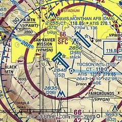
| Sectional chart |
|---|
|
CAUTION: Diagram may not be current
 Download PDF
of official airport diagram from the FAA
| Airport distance calculator |
|---|
|
|
| Sunrise and sunset |
|---|
|
Times for 05-Feb-2025
| | Local
(UTC-7) | | Zulu
(UTC) |
|---|
| Morning civil twilight | | 06:50 | | 13:50 |
| Sunrise | | 07:16 | | 14:16 |
| Sunset | | 18:00 | | 01:00 |
| Evening civil twilight | | 18:25 | | 01:25 |
|
| Current date and time |
|---|
| Zulu (UTC) | 05-Feb-2025 22:45:47 |
|---|
| Local (UTC-7) | 05-Feb-2025 15:45:47 |
|---|
|
| METAR |
|---|
| KTUS | 052153Z 35004KT 10SM CLR 27/M11 A2999 RMK AO2 SLP121 T02721111
|
KDMA
5nm NE | 052155Z AUTO 33008KT 10SM CLR 27/M22 A2996 RMK AO2 SLP117 T02671221 $
|
KRYN
12nm W | 052145Z 31011KT 10SM 27/M14 A2996
|
|
| TAF |
|---|
| KTUS | 051722Z 0518/0618 14005KT P6SM SKC FM052100 32007KT P6SM SKC FM060500 14005KT P6SM SKC
|
KDMA
5nm NE | 051900Z 0519/0701 06003KT 9999 SKC QNH2997INS BECMG 0520/0521 31009KT 9999 SKC QNH2994INS BECMG 0604/0605 14009KT 9999 SKC QNH3001INS BECMG 0618/0619 24009KT 9999 SKC QNH2995INS TX26/0522Z TN09/0612Z
|
|
| NOTAMs |
|---|
NOTAMs are issued by the DoD/FAA and will open in a separate window not controlled by AirNav.
|
|


