FAA INFORMATION EFFECTIVE 09 JULY 2026
Location
| FAA Identifier: | 0F4 |
| Lat/Long: | 41-17-10.9000N 098-59-24.1000W
41-17.181667N 098-59.401667W
41.2863611,-98.9900278
(estimated) |
| Elevation: | 2072.6 ft. / 631.7 m (surveyed) |
| Variation: | 05E (2015) |
| From city: | 1 mile NW of LOUP CITY, NE |
| Time zone: | UTC -5 (UTC -6 during Standard Time) |
| Zip code: | 68853 |
Airport Operations
| Airport use: | Open to the public |
| Activation date: | 05/1970 |
| Control tower: | no |
| ARTCC: | MINNEAPOLIS CENTER |
| FSS: | COLUMBUS FLIGHT SERVICE STATION |
| NOTAMs facility: | OLU (NOTAM-D service available) |
| Attendance: | UNATNDD
FOR SVC CALL 308-745-1244. |
| Wind indicator: | lighted |
| Segmented circle: | yes |
| Lights: | MIRL RWY 16/34 LOW INTST SS-SR; TO INCREASE - CTAF. PAPI RWY 16 & 34 - CTAF |
| Beacon: | white-green (lighted land airport)
Operates sunset to sunrise. |
Airport Communications
- APCH/DEP SVC PRVDD BY MINNEAPOLIS (ZMP) ARTCC ON FREQ 126.05 (GRAND ISLAND RCAG) / 278.8 (HASTINGS RCAG).
Nearby radio navigation aids
| VOR radial/distance | | VOR name | | Freq | | Var |
|---|
| CUZr103/33.6 | | CUSTER COUNTY VOR/DME | | 108.20 | | 08E |
| EARr356/(33.7) | | KEARNEY VOR | | 111.20 | | 05E |
| GRIr294/35.5 | | GRAND ISLAND VOR/DME | | 116.55 | | 07E |
| NDB name | | Hdg/Dist | | Freq | | Var | | ID |
|---|
| ORD | | 180/20.3 | | 356 | | 05E | | ODX | --- -.. -..- |
Airport Services
| Fuel available: | 100LL
100LL:FUEL AVBL H24 VIA CREDIT CARD. |
| Parking: | hangars and tiedowns |
| Airframe service: | NONE |
| Powerplant service: | NONE |
| Bottled oxygen: | NONE |
| Bulk oxygen: | NONE |
Runway Information
Runway 16/34
| Dimensions: | 3900 x 60 ft. / 1189 x 18 m |
| Surface: | concrete, in good condition |
| Weight bearing capacity: | |
| Runway edge lights: | medium intensity |
| RUNWAY 16 | | RUNWAY 34 |
| Latitude: | 41-17.488907N | | 41-16.866403N |
| Longitude: | 098-59.484637W | | 098-59.275532W |
| Elevation: | 2072.6 ft. | | 2067.6 ft. |
| Traffic pattern: | left | | left |
| Runway heading: | 161 magnetic, 166 true | | 341 magnetic, 346 true |
| Markings: | nonprecision, in good condition | | nonprecision, in good condition |
| Visual slope indicator: | 2-light PAPI on left (3.00 degrees glide path) | | 2-light PAPI on left (3.00 degrees glide path) |
| Runway end identifier lights: | no | | no |
| Touchdown point: | yes, no lights | | yes, no lights |
Runway 4/22
| Dimensions: | 2021 x 100 ft. / 616 x 30 m |
| Surface: | turf, in fair condition |
| RUNWAY 4 | | RUNWAY 22 |
| Latitude: | 41-17.079323N | | 41-17.295268N |
| Longitude: | 098-59.610578W | | 098-59.274927W |
| Elevation: | 2067.7 ft. | | 2069.5 ft. |
| Traffic pattern: | left | | left |
| Runway heading: | 045 magnetic, 050 true | | 225 magnetic, 230 true |
| Touchdown point: | yes, no lights | | yes, no lights |
| Obstructions: | 56 ft. trees, 981 ft. from runway, 178 ft. right of centerline, 17:1 slope to clear | | 32 ft. tree, 475 ft. from runway, 101 ft. left of centerline, 14:1 slope to clear |
Airport Ownership and Management from official FAA records
| Ownership: | Publicly-owned |
| Owner: | LOUP CITY AIRPORT AUTHORITY
PO BOX 29
LOUP CITY, NE 68853-0029
Phone 308-390-1500 |
| Manager: | MIKE KING
PO BOX 29
LOUP CITY, NE 68853-0029
Phone 308-390-1500 |
Additional Remarks
| A57-34 | CLNC SLP 26:1 ALSO DUE TO ROAD 631 FT OUT 16 FT ABV 0B. |
| - | FOR CD CTC MINNEAPOLIS ARTCC AT 651-463-5588. |
Instrument Procedures
NOTE: All procedures below are presented as PDF files. If you need a reader for these files, you should download the free Adobe Reader.NOT FOR NAVIGATION. Please procure official charts for flight.
FAA instrument procedures published for use from 09 July 2026 at 0901Z to 06 August 2026 at 0900Z.
IAPs - Instrument Approach Procedures |
|---|
| RNAV (GPS) RWY 16 | |
download (220KB) |
| RNAV (GPS) RWY 34 | |
download (231KB) |
| NOTE: Special Take-Off Minimums/Departure Procedures apply | |
download (194KB) |
Other nearby airports with instrument procedures:
KODX - Evelyn Sharp Field Airport (20 nm N)
KBUB - Cram Field Airport (30 nm N)
KBBW - Broken Bow Municipal Airport/Keith Glaze Field (31 nm W)
KEAR - Kearney Regional Airport (34 nm S)
KGRI - Central Nebraska Regional Airport (36 nm SE)
|
|

Road maps at:
MapQuest
Bing
Google
| Aerial photo |
|---|
WARNING: Photo may not be current or correct
 Photo by P J Reinders
Photo taken 03-Mar-2008
Photo by P J Reinders
Photo taken 03-Mar-2008
Do you have a better or more recent aerial photo of Loup City Municipal Airport that you would like to share? If so, please send us your photo.
|
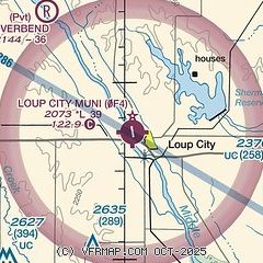
| Sectional chart |
|---|
|
| Airport distance calculator |
|---|
|
|
| Sunrise and sunset |
|---|
|
Times for 01-Aug-2026
| | Local
(UTC-5) | | Zulu
(UTC) |
|---|
| Morning civil twilight | | 06:01 | | 11:01 |
| Sunrise | | 06:32 | | 11:32 |
| Sunset | | 20:52 | | 01:52 |
| Evening civil twilight | | 21:23 | | 02:23 |
|
| Current date and time |
|---|
| Zulu (UTC) | 01-Aug-2026 05:47:48 |
|---|
| Local (UTC-5) | 01-Aug-2026 00:47:48 |
|---|
|
| METAR |
|---|
KODX
20nm N | 010453Z AUTO 36003KT 10SM CLR 19/19 A3011 RMK AO2 SLP188 T01940189 $
|
KBBW
31nm W | 010453Z AUTO 35005KT 10SM CLR 18/16 A3015 RMK AO2 SLP191 T01780161 $
|
KEAR
34nm S | 010456Z AUTO 33006KT 10SM CLR 21/17 A3012 RMK AO2 SLP183 T02060172
|
KGRI
36nm SE | 010453Z AUTO 35006KT 10SM CLR 19/17 A3011 RMK AO2 SLP186 T01890167
|
|
| TAF |
|---|
KEAR
34nm S | 311722Z 3118/0118 34020G30KT P6SM SCT025 FM010100 34012G18KT P6SM FEW030 FM010400 33007KT P6SM SKC FM011500 35012KT P6SM SKC
|
KGRI
36nm SE | 311721Z 3118/0118 34020G30KT P6SM SCT025 FM010100 34012G18KT P6SM FEW030 FM010400 33007KT P6SM SKC FM011500 35012KT P6SM SKC
|
|
| NOTAMs |
|---|
NOTAMs are issued by the DoD/FAA and will open in a separate window not controlled by AirNav.
|
|

