FAA INFORMATION EFFECTIVE 14 MAY 2026
Location
| FAA Identifier: | 0I8 |
| Lat/Long: | 38-21-58.1900N 084-17-00.0400W
38-21.969833N 084-17.000667W
38.3661639,-84.2833444
(estimated) |
| Elevation: | 720.9 ft. / 219.7 m (surveyed) |
| Variation: | 06W (2015) |
| From city: | 2 miles S of CYNTHIANA, KY |
| Time zone: | UTC -4 (UTC -5 during Standard Time) |
| Zip code: | 41031 |
Airport Operations
| Airport use: | Open to the public |
| Activation date: | 11/1961 |
| Control tower: | no |
| ARTCC: | INDIANAPOLIS CENTER |
| FSS: | LOUISVILLE FLIGHT SERVICE STATION |
| NOTAMs facility: | LOU (NOTAM-D service available) |
| Attendance: | 0800-DUSK |
| Wind indicator: | lighted |
| Segmented circle: | yes |
| Lights: | ACTVT REIL RWY 11 & 29; PAPI RWY 11 & 29; MIRL RWY 11/29 - CTAF. |
| Beacon: | white-green (lighted land airport)
Operates sunset to sunrise. |
Airport Communications
| CTAF/UNICOM: | 122.8 |
| LEXINGTON APPROACH: | 120.15 ;040-220 120.75 ;221-039 |
| LEXINGTON DEPARTURE: | 120.15 ;040-220 120.75 ;221-039 |
| WX AWOS-3 at 27K (11 nm SW): | 119.975 (502-867-1564) |
Nearby radio navigation aids
| VOR radial/distance | | VOR name | | Freq | | Var |
|---|
| FLMr180/17.0 | | FALMOUTH VOR/DME | | 117.00 | | 04W |
| HYKr020/25.6 | | LEXINGTON VOR/DME | | 112.60 | | 00E |
| FFTr072/(31.4) | | FRANKFORT VOR | | 109.40 | | 03W |
| NDB name | | Hdg/Dist | | Freq | | Var | | ID |
|---|
| SECO | | 345/38.4 | | 393 | | 03W | | XYC | -..- -.-- -.-. |
Airport Services
| Fuel available: | 100LL
100LL:FUEL AVBL 24/7 WITH CC. |
| Parking: | hangars and tiedowns |
| Airframe service: | MINOR |
| Powerplant service: | MINOR |
| Bottled oxygen: | NONE |
| Bulk oxygen: | NONE |
Runway Information
Runway 11/29
| Dimensions: | 3850 x 75 ft. / 1173 x 23 m |
| Surface: | asphalt, in good condition |
| Weight bearing capacity: | | Single wheel: | 16.0 | | Double wheel: | 25.0 |
|
| Runway edge lights: | medium intensity |
| RUNWAY 11 | | RUNWAY 29 |
| Latitude: | 38-22.054562N | | 38-21.884860N |
| Longitude: | 084-17.388890W | | 084-16.612538W |
| Elevation: | 720.9 ft. | | 720.0 ft. |
| Traffic pattern: | left | | left |
| Runway heading: | 112 magnetic, 106 true | | 292 magnetic, 286 true |
| Displaced threshold: | no | | 1094 ft. |
| Declared distances: | TORA:2757 TODA:3852 ASDA:3852 LDA:3852 | | TORA:3852 TODA:3852 ASDA:3852 LDA:2757 |
| Markings: | nonprecision, in fair condition | | nonprecision, in fair condition |
| Visual slope indicator: | 2-light PAPI on left (4.00 degrees glide path) | | 2-light PAPI on left (4.00 degrees glide path) |
| Runway end identifier lights: | yes | | yes |
| Touchdown point: | yes, no lights | | yes, no lights |
| Obstructions: | 36 ft. rr, 716 ft. from runway, 319 ft. right of centerline, 14:1 slope to clear | | 55 ft. trees, 5 ft. from runway, 211 ft. right of centerline, 1:1 slope to clear
+55 FT TREES 5 FT FM RWY END 211 FT R OF CNTRLN. |
Airport Ownership and Management from official FAA records
| Ownership: | Publicly-owned |
| Owner: | CYNTHIANA-HARRISON COUNTY ARPT BD
P.O. BOX 395
CYNTHIANA, KY 41031
Phone 859-234-5533 |
| Manager: | ROBERT CRAFT
40 AIRFIELD LANE
CYNTHIANA, KY 41031
Phone 859-234-8477 |
Additional Remarks
| - | FOR CD CTC LEXINGTON APCH AT 859-514-7890. |
Instrument Procedures
NOTE: All procedures below are presented as PDF files. If you need a reader for these files, you should download the free Adobe Reader.NOT FOR NAVIGATION. Please procure official charts for flight.
FAA instrument procedures published for use from 14 May 2026 at 0901Z to 11 June 2026 at 0900Z.
IAPs - Instrument Approach Procedures |
|---|
| RNAV (GPS) RWY 11 | |
download (180KB) |
| RNAV (GPS) RWY 29 | |
download (191KB) |
| NOTE: Special Take-Off Minimums/Departure Procedures apply | |
download |
Other nearby airports with instrument procedures:
27K - Georgetown-Scott County Regional Airport (11 nm SW)
K62 - Gene Snyder Airport (21 nm N)
KIOB - Mount Sterling/Montgomery County Airport (23 nm SE)
KLEX - Blue Grass Airport (25 nm SW)
KFGX - Fleming-Mason Airport (27 nm NE)
|
|

Road maps at:
MapQuest
Bing
Google
| Aerial photo |
|---|
WARNING: Photo may not be current or correct
 Photo by Russ Mintkenbaugh
Photo taken 17-Oct-2015
looking northwest.
Photo by Russ Mintkenbaugh
Photo taken 17-Oct-2015
looking northwest.
Do you have a better or more recent aerial photo of Cynthiana-Harrison County Airport that you would like to share? If so, please send us your photo.
|
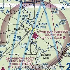
| Sectional chart |
|---|
|
| Airport distance calculator |
|---|
|
|
| Sunrise and sunset |
|---|
|
Times for 15-May-2026
| | Local
(UTC-4) | | Zulu
(UTC) |
|---|
| Morning civil twilight | | 05:57 | | 09:57 |
| Sunrise | | 06:27 | | 10:27 |
| Sunset | | 20:40 | | 00:40 |
| Evening civil twilight | | 21:10 | | 01:10 |
|
| Current date and time |
|---|
| Zulu (UTC) | 15-May-2026 19:25:42 |
|---|
| Local (UTC-4) | 15-May-2026 15:25:42 |
|---|
|
| METAR |
|---|
K27K
11nm SW | 151855Z AUTO 24005KT 10SM CLR 20/06 A3007 RMK AO2 T01970062
|
KK62
21nm N | 151855Z AUTO 17007KT 10SM SCT100 SCT120 21/05 A3007 RMK AO2
|
|
| TAF |
|---|
KIOB
23nm SE | 151722Z 1518/1618 VRB05KT P6SM SCT080 SCT300 FM161000 22008KT P6SM BKN130 PROB30 1613/1618 5SM -TSRA BKN040CB OVC130
|
KLEX
25nm SW | 151720Z 1518/1618 18007KT P6SM SCT100 FM160000 17004KT P6SM SCT250 FM161400 21014KT P6SM OVC050 PROB30 1615/1618 -SHRA OVC040
|
|
| NOTAMs |
|---|
NOTAMs are issued by the DoD/FAA and will open in a separate window not controlled by AirNav.
|
|

