FAA INFORMATION EFFECTIVE 30 OCTOBER 2025
Location
| FAA Identifier: | FGX |
| Lat/Long: | 38-32-29.7800N 083-44-38.4670W
38-32.496333N 083-44.641117W
38.5416056,-83.7440186
(estimated) |
| Elevation: | 913.3 ft. / 278.4 m (surveyed) |
| Variation: | 05W (2000) |
| From city: | 7 miles N of FLEMINGSBURG, KY |
| Time zone: | UTC -5 (UTC -4 during Daylight Saving Time) |
| Zip code: | 41056 |
Airport Operations
| Airport use: | Open to the public |
| Activation date: | 02/1972 |
| Control tower: | no |
| ARTCC: | INDIANAPOLIS CENTER |
| FSS: | LOUISVILLE FLIGHT SERVICE STATION |
| NOTAMs facility: | LOU (NOTAM-D service available) |
| Attendance: | MON-FRI 0800-1700, ALL SAT 1000-1600, ALL SUN 1100-1600
SVC AFT HR - 606-748-7170. |
| Wind indicator: | lighted |
| Segmented circle: | yes |
| Lights: | ACTVT REIL RWY 07 & 25; PAPI RWY 07 & 25; MIRL RWY 07/25 - CTAF. |
| Beacon: | white-green (lighted land airport)
Operates sunset to sunrise. |
Airport Communications
| CTAF/UNICOM: | 123.0 |
| WX AWOS-3: | 118.125 (606-742-2008) |
- APCH/DEP SVC PRVDD BY INDIANAPOLIS ARTCC ON FREQS 124.225/360.725 (PORTSMOUTH RCAG).
Nearby radio navigation aids
| VOR radial/distance | | VOR name | | Freq | | Var |
|---|
| FLMr108/27.3 | | FALMOUTH VOR/DME | | 117.00 | | 04W |
| NDB name | | Hdg/Dist | | Freq | | Var | | ID |
|---|
| SPORTYS | | 150/38.9 | | 245 | | 04W | | PWF | .--. .-- ..-. |
Airport Services
| Fuel available: | 100LL JET-A+ |
| Parking: | hangars and tiedowns |
| Airframe service: | MINOR |
| Powerplant service: | MINOR |
Runway Information
Runway 7/25
| Dimensions: | 5002 x 100 ft. / 1525 x 30 m |
| Surface: | asphalt, in good condition |
| Weight bearing capacity: | | PCN 22 /F/C/X/T | | Single wheel: | 58.5 | | Double wheel: | 79.0 |
|
| Runway edge lights: | medium intensity |
| Runway edge markings: | MARKINGS FADED. |
| RUNWAY 7 | | RUNWAY 25 |
| Latitude: | 38-32.336590N | | 38-32.656045N |
| Longitude: | 083-45.124725W | | 083-44.157475W |
| Elevation: | 905.0 ft. | | 910.7 ft. |
| Traffic pattern: | left | | left |
| Runway heading: | 072 magnetic, 067 true | | 252 magnetic, 247 true |
| Declared distances: | TORA:5002 TODA:5002 ASDA:5002 LDA:4703 | | TORA:5002 TODA:5002 ASDA:4703 LDA:4703 |
| Markings: | nonprecision, in poor condition | | nonprecision, in poor condition |
| Visual slope indicator: | 4-light PAPI on right (3.00 degrees glide path) | | 4-light PAPI on left (3.00 degrees glide path) |
| Runway end identifier lights: | yes | | yes |
| Touchdown point: | yes, no lights | | yes, no lights |
| Instrument approach: | | | LOCALIZER |
| Obstructions: | 19 ft. tree, 588 ft. from runway, 197 ft. left of centerline, 20:1 slope to clear | | 20 ft. tree, 299 ft. from runway, 153 ft. left of centerline, 4:1 slope to clear |
Airport Ownership and Management from official FAA records
| Ownership: | Publicly-owned |
| Owner: | FLEMING-MASON ARPT BOARD
PO BOX 460,, POB 460
MAYSVILLE, KY 41056
Phone (606) 407-2966
DAVID MAHER |
| Manager: | DERON MULLIKIN
7079 AIRPORT RD.
MAYSVILLE, KY 41056
Phone 606-742-2411
MANAGER'S CELL (606) 541-2957 |
Additional Remarks
| - | FOR CD CTC INDIANAPOLIS ARTCC AT 317-247-2411. |
Instrument Procedures
NOTE: All procedures below are presented as PDF files. If you need a reader for these files, you should download the free Adobe Reader.NOT FOR NAVIGATION. Please procure official charts for flight.
FAA instrument procedures published for use from 30 October 2025 at 0901Z to 27 November 2025 at 0900Z.
IAPs - Instrument Approach Procedures |
|---|
| RNAV (GPS) RWY 07 | |
download (237KB) |
| RNAV (GPS) RWY 25 | |
download (258KB) |
| VOR/DME-A | |
download (174KB) |
| NOTE: Special Alternate Minimums apply | |
download (27KB) |
| NOTE: Special Take-Off Minimums/Departure Procedures apply | |
download (372KB) |
Other nearby airports with instrument procedures:
KAMT - Alexander Salamon Airport (20 nm NE)
KSYM - Morehead-Rowan County Clyde A Thomas Regional Airport (21 nm S)
KGEO - Brown County Airport (21 nm N)
0I8 - Cynthiana-Harrison County Airport (27 nm W)
KIOB - Mount Sterling/Montgomery County Airport (31 nm S)
|
|

Road maps at:
MapQuest
Bing
Google
| Aerial photo |
|---|
WARNING: Photo may not be current or correct

Do you have a better or more recent aerial photo of Fleming-Mason Airport that you would like to share? If so, please send us your photo.
|
| Sectional chart |
|---|
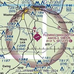
|
| Airport distance calculator |
|---|
|
|
| Sunrise and sunset |
|---|
|
Times for 09-Nov-2025
| | Local
(UTC-5) | | Zulu
(UTC) |
|---|
| Morning civil twilight | | 06:43 | | 11:43 |
| Sunrise | | 07:11 | | 12:11 |
| Sunset | | 17:26 | | 22:26 |
| Evening civil twilight | | 17:54 | | 22:54 |
|
| Current date and time |
|---|
| Zulu (UTC) | 09-Nov-2025 12:39:48 |
|---|
| Local (UTC-5) | 09-Nov-2025 07:39:48 |
|---|
|
| METAR |
|---|
| KFGX | 091215Z AUTO 25005KT 10SM BKN048 OVC085 09/08 A2975 RMK AO2 T00900084
|
|
| TAF |
|---|
KSYM
21nm S | 091139Z 0912/1012 25005KT P6SM SCT020 BKN040 TEMPO 0912/0914 4SM -SHRA BKN020 FM091400 24008KT P6SM SCT010 BKN025 FM091500 26010KT P6SM SCT007 BKN015 FM091900 27013G21KT P6SM SCT001 OVC007 PROB30 0919/0921 4SM -SHRA BKN005 FM092100 28012G21KT 2SM -SHRA SCT001 OVC003 FM100100 30010KT P6SM SCT001 OVC007 PROB30 1001/1007 4SM -SHRASN BKN001 BKN003
|
|
| NOTAMs |
|---|
NOTAMs are issued by the DoD/FAA and will open in a separate window not controlled by AirNav.
|
|

