FAA INFORMATION EFFECTIVE 19 FEBRUARY 2026
Location
| FAA Identifier: | 0Q9 |
| Lat/Long: | 38-15-26.9000N 122-26-04.4000W
38-15.448333N 122-26.073333W
38.2574722,-122.4345556
(estimated) |
| Elevation: | 28.5 ft. / 9 m (estimated) |
| Variation: | 16E (1985) |
| From city: | 3 miles SE of SONOMA, CA |
| Time zone: | UTC -8 (UTC -7 during Daylight Saving Time) |
| Zip code: | 95476 |
Airport Operations
| Airport use: | Open to the public |
| Activation date: | 01/1976 |
| Control tower: | no |
| ARTCC: | OAKLAND CENTER |
| FSS: | OAKLAND FLIGHT SERVICE STATION |
| NOTAMs facility: | OAK (NOTAM-D service available) |
| Attendance: | 0900-1700
OFC MAY BE CLSD WO NOTICE AT MGMT DISCRETION. |
| Wind indicator: | yes |
| Segmented circle: | yes |
Airport Communications
| CTAF/UNICOM: | 122.8 |
| WX ASOS at APC (8 nm E): | PHONE 707-252-7916 |
| WX AWOS-3P at O69 (8 nm W): | 132.325 (707-773-1529) |
| WX AWOS-3P at DVO (9 nm SW): | 120.675 (415-897-2236) |
Nearby radio navigation aids
| VOR radial/distance | | VOR name | | Freq | | Var |
|---|
| SGDr311/5.5 | | SCAGGS ISLAND VORTAC | | 112.10 | | 17E |
| CCRr288/22.4 | | CONCORD VOR/DME | | 117.00 | | 17E |
| PYEr045/23.1 | | POINT REYES VOR/DME | | 113.70 | | 17E |
| SAUr353/24.5 | | SAUSALITO VOR/DME | | 116.20 | | 17E |
| OAKr326/33.4 | | OAKLAND VOR/DME | | 116.80 | | 17E |
| SFOr339/38.4 | | SAN FRANCISCO VOR/DME | | 115.80 | | 17E |
Airport Services
| Fuel available: | 100LL |
| Parking: | tiedowns |
| Airframe service: | MINOR |
| Powerplant service: | MINOR |
| Bottled oxygen: | NONE |
| Bulk oxygen: | NONE |
Runway Information
Runway 8/26
| Dimensions: | 2490 x 40 ft. / 759 x 12 m |
| Surface: | asphalt, in fair condition |
| Weight bearing capacity: | |
| RUNWAY 8 | | RUNWAY 26 |
| Latitude: | 38-15.478167N | | 38-15.419633N |
| Longitude: | 122-26.331250W | | 122-25.816683W |
| Elevation: | 26.3 ft. | | 28.5 ft. |
| Traffic pattern: | right | | left |
| Markings: | basic, in good condition | | basic, in good condition |
| Runway end identifier lights: | no | | no |
| Obstructions: | 120 ft. trees, 1100 ft. from runway, 160 ft. left of centerline, 7:1 slope to clear
APCH RATIO TO DSPLCD THLD 22:1. | | 60 ft. trees, 234 ft. from runway, 150 ft. left of centerline
RWY 26, 15 FT BRUSH, 15 FT FM THLD, 0 - 125 FT RIGHT. 50 FT TREES 125 FT RIGHT AND LEFT. |
Airport Ownership and Management from official FAA records
| Ownership: | Privately-owned |
| Owner: | SONOMA SKYPARK, INC.
21870 8TH STREET EAST
SONOMA, CA 95476
Phone 707-996-2100 |
| Manager: | RON PRICE
21870 8TH STREET EAST
SONOMA, CA 95476
Phone 707-996-2100 |
Additional Remarks
| - | RWY 26 IS CALM WIND RWY. |
| - | NOISE SENSITIVE AREA EAST END OF RWY 08/26. 1000 FT MIN AGL OVER ALL PROPERTY IN IMT VCNTY OF THE ARPT. FOR NOISE ABATEMENT INFO CALL AMGR 707-996-2100. |
| - | ROTOR-WING, TBJT, ULTRALIGHTS PLUS ACFT OVER 8500 LBS GWT ARE PROHIBITED. NIGHT OPNS PROHIBITED. AMB, EMS ROTOR-WING ALLOWED 24HR DAILY. |
| - | RY 08 FOR ARR & DEP ONLY; NO TGL OR PRACTICE APCHS. |
| - | FOR CD CTC OAKLAND ARTCC AT 510-745-3380. |
| - | EARLY MORNING OPN OF HOT AIR BLNS. |
| - | NGTLY TIE-DOWN FEE. |
Instrument Procedures
There are no published instrument procedures at 0Q9.
Some nearby airports with instrument procedures:
KAPC - Napa County Airport (8 nm E)
O69 - Petaluma Municipal Airport (8 nm W)
KDVO - Gnoss Field Airport (9 nm SW)
CA35 - San Rafael Airport (15 nm S)
KSTS - Charles M Schulz/Sonoma County Airport (23 nm NW)
|
|

Road maps at:
MapQuest
Bing
Google
| Aerial photo |
|---|
WARNING: Photo may not be current or correct
 Photo by Frank Schmidt
Photo taken 05-Aug-2011
looking northeast.
Photo by Frank Schmidt
Photo taken 05-Aug-2011
looking northeast.
Do you have a better or more recent aerial photo of Sonoma Skypark Airport that you would like to share? If so, please send us your photo.
|
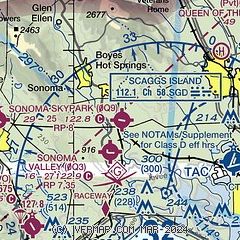
| Sectional chart |
|---|
|
| Airport distance calculator |
|---|
|
|
| Sunrise and sunset |
|---|
|
Times for 19-Feb-2026
| | Local
(UTC-8) | | Zulu
(UTC) |
|---|
| Morning civil twilight | | 06:29 | | 14:29 |
| Sunrise | | 06:56 | | 14:56 |
| Sunset | | 17:51 | | 01:51 |
| Evening civil twilight | | 18:18 | | 02:18 |
|
| Current date and time |
|---|
| Zulu (UTC) | 20-Feb-2026 07:13:45 |
|---|
| Local (UTC-8) | 19-Feb-2026 23:13:45 |
|---|
|
| METAR |
|---|
KAPC
8nm SE | 200654Z AUTO 34005KT 10SM CLR 03/01 A2992 RMK AO2 SLP124 T00280011
|
KO69
8nm W | 200655Z AUTO 29005KT 10SM CLR 03/02 A2994 RMK A01
|
KDVO
9nm SW | 200655Z AUTO 30008G14KT 250V320 10SM CLR 08/01 A2992 RMK AO2
|
|
| TAF |
|---|
KAPC
8nm SE | 200532Z 2006/2106 28010KT P6SM SCT050 BKN080 FM200900 VRB03KT P6SM FEW050 BKN200 FM201900 20007KT P6SM BKN200 FM210200 VRB04KT P6SM SCT050 BKN200
|
|
| NOTAMs |
|---|
NOTAMs are issued by the DoD/FAA and will open in a separate window not controlled by AirNav.
|
|

