FAA INFORMATION EFFECTIVE 19 FEBRUARY 2026
Location
| FAA Identifier: | 16J |
| Lat/Long: | 31-44-35.8370N 084-25-09.4490W
31-44.597283N 084-25.157483W
31.7432881,-84.4192914
(estimated) |
| Elevation: | 332.2 ft. / 101.3 m (surveyed) |
| Variation: | 02W (1995) |
| From city: | 2 miles SE of DAWSON, GA |
| Time zone: | UTC -5 (UTC -4 during Daylight Saving Time) |
| Zip code: | 31742 |
Airport Operations
| Airport use: | Open to the public |
| Activation date: | 02/1947 |
| Control tower: | no |
| ARTCC: | JACKSONVILLE CENTER |
| FSS: | MACON FLIGHT SERVICE STATION |
| NOTAMs facility: | MCN (NOTAM-D service available) |
| Attendance: | MON-SAT 0800-1700, ALL SUN 1300-1700 |
| Wind indicator: | lighted |
| Segmented circle: | yes |
| Lights: | PAPI RWY 14 & 32 OPER CONSLY. MIRL RWY 14/32 PRESET MED INTST DUSK-2200, AFT 2200 ACTVT - CTAF. |
| Beacon: | white-green (lighted land airport)
Operates sunset to sunrise. |
Airport Communications
| CTAF/UNICOM: | 123.05 |
| WX AWOS-3PT: | 118.800 (229-222-5289) |
| WX ASOS at ABY (17 nm SE): | PHONE 229-434-7494 |
- APCH/DEP SVC PRVDD BY JACKSONVILLE ARTCC ON FREQS 125.75/363.075 (ALBANY RCAG).
Nearby radio navigation aids
| VOR radial/distance | | VOR name | | Freq | | Var |
|---|
| PZDr311/8.3 | | PECAN VOR/DME | | 116.10 | | 02W |
| EUFr107/38.3 | | EUFAULA VOR/DME | | 109.20 | | 02E |
| NDB name | | Hdg/Dist | | Freq | | Var | | ID |
|---|
| LINDBERGH | | 215/30.3 | | 242 | | 04W | | LKG | .-.. -.- --. |
| CONEY | | 248/32.3 | | 400 | | 06W | | OHY | --- .... -.-- |
Airport Services
| Fuel available: | 100LL JET-A
A:JET-A AVAILABLE WITH CALLOUT. CALL 229-995-3787 |
| Parking: | tiedowns |
| Airframe service: | NONE |
| Powerplant service: | NONE |
| Bottled oxygen: | NONE |
| Bulk oxygen: | NONE |
Runway Information
Runway 14/32
| Dimensions: | 4507 x 75 ft. / 1374 x 23 m |
| Surface: | asphalt, in fair condition |
| Weight bearing capacity: | |
| Runway edge lights: | medium intensity |
| RUNWAY 14 | | RUNWAY 32 |
| Latitude: | 31-44.845223N | | 31-44.349345N |
| Longitude: | 084-25.481418W | | 084-24.833563W |
| Elevation: | 332.2 ft. | | 288.8 ft. |
| Traffic pattern: | left | | left |
| Runway heading: | 134 magnetic, 132 true | | 314 magnetic, 312 true |
| Markings: | nonprecision, in fair condition | | nonprecision, in fair condition |
| Visual slope indicator: | 2-light PAPI on left (3.00 degrees glide path) | | 2-light PAPI on left (3.00 degrees glide path) |
| Touchdown point: | yes, no lights | | yes, no lights |
| Obstructions: | 22 ft. trees, 574 ft. from runway, 242 ft. left of centerline, 17:1 slope to clear | | 31 ft. trees, 510 ft. from runway, 231 ft. left of centerline, 10:1 slope to clear |
Airport Ownership and Management from official FAA records
| Ownership: | Publicly-owned |
| Owner: | TERRELL COUNTY AIRPORT AUTHORITY
2678 ALBANY HWY
DAWSON, GA 39842
Phone 229-995-3787 |
| Manager: | ANN GARNER
2678 ALBANY HWY
DAWSON, GA 39842
Phone 229-995-3787 |
Additional Remarks
| - | DEER ON & INVOF ARPT. |
| - | FOR CD CTC JACKSONVILLE ARTCC AT 904-845-1592. |
| - | BIRDS INVOF ARPT |
Instrument Procedures
NOTE: All procedures below are presented as PDF files. If you need a reader for these files, you should download the free Adobe Reader.NOT FOR NAVIGATION. Please procure official charts for flight.
FAA instrument procedures published for use from 19 February 2026 at 0901Z to 19 March 2026 at 0900Z.
IAPs - Instrument Approach Procedures |
|---|
| RNAV (GPS) RWY 32 | |
download (189KB) |
| NOTE: Special Take-Off Minimums/Departure Procedures apply | |
download (597KB) |
Other nearby airports with instrument procedures:
KABY - Southwest Georgia Regional Airport (17 nm SE)
KACJ - Jimmy Carter Regional Airport (25 nm NE)
KBIJ - Early County Airport (32 nm SW)
KCXU - Camilla-Mitchell County Airport (33 nm S)
KCKF - Crisp County-Cordele Airport (36 nm NE)
|
|

Road maps at:
MapQuest
Bing
Google
| Aerial photo |
|---|
WARNING: Photo may not be current or correct
 Photo by Steve Williams
Photo taken 04-Jul-2008
Photo by Steve Williams
Photo taken 04-Jul-2008
Do you have a better or more recent aerial photo of Dawson Municipal Airport that you would like to share? If so, please send us your photo.
|
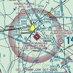
| Sectional chart |
|---|
|
| Airport distance calculator |
|---|
|
|
| Sunrise and sunset |
|---|
|
Times for 12-Mar-2026
| | Local
(UTC-4) | | Zulu
(UTC) |
|---|
| Morning civil twilight | | 07:28 | | 11:28 |
| Sunrise | | 07:53 | | 11:53 |
| Sunset | | 19:42 | | 23:42 |
| Evening civil twilight | | 20:07 | | 00:07 |
|
| Current date and time |
|---|
| Zulu (UTC) | 13-Mar-2026 00:43:08 |
|---|
| Local (UTC-4) | 12-Mar-2026 20:43:08 |
|---|
|
| METAR |
|---|
KABY
17nm SE | 122353Z AUTO 01006KT 10SM CLR 14/M02 A3012 RMK AO2 SLP197 T01441017 10194 20144 53019
|
KACJ
25nm NE | 130015Z AUTO VRB05KT 10SM CLR 12/M03 A3009 RMK AO2 T01201029
|
KBIJ
32nm SW | 130015Z AUTO 00000KT 10SM CLR 13/01 A3012 RMK AO2
|
KCXU
33nm S | 130015Z AUTO 36005KT 10SM CLR 14/00 A3010 RMK AO2
|
|
| TAF |
|---|
KABY
17nm SE | 121735Z 1218/1318 33015G26KT P6SM BKN016 FM122000 34014G25KT P6SM SCT050 SCT200 FM130000 36009KT P6SM SKC FM130300 02005KT P6SM SKC
|
|
| NOTAMs |
|---|
NOTAMs are issued by the DoD/FAA and will open in a separate window not controlled by AirNav.
|
|


