FAA INFORMATION EFFECTIVE 19 FEBRUARY 2026
Location
| FAA Identifier: | 1G0 |
| Lat/Long: | 41-23-27.6000N 083-37-48.5000W
41-23.460000N 083-37.808333W
41.3910000,-83.6301389
(estimated) |
| Elevation: | 673 ft. / 205.1 m (surveyed) |
| Variation: | 05W (1985) |
| From city: | 1 mile NE of BOWLING GREEN, OH |
| Time zone: | UTC -5 (UTC -4 during Daylight Saving Time) |
| Zip code: | 43402 |
Airport Operations
| Airport use: | Open to the public |
| Activation date: | 06/1944 |
| Control tower: | no |
| ARTCC: | CLEVELAND CENTER |
| FSS: | CLEVELAND FLIGHT SERVICE STATION |
| NOTAMs facility: | CLE (NOTAM-D service available) |
| Attendance: | MON-SAT 0800-1700, ALL SUN 0800-1600 |
| Pattern altitude: | 1700 ft. MSL |
| Wind indicator: | lighted |
| Segmented circle: | yes |
| Lights: | ACTVT MIRL RWYS 10/28 & 18/36; REIL RWY 10, 18 & 28 PAPI RWY 18 - CTAF. |
| Beacon: | white-green (lighted land airport)
Operates sunset to sunrise. |
Airport Communications
| CTAF/UNICOM: | 122.975 |
| WX AWOS-3: | 120.725 (419-354-1415) |
| TOLEDO APPROACH: | 126.1 |
| TOLEDO DEPARTURE: | 126.1 |
| CLEARANCE DELIVERY: | 125.6 |
| WX ASOS at TDZ (12 nm NE): | 121.575 (419-838-5034) |
| WX ASOS at TOL (14 nm NW): | PHONE 419-210-1094 |
| WX AWOS-3 at FZI (16 nm SE): | 124.625 (419-436-0053) |
Nearby radio navigation aids
| VOR radial/distance | | VOR name | | Freq | | Var |
|---|
| FBCr014/26.8 | | FLAG CITY VORTAC | | 108.20 | | 02W |
| NDB name | | Hdg/Dist | | Freq | | Var | | ID |
|---|
| TIFFIN | | 319/25.8 | | 269 | | 05W | | TII | - .. .. |
| ADRIAN | | 151/35.0 | | 278 | | 06W | | ADG | .- -.. --. |
Airport Services
| Fuel available: | 100LL JET-A
A:ANTI-ICING AVBL AT NOZZLE. |
| Parking: | hangars and tiedowns |
Runway Information
Runway 10/28
| Dimensions: | 4199 x 75 ft. / 1280 x 23 m |
| Surface: | asphalt, in good condition |
| Runway edge lights: | medium intensity |
| RUNWAY 10 | | RUNWAY 28 |
| Latitude: | 41-23.507455N | | 41-23.497500N |
| Longitude: | 083-38.113402W | | 083-37.195282W |
| Elevation: | 671.5 ft. | | 671.6 ft. |
| Traffic pattern: | left | | right |
| Runway heading: | 096 magnetic, 091 true | | 276 magnetic, 271 true |
| Markings: | nonprecision, in good condition | | nonprecision, in good condition |
| Visual slope indicator: | 2-light PAPI on left (3.00 degrees glide path) | | 2-light PAPI on left (3.00 degrees glide path) |
| Runway end identifier lights: | yes | | yes |
| Touchdown point: | yes, no lights | | yes, no lights |
| Obstructions: | 3 ft. crops, 201 ft. from runway, 165 ft. left and right of centerline
OBSTN CLNC SLP 0:1 DUE TO +3 FT CROPS/CULTIVATED FLD, 75-200 FT DIST, 165 FT R. | | 3 ft. crops, 201 ft. from runway, 150 ft. left and right of centerline
OBSTN CLNC SLP 0:1 DUE TO +3 FT CROPS/CULTIVATED FLD, 0-200 FT DIST, 150 FT R; 145-200 FT DIST, 150 FT R. |
Runway 18/36
| Dimensions: | 2628 x 50 ft. / 801 x 15 m |
| Surface: | asphalt, in good condition |
| Runway edge lights: | medium intensity |
| RUNWAY 18 | | RUNWAY 36 |
| Latitude: | 41-23.606173N | | 41-23.173455N |
| Longitude: | 083-38.057833W | | 083-38.052310W |
| Elevation: | 671.4 ft. | | 671.4 ft. |
| Traffic pattern: | left | | right |
| Runway heading: | 184 magnetic, 179 true | | 004 magnetic, 359 true |
| Displaced threshold: | no | | 68 ft. |
| Markings: | nonprecision, in good condition | | nonprecision, in good condition |
| Visual slope indicator: | 4-light PAPI on left (3.00 degrees glide path) | | |
| Runway end identifier lights: | yes | | no |
| Touchdown point: | yes, no lights | | yes, no lights |
| Obstructions: | 3 ft. crops, 201 ft. from runway, 140 ft. left and right of centerline
OBSTN CLNC SLP 0:1 DUE TO +3 FT CROPS/CULTIVATED FLD, 0-200 FT DIST, 140 FT L & 150 FT R. | | 16 ft. road, 270 ft. from runway, 260 ft. left and right of centerline, 4:1 slope to clear
OBSTN CLNC SLP 0:1 DUE TO +3 FT CROPS/CULTIVATED FLD, 0-200 FT DIST, 140 FT R. |
Airport Ownership and Management from official FAA records
| Ownership: | Publicly-owned |
| Owner: | WOOD CO ARPT AUTH
1261 E POE RD
BOWLING GREEN, OH 43402-9392
Phone 419-354-2908 |
| Manager: | PATRICK OREM
1261 E POE RD
BOWLING GREEN, OH 43402-9392
Phone 419-354-2908
OR 419-654-6623. |
Additional Remarks
| A30A-28 | CALM WIND RWY. |
| - | OCCNL BIRDS AND OTHER WILDLIFE ON & INVOF ARPT |
| - | 160 FT AGL STADIUM LGTS .6 NM SE OF ARPT. |
| - | FOR CD CTC TOLEDO APCH AT 419-865-1495 |
Instrument Procedures
NOTE: All procedures below are presented as PDF files. If you need a reader for these files, you should download the free Adobe Reader.NOT FOR NAVIGATION. Please procure official charts for flight.
FAA instrument procedures published for use from 19 February 2026 at 0901Z to 19 March 2026 at 0900Z.
IAPs - Instrument Approach Procedures |
|---|
| RNAV (GPS) RWY 10 | |
download (221KB) |
| RNAV (GPS) RWY 18 | |
download (195KB) |
| RNAV (GPS) RWY 28 | |
download (229KB) |
| RNAV (GPS) RWY 36 | |
download (181KB) |
| NOTE: Special Take-Off Minimums/Departure Procedures apply | |
download (164KB) |
Other nearby airports with instrument procedures:
KTDZ - Toledo Executive Airport (12 nm NE)
KTOL - Eugene F Kranz Toledo Express Airport (14 nm NW)
KFZI - Donald P Miller Airport (16 nm SE)
7W5 - Henry County Airport (20 nm W)
KDUH - Toledo Suburban Airport (21 nm N)
|
|

Road maps at:
MapQuest
Bing
Google
| Aerial photo |
|---|
WARNING: Photo may not be current or correct
 Photo by Matt McVicker
Taken in November 2011
looking east.
Photo by Matt McVicker
Taken in November 2011
looking east.
Do you have a better or more recent aerial photo of Wood County Airport that you would like to share? If so, please send us your photo.
|
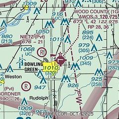
| Sectional chart |
|---|
|
CAUTION: Diagram may not be current

| Airport distance calculator |
|---|
|
|
| Sunrise and sunset |
|---|
|
Times for 04-Mar-2026
| | Local
(UTC-5) | | Zulu
(UTC) |
|---|
| Morning civil twilight | | 06:38 | | 11:38 |
| Sunrise | | 07:05 | | 12:05 |
| Sunset | | 18:27 | | 23:27 |
| Evening civil twilight | | 18:55 | | 23:55 |
|
| Current date and time |
|---|
| Zulu (UTC) | 04-Mar-2026 16:13:22 |
|---|
| Local (UTC-5) | 04-Mar-2026 11:13:22 |
|---|
|
| METAR |
|---|
KTDZ
12nm NE | 041604Z AUTO 07007KT 4SM BR OVC003 02/01 A3026 RMK AO2 T00170011
|
KTOL
14nm NW | 041559Z 09006KT 3SM BR OVC003 02/01 A3025 RMK AO2 T00170006
|
KDUH
21nm N | 041555Z AUTO 11007KT 2 1/2SM BR OVC001 01/01 A3025 RMK AO2 VIS 2V3
|
KFDY
23nm S | 041553Z AUTO 08008KT 7SM OVC006 05/03 A3021 RMK AO2 SLP233 T00500033
|
|
| TAF |
|---|
KTOL
14nm NW | 041123Z 0412/0512 06004KT 1SM BR OVC002 FM041900 08005KT 5SM BR OVC008 FM050100 08004KT 1SM BR OVC004 FM050400 06003KT 3/4SM -SHRA BR OVC003
|
|
| NOTAMs |
|---|
NOTAMs are issued by the DoD/FAA and will open in a separate window not controlled by AirNav.
|
|


