FAA INFORMATION EFFECTIVE 30 OCTOBER 2025
Location
| FAA Identifier: | 7W5 |
| Lat/Long: | 41-22-27.3710N 084-04-04.3650W
41-22.456183N 084-04.072750W
41.3742697,-84.0678792
(estimated) |
| Elevation: | 682.9 ft. / 208.1 m (surveyed) |
| Variation: | 05W (1985) |
| From city: | 3 miles E of NAPOLEON, OH |
| Time zone: | UTC -5 (UTC -4 during Daylight Saving Time) |
| Zip code: | 43545 |
Airport Operations
| Airport use: | Open to the public |
| Activation date: | 11/1971 |
| Control tower: | no |
| ARTCC: | CLEVELAND CENTER |
| FSS: | CLEVELAND FLIGHT SERVICE STATION |
| NOTAMs facility: | CLE (NOTAM-D service available) |
| Attendance: | MON-FRI 0800-1730, ALL SAT-SUN ON CALL
FOR SVC CALL AMGR CELL. |
| Wind indicator: | lighted |
| Segmented circle: | no |
| Lights: | ACTVT REIL RWY 10 & 28; PAPI RWY 10 & 28; MIRL RWY 10/28 - CTAF. |
| Beacon: | white-green (lighted land airport)
Operates sunset to sunrise. |
Airport Communications
| CTAF/UNICOM: | 123.0 |
| TOLEDO APPROACH: | 134.35 |
| TOLEDO DEPARTURE: | 134.35 |
| WX AWOS-3P at USE (14 nm N): | 127.375 (419-335-0775) |
| WX ASOS at DFI (16 nm W): | 121.425 (419-658-2301) |
| WX ASOS at TOL (17 nm NE): | PHONE 419-210-1094 |
| WX AWOS-3 at 1G0 (20 nm E): | 120.725 (419-354-1415) |
Nearby radio navigation aids
| VOR radial/distance | | VOR name | | Freq | | Var |
|---|
| FBCr333/28.8 | | FLAG CITY VORTAC | | 108.20 | | 02W |
| NDB name | | Hdg/Dist | | Freq | | Var | | ID |
|---|
| TOPHR | | 217/12.6 | | 219 | | 05W | | TO | - --- |
| ADRIAN | | 185/29.7 | | 278 | | 06W | | ADG | .- -.. --. |
Airport Services
| Fuel available: | 100LL JET-A |
| Parking: | hangars and tiedowns |
| Airframe service: | MAJOR |
| Powerplant service: | MAJOR |
| Bottled oxygen: | LOW |
| Bulk oxygen: | NONE |
Runway Information
Runway 10/28
| Dimensions: | 4001 x 60 ft. / 1220 x 18 m |
| Surface: | asphalt, in excellent condition |
| Runway edge lights: | medium intensity |
| RUNWAY 10 | | RUNWAY 28 |
| Latitude: | 41-22.517658N | | 41-22.394668N |
| Longitude: | 084-04.502347W | | 084-03.643177W |
| Elevation: | 680.8 ft. | | 682.8 ft. |
| Traffic pattern: | left | | left |
| Runway heading: | 106 magnetic, 101 true | | 286 magnetic, 281 true |
| Markings: | nonprecision, in good condition | | nonprecision, in good condition |
| Visual slope indicator: | 2-light PAPI on left (3.00 degrees glide path) | | 2-light PAPI on left (3.00 degrees glide path) |
| Runway end identifier lights: | yes | | yes |
| Touchdown point: | yes, no lights | | yes, no lights |
| Obstructions: | 5 ft. crops, 200 ft. from runway, 95 ft. right of centerline
+5 FT CROPS/CULTIVATED FLD, 140-200 FT DIST, 95-125 FT R. | | 6 ft. crops, 200 ft. from runway, 125 ft. left of centerline
+6 FT CROPS/CULTIVATED FLD, 0-200 FT DIST, 125 FT L TO 130 FT R. |
Airport Ownership and Management from official FAA records
| Ownership: | Publicly-owned |
| Owner: | HENRY CO ARPT AUTH
10646 COUNTY ROAD O
NAPOLEON, OH 43545-6217
Phone 419-599-6494 |
| Manager: | JARED AMES, ACTING AMGR
10646 COUNTY ROAD O
NAPOLEON, OH 43545-6217
Phone 419-599-6494
CELL 419-388-9259. |
Additional Remarks
| - | FOR CD CTC TOLEDO APCH AT 419-865-1495. |
Instrument Procedures
NOTE: All procedures below are presented as PDF files. If you need a reader for these files, you should download the free Adobe Reader.NOT FOR NAVIGATION. Please procure official charts for flight.
FAA instrument procedures published for use from 30 October 2025 at 0901Z to 27 November 2025 at 0900Z.
IAPs - Instrument Approach Procedures |
|---|
| RNAV (GPS) RWY 28 | |
download (190KB) |
| NOTE: Special Take-Off Minimums/Departure Procedures apply | |
download (487KB) |
Other nearby airports with instrument procedures:
KUSE - Fulton County Airport (14 nm N)
KDFI - Defiance Memorial Airport (16 nm W)
KTOL - Eugene F Kranz Toledo Express Airport (17 nm NE)
1G0 - Wood County Airport (20 nm E)
0G6 - Williams County Airport (21 nm W)
|
|

Road maps at:
MapQuest
Bing
Google
| Aerial photo |
|---|
WARNING: Photo may not be current or correct
 Photo by Roger Kellogg
Photo taken 29-Sep-2007
Photo by Roger Kellogg
Photo taken 29-Sep-2007
Do you have a better or more recent aerial photo of Henry County Airport that you would like to share? If so, please send us your photo.
|
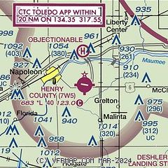
| Sectional chart |
|---|
|
CAUTION: Diagram may not be current

| Airport distance calculator |
|---|
|
|
| Sunrise and sunset |
|---|
|
Times for 27-Nov-2025
| | Local
(UTC-5) | | Zulu
(UTC) |
|---|
| Morning civil twilight | | 07:09 | | 12:09 |
| Sunrise | | 07:40 | | 12:40 |
| Sunset | | 17:08 | | 22:08 |
| Evening civil twilight | | 17:39 | | 22:39 |
|
| Current date and time |
|---|
| Zulu (UTC) | 27-Nov-2025 07:24:43 |
|---|
| Local (UTC-5) | 27-Nov-2025 02:24:43 |
|---|
|
| METAR |
|---|
KUSE
14nm N | 270655Z AUTO 25019KT 2 1/2SM -SN FEW003 BKN015 OVC065 M01/M02 A2995 RMK AO2
|
KDFI
17nm W | 270653Z AUTO 25009G20KT 9SM -SN OVC041 M01/M06 A3000 RMK AO2 PK WND 26028/0616 SLP166 P0000 T10061056
|
KTOL
17nm NE | 270652Z 23018G26KT 4SM -SN BR SCT014 OVC026 M01/M03 A2996 RMK AO2 PK WND 24031/0600 SLP153 P0001 T10111033
|
KOWX
21nm S | 270647Z 25019G28KT 10SM FEW027 FEW032 OVC050 M00/M05 A3003 RMK AO1
|
KFDY
28nm SE | 270653Z AUTO 25017G26KT 10SM SCT033 SCT055 M01/M06 A3000 RMK AO2 PK WND 25029/0600 SLP164 T10111061
|
KDUH
29nm NE | 270655Z AUTO 25014G26KT 10SM -SN SCT013 BKN019 BKN070 M01/M04 A2994 RMK AO2 PK WND 24026/50
|
KTDZ
29nm NE | 270653Z AUTO 23017G31KT 7SM -SN OVC024 M01/M04 A2997 RMK AO2 PK WND 23032/0637 SLP153 P0000 T10111044 $
|
|
| TAF |
|---|
KTOL
17nm NE | 270532Z 2706/2806 26017G32KT P6SM VCSH OVC035 FM271300 27017G32KT P6SM VCSH BKN025 FM271700 26020G28KT P6SM BKN040 FM280400 28012G20KT P6SM SCT050
|
|
| NOTAMs |
|---|
NOTAMs are issued by the DoD/FAA and will open in a separate window not controlled by AirNav.
|
|


