FAA INFORMATION EFFECTIVE 09 JULY 2026
Location
| FAA Identifier: | 1MO |
| Lat/Long: | 37-07-15.1011N 092-18-36.3840W
37-07.251685N 092-18.606400W
37.1208614,-92.3101067
(estimated) |
| Elevation: | 1476.4 ft. / 450.0 m (surveyed) |
| Variation: | 01E (2010) |
| From city: | 3 miles SW of MOUNTAIN GROVE, MO |
| Time zone: | UTC -5 (UTC -6 during Standard Time) |
| Zip code: | 65711 |
Airport Operations
| Airport use: | Open to the public |
| Control tower: | no |
| ARTCC: | KANSAS CITY CENTER |
| FSS: | COLUMBIA FLIGHT SERVICE STATION |
| NOTAMs facility: | COU (NOTAM-D service available) |
| Attendance: | CONTINUOUS |
| Wind indicator: | lighted |
| Segmented circle: | yes |
| Lights: | ACTVT REIL RWY 08 & 26; MIRL RWY 08/26 - CTAF. |
| Beacon: | white-green (lighted land airport)
ROTG BCN ON WATER TOWER EAST OF ARPT. Operates sunset to sunrise. |
Airport Communications
- APCH/DEP SVC PRVDD BY KANSAS CITY ARTCC ON FREQS 128.35/284.675 (RICHLAND RCAG).
Nearby radio navigation aids
| VOR radial/distance | | VOR name | | Freq | | Var |
|---|
| DGDr077/27.8 | | DOGWOOD VORTAC | | 109.40 | | 01E |
| TBNr192/(38.2) | | FORNEY VOR | | 110.00 | | 00E |
Airport Services
| Fuel available: | 100LL |
| Parking: | tiedowns |
| Airframe service: | NONE |
| Powerplant service: | NONE |
Runway Information
Runway 8/26
| Dimensions: | 2922 x 60 ft. / 891 x 18 m |
| Surface: | asphalt/rubberized friction seal coat, in excellent condition |
| Runway edge lights: | medium intensity |
| RUNWAY 8 | | RUNWAY 26 |
| Latitude: | 37-07.214888N | | 37-07.288480N |
| Longitude: | 092-18.903510W | | 092-18.309288W |
| Elevation: | 1452.2 ft. | | 1476.2 ft. |
| Traffic pattern: | left | | left |
| Runway heading: | 080 magnetic, 081 true | | 260 magnetic, 261 true |
| Markings: | nonprecision, in good condition | | nonprecision, in good condition |
| Visual slope indicator: | 2-light PAPI on left (4.00 degrees glide path) | | 2-light PAPI on left (4.00 degrees glide path) |
| Runway end identifier lights: | yes | | yes |
| Touchdown point: | yes, no lights | | yes, no lights |
| Obstructions: | 51 ft. trees, 307 ft. from runway, 150 ft. right of centerline, 2:1 slope to clear
RWY 8 HAS 18-54 FT TREES 0-200 FT FROM RWY END 150-228 FT RIGHT AND 195-200 FT LEFT. | | 15 ft. road, 285 ft. from runway, 250 ft. left and right of centerline, 5:1 slope to clear |
Airport Ownership and Management from official FAA records
| Ownership: | Publicly-owned |
| Owner: | CITY OF MOUNTAIN GROVE
100 E. STATE, P.O. BOX 351
MOUNTAIN GROVE, MO 65711
Phone 417-926-4162 |
| Manager: | DAVID RICHARDSON
100 E. STATE STREET
MOUNTAIN GROVE, MO 65711
Phone (417) 926-4162 |
Additional Remarks
| A96 | ULTRALIGHT ACTVTY ON & INVOF ARPT. |
| - | CROP DUSTING ACFT ON & INVOF ARPT. |
| - | FOR CD CTC KANSAS CITY ARTCC AT 913-254-8508. |
Instrument Procedures
NOTE: All procedures below are presented as PDF files. If you need a reader for these files, you should download the free Adobe Reader.NOT FOR NAVIGATION. Please procure official charts for flight.
FAA instrument procedures published for use from 09 July 2026 at 0901Z to 06 August 2026 at 0900Z.
IAPs - Instrument Approach Procedures |
|---|
| RNAV (GPS) RWY 08 | |
download (183KB) |
| RNAV (GPS) RWY 26 | |
download (183KB) |
| NOTE: Special Take-Off Minimums/Departure Procedures apply | |
download (421KB) |
Other nearby airports with instrument procedures:
KTVB - Cabool Memorial Airport (11 nm E)
KAOV - Ava Bill Martin Memorial Airport (20 nm SW)
M48 - Houston Memorial Airport (20 nm NE)
KUNO - West Plains Regional Airport (24 nm SE)
KMNF - Mountain View Airport (30 nm E)
|
|

Road maps at:
MapQuest
Bing
Google
| Aerial photo |
|---|
WARNING: Photo may not be current or correct
 Photo taken 06-Jan-2013
looking west southwest.
Photo taken 06-Jan-2013
looking west southwest.
Do you have a better or more recent aerial photo of Mountain Grove Memorial Airport that you would like to share? If so, please send us your photo.
|
| Sectional chart |
|---|
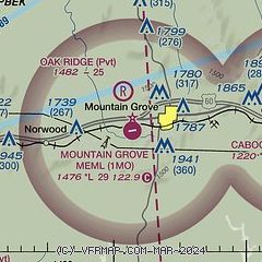
|
| Airport distance calculator |
|---|
|
|
| Sunrise and sunset |
|---|
|
Times for 13-Jul-2026
| | Local
(UTC-5) | | Zulu
(UTC) |
|---|
| Morning civil twilight | | 05:31 | | 10:31 |
| Sunrise | | 06:01 | | 11:01 |
| Sunset | | 20:29 | | 01:29 |
| Evening civil twilight | | 20:59 | | 01:59 |
|
| Current date and time |
|---|
| Zulu (UTC) | 13-Jul-2026 19:38:52 |
|---|
| Local (UTC-5) | 13-Jul-2026 14:38:52 |
|---|
|
| METAR |
|---|
KUNO
24nm SE | 131853Z AUTO 04008KT 10SM CLR 29/20 A3019 RMK AO2 SLP210 T02940200
|
KLBO
36nm NW | 131915Z AUTO 03008KT 10SM SCT047 29/18 A3021 RMK AO2
|
KTBN
37nm N | 131855Z 04009KT 10SM BKN048 29/19 A3017 RMK AO2A SLP209 T02940185
|
KBPK
46nm S | 131853Z AUTO VRB03KT 10SM BKN055 31/20 A3016 RMK AO2 SLP201 T03060200
|
|
| TAF |
|---|
KTBN
37nm N | 131300Z 1313/1419 01006KT 9000 BR FEW030 QNH3016INS BECMG 1314/1316 05010KT 9999 NSW SCT040 QNH3013INS BECMG 1323/1401 03006KT 9999 FEW250 QNH3010INS TX30/1321Z TN18/1411Z LAST NO AMDS AFT 1322 NEXT 1413
|
KBPK
46nm S | 131720Z 1318/1418 08006KT P6SM SCT025 BKN050 FM140100 VRB04KT P6SM SKC FM141400 04006KT P6SM SCT050
|
|
| NOTAMs |
|---|
NOTAMs are issued by the DoD/FAA and will open in a separate window not controlled by AirNav.
|
|

