FAA INFORMATION EFFECTIVE 25 DECEMBER 2025
Location
| FAA Identifier: | 1R4 |
| Lat/Long: | 31-07-34.8700N 092-30-04.6400W
31-07.581167N 092-30.077333W
31.1263528,-92.5012889
(estimated) |
| Elevation: | 140 ft. / 43 m (estimated) |
| Variation: | 00W (2020) |
| From city: | 2 miles S of WOODWORTH, LA |
| Time zone: | UTC -6 (UTC -5 during Daylight Saving Time) |
| Zip code: | 71430 |
Airport Operations
| Airport use: | Open to the public |
| Activation date: | 01/1960 |
| Control tower: | no |
| ARTCC: | HOUSTON CENTER |
| FSS: | DE RIDDER FLIGHT SERVICE STATION |
| NOTAMs facility: | DRI (NOTAM-D service available) |
| Attendance: | UNATNDD |
| Wind indicator: | lighted, WINDSOCK LGTS OTS INDEFLY. |
| Segmented circle: | no |
| Lights: | ACTVT MIRL RY 01/19 - 122.8. |
| Beacon: | white-green (lighted land airport)
Operates sunset to sunrise. |
Airport Communications
| CTAF: | 122.9 |
| WX ASOS at AEX (12 nm N): | 123.975 (318-442-6583) |
| WX ASOS at ESF (19 nm NE): | 119.425 (318-484-9031) |
Nearby radio navigation aids
| VOR radial/distance | | VOR name | | Freq | | Var |
|---|
| AEXr177/7.8 | | ALEXANDRIA VORTAC | | 116.10 | | 03E |
| FXUr087/(36.9) | | POLK VOR | | 108.40 | | 02E |
Airport Services
Runway Information
Runway 1/19
| Dimensions: | 3100 x 75 ft. / 945 x 23 m |
| Surface: | asphalt, in poor condition
NUMEROUS 2 INCH CRACKS ON RY. |
| Weight bearing capacity: | |
| Runway edge lights: | medium intensity |
| RUNWAY 1 | | RUNWAY 19 |
| Latitude: | 31-07.337000N | | 31-07.825333N |
| Longitude: | 092-30.165500W | | 092-29.989167W |
| Traffic pattern: | left | | left |
| Markings: | basic, in good condition | | basic, in good condition |
| Obstructions: | 57 ft. trees, 268 ft. from runway, 122 ft. left of centerline, 1:1 slope to clear
TREE, 57 FT ABOVE RWY END, 268 FT FROM RWY END, 122 FT LEFT OF CNTRLN, 1:1 SLOPE | | 63 ft. trees, 628 ft. from runway, 156 ft. right of centerline, 6:1 slope to clear |
Airport Ownership and Management from official FAA records
| Ownership: | Publicly-owned |
| Owner: | LA AGRICULTURAL FINANCE AUTHORITY
5825 FLORIDA BLVD, SUITE 1002
BATON ROUGE, LA 70806-3481
Phone 225-952-8074 |
| Manager: | NICHOLAS COLE
5825 FLORIDA BLVD, SUITE 1002
BATON ROUGE, LA 70806-3481
Phone 225-952-8074 |
Additional Remarks
| - | HELICOPTER TRAFFIC ON FIELD. |
| - | FOR CD CTC POLK APCH AT 337-531-2352. |
| - | NIGHT OPS NOT RECOMMENDED DUE TO PHYS OBSTN (HIGH TREE LINE ON BOTH ENDS OF RWY) AND LIGHTINGS ISSUES. |
| - | CTC APRT MGR FOR DSGND RAMP SPACE FOR PUB USE. |
Instrument Procedures
There are no published instrument procedures at 1R4.
Some nearby airports with instrument procedures:
KAEX - Alexandria International Airport (12 nm N)
2R6 - Bunkie Municipal Airport (17 nm SE)
KESF - Esler Regional Airport (19 nm NE)
KMKV - Marksville Municipal Airport (22 nm E)
KACP - Allen Parish Airport (25 nm SW)
|
|

Road maps at:
MapQuest
Bing
Google
| Aerial photo |
|---|

|
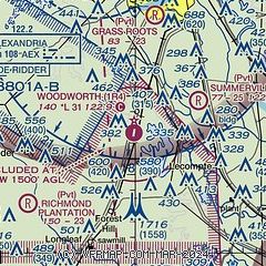
| Sectional chart |
|---|
|
| Airport distance calculator |
|---|
|
|
| Sunrise and sunset |
|---|
|
Times for 05-Jan-2026
| | Local
(UTC-6) | | Zulu
(UTC) |
|---|
| Morning civil twilight | | 06:44 | | 12:44 |
| Sunrise | | 07:10 | | 13:10 |
| Sunset | | 17:21 | | 23:21 |
| Evening civil twilight | | 17:47 | | 23:47 |
|
| Current date and time |
|---|
| Zulu (UTC) | 06-Jan-2026 03:59:33 |
|---|
| Local (UTC-6) | 05-Jan-2026 21:59:33 |
|---|
|
| METAR |
|---|
KAEX
13nm N | 060353Z 15008KT 8SM FEW024 16/14 A2996 RMK AO2 SLP149 T01560144 $
|
KESF
20nm NE | 060353Z AUTO 16004KT 10SM FEW031 14/13 A2996 RMK AO2 SLP143 T01390128
|
KBKB
22nm W | 060349Z AUTO VRB03KT 7SM BKN007 17/16 A2993 RMK AO2 SLP162 T01670156
|
KMKV
22nm E | 060335Z AUTO 18005KT 10SM CLR 16/15 A3000 RMK AO2 T01590147
|
KACP
25nm SW | 060335Z AUTO 00000KT 10SM BKN007 OVC018 16/14 A2999 RMK AO2
|
KPOE
25nm W | 060355Z AUTO 17009KT 7SM OVC004 17/16 A2994 RMK AO2 OVC V BKN SLP141 T01680161
|
|
| TAF |
|---|
KAEX
13nm N | 051725Z 0518/0618 18008KT P6SM SCT015 FM060600 17006KT P6SM OVC050 FM060800 17008KT 1SM BR OVC004 FM061500 22010KT 4SM BR OVC010
|
|
| NOTAMs |
|---|
NOTAMs are issued by the DoD/FAA and will open in a separate window not controlled by AirNav.
|
|

