FAA INFORMATION EFFECTIVE 16 APRIL 2026
Location
| FAA Identifier: | AEX |
| Lat/Long: | 31-19-38.5380N 092-32-54.8010W
31-19.642300N 092-32.913350W
31.3273717,-92.5485558
(estimated) |
| Elevation: | 88.1 ft. / 26.9 m (surveyed) |
| Variation: | 03E (1995) |
| From city: | 4 miles W of ALEXANDRIA, LA |
| Time zone: | UTC -5 (UTC -6 during Standard Time) |
| Zip code: | 71303 |
Airport Operations
| Airport use: | Open to the public |
| Activation date: | 02/1944 |
| Control tower: | yes |
| ARTCC: | HOUSTON CENTER |
| FSS: | DE RIDDER FLIGHT SERVICE STATION |
| NOTAMs facility: | AEX (NOTAM-D service available) |
| Attendance: | CONTINUOUS |
| Pattern altitude: | 1288.1 ft. MSL
RIGHT RETANGULAR 1200 FT AGL, LEFT OVERHEAD 1700 FT AGL. |
| Wind indicator: | lighted |
| Segmented circle: | yes |
| Lights: | SS-SR |
| Beacon: | white-green (lighted land airport)
Operates sunset to sunrise. |
| Fire and rescue: | ARFF index D |
Airport Communications
| CTAF: | 127.35 |
| WX ASOS: | 123.975 (318-442-6583) |
| ALEXANDRIA GROUND: | 121.9 372.0 |
| ALEXANDRIA TOWER: | 127.35 269.2 |
| MAKS APPROACH: | 125.4 |
| MAKS DEPARTURE: | 125.4 |
| CLEARANCE DELIVERY: | 121.9 |
| EMERG: | 121.5 243.0 |
| WX ASOS at ESF (14 nm E): | 119.425 (318-484-9031) |
- MULTICOM FREQ 130.00 AVBL.
Nearby radio navigation aids
| VOR radial/distance | | VOR name | | Freq | | Var |
|---|
| AEXr327/4.9 | | ALEXANDRIA VORTAC | | 116.10 | | 03E |
| FXUr067/(36.8) | | POLK VOR | | 108.40 | | 02E |
| NDB name | | Hdg/Dist | | Freq | | Var | | ID |
|---|
| NATCHITOCHES | | 122/33.5 | | 407 | | 04E | | OOC | --- --- -.-. |
Airport Services
| Fuel available: | 100 JET-A MOGAS |
| Parking: | hangars and tiedowns |
| Airframe service: | MAJOR |
| Powerplant service: | MAJOR |
| Bottled oxygen: | LOW |
| Bulk oxygen: | LOW |
Runway Information
Runway 14/32
| Dimensions: | 9352 x 150 ft. / 2850 x 46 m |
| Surface: | concrete/grooved, in good condition |
| Weight bearing capacity: | | Single wheel: | 81.0 | | Double wheel: | 180.0 | | Double tandem: | 330.0 | | Dual double tandem: | 850.0 |
|
| Runway edge lights: | high intensity |
| RUNWAY 14 | | RUNWAY 32 |
| Latitude: | 31-20.272642N | | 31-19.025092N |
| Longitude: | 092-33.553612W | | 092-32.496703W |
| Elevation: | 83.7 ft. | | 88.0 ft. |
| Traffic pattern: | left | | left |
| Runway heading: | 141 magnetic, 144 true | | 321 magnetic, 324 true |
| Declared distances: | TORA:9352 TODA:9352 ASDA:9352 LDA:9352 | | TORA:9352 TODA:9352 ASDA:9352 LDA:9352 |
| Markings: | precision, in good condition | | precision, in good condition |
| Visual slope indicator: | 4-light PAPI on left (3.00 degrees glide path) | | 4-light PAPI on left (3.00 degrees glide path) |
| RVR equipment: | touchdown, rollout | | touchdown, rollout |
| Approach lights: | MALSR: 1,400 foot medium intensity approach lighting system with runway alignment indicator lights | | |
| Runway end identifier lights: | | | yes |
| Touchdown point: | yes, lighted | | yes, no lights |
| Instrument approach: | LOC/GS | | |
Runway 18/36
| Dimensions: | 7001 x 150 ft. / 2134 x 46 m |
| Surface: | asphalt/concrete/grooved, in good condition
CENTER 75 FT OF FIRST 3000 FT OF RWY 18 CONC, REMAINDER IS ASPH. |
| Weight bearing capacity: | | Single wheel: | 75.0 | | Double wheel: | 130.0 | | Double tandem: | 191.0 | | Dual double tandem: | 502.0 |
|
| Runway edge lights: | high intensity |
| RUNWAY 18 | | RUNWAY 36 |
| Latitude: | 31-20.203800N | | 31-19.063215N |
| Longitude: | 092-32.659078W | | 092-32.869053W |
| Elevation: | 83.5 ft. | | 86.7 ft. |
| Traffic pattern: | left | | left |
| Runway heading: | 186 magnetic, 189 true | | 006 magnetic, 009 true |
| Declared distances: | TORA:7001 TODA:7001 ASDA:7001 LDA:7001 | | TORA:7001 TODA:7001 ASDA:7001 LDA:7001 |
| Markings: | nonprecision, in good condition | | nonprecision, in good condition |
| Visual slope indicator: | 4-light PAPI on left (3.00 degrees glide path) | | 4-light PAPI on left (3.00 degrees glide path) |
| Runway end identifier lights: | yes | | yes |
| Touchdown point: | yes, no lights | | yes, no lights |
| Obstructions: | none | | 76 ft. trees, 1798 ft. from runway, 322 ft. right of centerline, 21:1 slope to clear |
Airport Ownership and Management from official FAA records
| Ownership: | Publicly-owned |
| Owner: | ENGLAND AUTHORITY
1611 ARNOLD DR
ALEXANDRIA, LA 71303
Phone 318-449-3504 |
| Manager: | SCOTT GAMMEL
1611 ARNOLD DR
ALEXANDRIA, LA 71303
Phone 318-427-6419 |
Additional Remarks
| A39-18/36 | PCR VALUE: 580/R/A/W/T |
| A39-14/32 | PCR VALUE: 630/R/A/W/T |
| - | LGT ACFT FREQ CROSS APCH ZONES TO RWY 14/32 BLW 2000 FT MSL. |
| - | COML & LIFEGUARD ACFT ONLY ON COML TRML RAMP; ALL OTHER ACFT UTILIZE TWY A TO FBO. |
| - | EXTV LGT ACFT TFC (CROPDUSTERS) BLW 900 FT TO CIV ARPT 3.5 NM WSW OF FIELD. |
| - | EXTSV HEL TFC DURING MIL EXER. |
Instrument Procedures
NOTE: All procedures below are presented as PDF files. If you need a reader for these files, you should download the free Adobe Reader.NOT FOR NAVIGATION. Please procure official charts for flight.
FAA instrument procedures published for use from 16 April 2026 at 0901Z to 14 May 2026 at 0900Z.
IAPs - Instrument Approach Procedures |
|---|
| ILS OR LOC RWY 14 | |
download (255KB) |
| RNAV (GPS) RWY 14 | |
download (263KB) |
| RNAV (GPS) RWY 18 | |
download (256KB) |
| RNAV (GPS) RWY 32 | |
download (246KB) |
| RNAV (GPS) RWY 36 | |
download (216KB) |
| VOR/DME RWY 32 | |
download (237KB) |
| VOR RWY 14 | |
download (239KB) |
| NOTE: Special Alternate Minimums apply | |
download (182KB) |
| NOTE: Special Take-Off Minimums/Departure Procedures apply | |
download (116KB) |
Other nearby airports with instrument procedures:
KESF - Esler Regional Airport (14 nm E)
2R6 - Bunkie Municipal Airport (27 nm SE)
KMKV - Marksville Municipal Airport (28 nm SE)
KACP - Allen Parish Airport (35 nm S)
KPOE - Maks Army Air Field (37 nm SW)
|
|

Road maps at:
MapQuest
Bing
Google
| Aerial photo |
|---|
WARNING: Photo may not be current or correct
 Photo by Jordan and Kirsten Eastridge
Photo taken 21-Apr-2010
Photo by Jordan and Kirsten Eastridge
Photo taken 21-Apr-2010
Do you have a better or more recent aerial photo of Alexandria International Airport that you would like to share? If so, please send us your photo.
|
| Sectional chart |
|---|
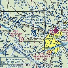
|
CAUTION: Diagram may not be current
 Download PDF
of official airport diagram from the FAA
| Airport distance calculator |
|---|
|
|
| Sunrise and sunset |
|---|
|
Times for 08-May-2026
| | Local
(UTC-5) | | Zulu
(UTC) |
|---|
| Morning civil twilight | | 05:54 | | 10:54 |
| Sunrise | | 06:20 | | 11:20 |
| Sunset | | 19:53 | | 00:53 |
| Evening civil twilight | | 20:19 | | 01:19 |
|
| Current date and time |
|---|
| Zulu (UTC) | 09-May-2026 00:44:58 |
|---|
| Local (UTC-5) | 08-May-2026 19:44:58 |
|---|
|
| METAR |
|---|
| KAEX | 082353Z 14006KT 10SM OVC010 21/19 A2986 RMK AO2 SLP115 T02110189 10211 20172 55005
|
KESF
14nm E | 082353Z AUTO 00000KT 10SM OVC012 21/19 A2985 RMK AO2 SLP106 T02060189 10217 20167 57007
|
|
| TAF |
|---|
| KAEX | 081741Z 0818/0918 08008KT P6SM VCSH OVC007 FM090100 12006KT 6SM BR OVC007 FM090600 VRB04KT 6SM BR VCSH OVC007
|
|
| NOTAMs |
|---|
NOTAMs are issued by the DoD/FAA and will open in a separate window not controlled by AirNav.
|
|


