FAA INFORMATION EFFECTIVE 14 MAY 2026
Location
| FAA Identifier: | 2O6 |
| Lat/Long: | 37-06-47.8000N 120-14-49.2000W
37-06.796667N 120-14.820000W
37.1132778,-120.2470000
(estimated) |
| Elevation: | 243 ft. / 74 m (estimated) |
| Variation: | 15E (1985) |
| From city: | 1 mile SE of CHOWCHILLA, CA |
| Time zone: | UTC -7 (UTC -8 during Standard Time) |
| Zip code: | 93610 |
Airport Operations
| Airport use: | Open to the public |
| Activation date: | 08/1949 |
| Control tower: | no |
| ARTCC: | OAKLAND CENTER |
| FSS: | RANCHO MURIETA FLIGHT SERVICE STATION |
| NOTAMs facility: | RIU (NOTAM-D service available) |
| Attendance: | UNATNDD |
| Wind indicator: | lighted |
| Segmented circle: | yes |
| Lights: | ACTVT MIRL RY 12/30 - CTAF. |
Airport Communications
| CTAF: | 122.9 |
| WX ASOS at MAE (10 nm SE): | 134.725 (559-674-1781) |
| WX ASOS at MCE (16 nm NW): | 132.175 (209-381-0926) |
Nearby radio navigation aids
| VOR radial/distance | | VOR name | | Freq | | Var |
|---|
| HYPr116/9.7 | | EL NIDO VOR/DME | | 113.85 | | 15E |
| FRAr254/31.2 | | FRIANT VORTAC | | 115.60 | | 17E |
| PXNr031/34.9 | | PANOCHE VORTAC | | 112.60 | | 16E |
Airport Services
| Parking: | tiedowns |
| Bottled oxygen: | NONE |
| Bulk oxygen: | NONE |
Runway Information
Runway 12/30
| Dimensions: | 3253 x 60 ft. / 992 x 18 m
300 FT STOPWAYS AT BOTH ENDS OF RY. |
| Surface: | asphalt, in fair condition |
| Weight bearing capacity: | |
| Runway edge lights: | medium intensity |
| RUNWAY 12 | | RUNWAY 30 |
| Latitude: | 37-06.986608N | | 37-06.608078N |
| Longitude: | 120-15.056538W | | 120-14.582597W |
| Elevation: | 238.2 ft. | | 243.0 ft. |
| Traffic pattern: | left | | right |
| Runway heading: | 119 magnetic, 134 true | | 299 magnetic, 314 true |
| Markings: | basic, in fair condition | | basic, in fair condition |
| Runway end identifier lights: | no | | no |
| Touchdown point: | yes, no lights | | yes, no lights |
| Obstructions: | 60 ft. ant, 1500 ft. from runway, 100 ft. right of centerline, 21:1 slope to clear
50 FT TOWER 300 FT LEFT OF RWY 30 CNTRLN. | | 50 ft. tower, lighted, 500 ft. from runway, 300 ft. left of centerline, 6:1 slope to clear |
Airport Ownership and Management from official FAA records
| Ownership: | Publicly-owned |
| Owner: | CITY OF CHOWCHILLA
130 SOUTH 2ND STREET
CHOWCHILLA, CA 93610
Phone 559-665-8615 |
| Manager: | JASON ROGERS
130 SOUTH 2ND STREET
CHOWCHILLA, CA 93610
Phone (559) 267-3157
EXT 300 |
Additional Remarks
| - | APCH TO RWY 12 +35' POWERLINES 1150' FM THR ON EXTNDD RY CNTRLN. |
| - | FOR CD CTC NORCAL APCH AT 916-361-0516. |
Instrument Procedures
There are no published instrument procedures at 2O6.
Some nearby airports with instrument procedures:
KMAE - Madera Municipal Airport (10 nm SE)
KMCE - Merced Yosemite Regional Airport (16 nm NW)
F34 - Firebaugh Airport (18 nm SW)
KMER - Castle Airport (22 nm NW)
KMPI - Mariposa-Yosemite Airport (26 nm N)
|
|

Road maps at:
MapQuest
Bing
Google
| Aerial photo |
|---|
WARNING: Photo may not be current or correct
 Photo by David Newcomer
Photo taken 24-Oct-2014
from 3,000 AGL looking northeast.
Photo by David Newcomer
Photo taken 24-Oct-2014
from 3,000 AGL looking northeast.
Do you have a better or more recent aerial photo of Chowchilla Airport that you would like to share? If so, please send us your photo.
|
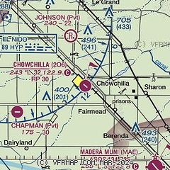
| Sectional chart |
|---|
|
| Airport distance calculator |
|---|
|
|
| Sunrise and sunset |
|---|
|
Times for 16-May-2026
| | Local
(UTC-7) | | Zulu
(UTC) |
|---|
| Morning civil twilight | | 05:24 | | 12:24 |
| Sunrise | | 05:53 | | 12:53 |
| Sunset | | 20:02 | | 03:02 |
| Evening civil twilight | | 20:31 | | 03:31 |
|
| Current date and time |
|---|
| Zulu (UTC) | 16-May-2026 23:10:57 |
|---|
| Local (UTC-7) | 16-May-2026 16:10:57 |
|---|
|
| METAR |
|---|
KMAE
10nm SE | 162253Z AUTO 31020G30KT 10SM CLR 27/06 A2987 RMK AO2 PK WND 32030/2247 SLP111 T02720056
|
KMCE
16nm NW | 162253Z AUTO 32013G24KT 10SM CLR 27/05 A2986 RMK AO2 PK WND 31030/2218 SLP111 T02720050
|
|
| TAF |
|---|
KMCE
16nm NW | 161720Z 1618/1718 32015G20KT P6SM SKC FM162000 33019G26KT P6SM SKC FM170600 30011KT P6SM SKC FM171200 32015G25KT P6SM SKC
|
|
| NOTAMs |
|---|
NOTAMs are issued by the DoD/FAA and will open in a separate window not controlled by AirNav.
|
|

